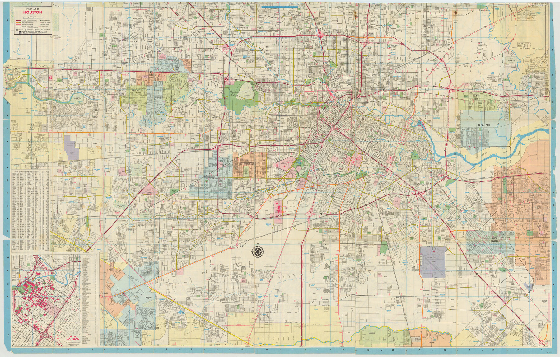
General Homes Free Houston Area Map
[Recto - Street Map of Houston]
-
Map/Doc
94393
-
Collection
General Map Collection
-
People and Organizations
H.M. Gousha (Publisher)
-
Counties
Harris
-
Subjects
City
-
Height x Width
27.1 x 42.5 inches
68.8 x 108.0 cm
-
Medium
paper, etching/engraving/lithograph
-
Comments
For maps of northern part of Houston and of Houston and Vicinity on verso, see 94394. For research only.
Related maps
General Homes Free Houston Area Map

General Homes Free Houston Area Map
Size 27.3 x 42.5 inches
Map/Doc 94394
Part of: General Map Collection
Irion County Sketch File 9

Print $14.00
- Digital $50.00
Irion County Sketch File 9
1927
Size 11.0 x 8.5 inches
Map/Doc 27475
Kerr County Working Sketch 6

Print $20.00
- Digital $50.00
Kerr County Working Sketch 6
1947
Size 32.8 x 26.3 inches
Map/Doc 70037
Connected Map of Austin's Colony

Print $40.00
- Digital $50.00
Connected Map of Austin's Colony
1837
Size 93.2 x 43.7 inches
Map/Doc 93377
Runnels County Working Sketch 9

Print $40.00
- Digital $50.00
Runnels County Working Sketch 9
1948
Size 48.9 x 27.9 inches
Map/Doc 63605
Reagan County Sketch File 11

Print $20.00
- Digital $50.00
Reagan County Sketch File 11
1928
Size 26.7 x 22.2 inches
Map/Doc 12217
Brewster County Sketch File 24

Print $40.00
- Digital $50.00
Brewster County Sketch File 24
1957
Size 14.3 x 15.5 inches
Map/Doc 15831
Harris County Sketch File 33a

Print $20.00
- Digital $50.00
Harris County Sketch File 33a
Size 34.1 x 30.0 inches
Map/Doc 10478
Webb County Working Sketch 25

Print $20.00
- Digital $50.00
Webb County Working Sketch 25
1928
Size 38.8 x 31.2 inches
Map/Doc 72390
Map of Lampasas Co.

Print $20.00
- Digital $50.00
Map of Lampasas Co.
1888
Size 34.4 x 42.4 inches
Map/Doc 5080
Harrison County Sketch File 7

Print $6.00
- Digital $50.00
Harrison County Sketch File 7
1858
Size 11.7 x 9.7 inches
Map/Doc 26046
Fisher County Working Sketch 9

Print $20.00
- Digital $50.00
Fisher County Working Sketch 9
1947
Size 18.1 x 17.9 inches
Map/Doc 69143
Crane County Sketch File 3c

Print $6.00
- Digital $50.00
Crane County Sketch File 3c
1884
Size 12.8 x 7.9 inches
Map/Doc 19559
You may also like
Bandera County Working Sketch 60

Print $20.00
- Digital $50.00
Bandera County Working Sketch 60
2004
Size 32.1 x 43.6 inches
Map/Doc 83562
Flight Mission No. BRE-3P, Frame 37, Nueces County

Print $20.00
- Digital $50.00
Flight Mission No. BRE-3P, Frame 37, Nueces County
1956
Size 18.4 x 22.4 inches
Map/Doc 86815

Surveys made on La Parita, March 1847

Print $2.00
- Digital $50.00
Surveys made on La Parita, March 1847
1847
Size 10.1 x 7.5 inches
Map/Doc 222
[East line of Wheeler County along Oklahoma]
![89825, [East line of Wheeler County along Oklahoma], Twichell Survey Records](https://historictexasmaps.com/wmedia_w700/maps/89825-1.tif.jpg)
Print $40.00
- Digital $50.00
[East line of Wheeler County along Oklahoma]
Size 8.5 x 62.9 inches
Map/Doc 89825
Travis County

Print $40.00
- Digital $50.00
Travis County
1880
Size 62.1 x 50.2 inches
Map/Doc 87935
Sheet 4 copied from Champlin Book 5 [Strip Map showing T. & P. connecting lines]
![93181, Sheet 4 copied from Champlin Book 5 [Strip Map showing T. & P. connecting lines], Twichell Survey Records](https://historictexasmaps.com/wmedia_w700/maps/93181-1.tif.jpg)
Print $40.00
- Digital $50.00
Sheet 4 copied from Champlin Book 5 [Strip Map showing T. & P. connecting lines]
1909
Size 8.0 x 75.7 inches
Map/Doc 93181

Uvalde County Rolled Sketch 9

Print $20.00
- Digital $50.00
Uvalde County Rolled Sketch 9
1924
Size 16.6 x 24.6 inches
Map/Doc 8094
Culberson County Working Sketch 78

Print $40.00
- Digital $50.00
Culberson County Working Sketch 78
1976
Size 51.8 x 36.2 inches
Map/Doc 68532
Houston Ship Channel, Atkinson Island to Alexander Island

Print $20.00
- Digital $50.00
Houston Ship Channel, Atkinson Island to Alexander Island
1960
Size 33.2 x 44.0 inches
Map/Doc 69900
Crane County Sketch File 23

Print $20.00
- Digital $50.00
Crane County Sketch File 23
1931
Size 21.3 x 39.1 inches
Map/Doc 11211