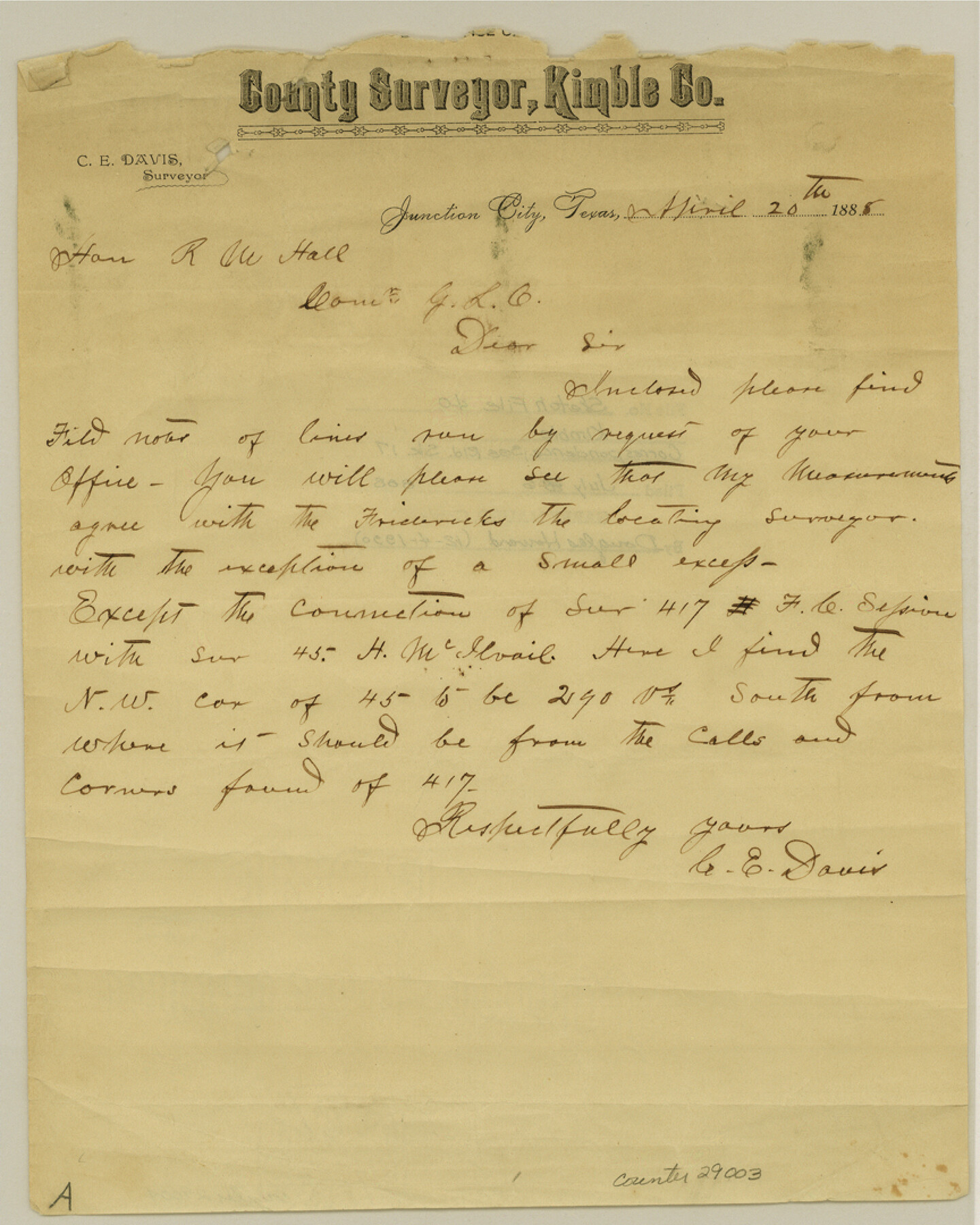
Kimble County Sketch File 40
[Correspondence and connecting lines]
-
Map/Doc
29003
-
Collection
General Map Collection
-
Object Dates
4/20/1888 (Creation Date)
7/6/1888 (File Date)
-
People and Organizations
C.E. Davis (Surveyor/Engineer)
Friederick (Surveyor/Engineer)
-
Counties
Kimble
-
Subjects
Surveying Sketch File
-
Height x Width
10.8 x 8.6 inches
27.4 x 21.8 cm
-
Medium
paper, manuscript
-
Comments
See Kimble County Rolled Sketch 17 (6509) for sketch.
-
Features
Bear Creek
Related maps
Kimble County Rolled Sketch 17

Print $20.00
- Digital $50.00
Kimble County Rolled Sketch 17
Size 19.7 x 20.5 inches
Map/Doc 6509
Part of: General Map Collection
[Surveys near Carancahua Bay]
![106, [Surveys near Carancahua Bay], General Map Collection](https://historictexasmaps.com/wmedia_w700/maps/106.tif.jpg)
Print $2.00
- Digital $50.00
[Surveys near Carancahua Bay]
1844
Size 13.1 x 8.0 inches
Map/Doc 106
Panola County Rolled Sketch 7

Print $20.00
- Digital $50.00
Panola County Rolled Sketch 7
Size 18.6 x 23.4 inches
Map/Doc 7200
Padre Island, Register No. 1485b

Print $40.00
- Digital $50.00
Padre Island, Register No. 1485b
1881
Size 55.6 x 37.3 inches
Map/Doc 73608
Chambers County Rolled Sketch 32

Print $20.00
- Digital $50.00
Chambers County Rolled Sketch 32
1951
Size 26.7 x 37.8 inches
Map/Doc 5432
Map of Freeport, Brazoria County, Texas

Print $20.00
- Digital $50.00
Map of Freeport, Brazoria County, Texas
Size 27.0 x 39.1 inches
Map/Doc 7689
Reeves County Working Sketch 1

Print $40.00
- Digital $50.00
Reeves County Working Sketch 1
Size 48.6 x 38.2 inches
Map/Doc 63443
Jefferson County Sketch File X

Print $42.00
- Digital $50.00
Jefferson County Sketch File X
Size 17.1 x 13.3 inches
Map/Doc 28087
McMullen County Sketch File 25

Print $6.00
- Digital $50.00
McMullen County Sketch File 25
1877
Size 8.5 x 14.2 inches
Map/Doc 31383
Edwards County Working Sketch 10

Print $20.00
- Digital $50.00
Edwards County Working Sketch 10
1920
Size 21.9 x 18.3 inches
Map/Doc 68886
[Sketch for Mineral Application 26501 - Sabine River, T. A. Oldhausen]
![2833, [Sketch for Mineral Application 26501 - Sabine River, T. A. Oldhausen], General Map Collection](https://historictexasmaps.com/wmedia_w700/maps/2833.tif.jpg)
Print $20.00
- Digital $50.00
[Sketch for Mineral Application 26501 - Sabine River, T. A. Oldhausen]
1931
Size 24.4 x 36.3 inches
Map/Doc 2833
Duval County Sketch File 34

Print $20.00
- Digital $50.00
Duval County Sketch File 34
Size 28.4 x 36.9 inches
Map/Doc 11391
Bell County Sketch File 36

Print $12.00
- Digital $50.00
Bell County Sketch File 36
1839
Size 6.8 x 8.4 inches
Map/Doc 14457
You may also like
Gaines County Sketch File 25

Print $4.00
- Digital $50.00
Gaines County Sketch File 25
2002
Size 11.0 x 8.5 inches
Map/Doc 82618
Flight Mission No. DQN-2K, Frame 22, Calhoun County

Print $20.00
- Digital $50.00
Flight Mission No. DQN-2K, Frame 22, Calhoun County
1953
Size 16.9 x 18.9 inches
Map/Doc 84229
Grimes County Working Sketch Graphic Index

Print $40.00
- Digital $50.00
Grimes County Working Sketch Graphic Index
1922
Size 54.9 x 29.4 inches
Map/Doc 76560
Tarrant County

Print $20.00
- Digital $50.00
Tarrant County
1873
Size 19.6 x 18.0 inches
Map/Doc 4630
Bowie County Working Sketch 22

Print $40.00
- Digital $50.00
Bowie County Working Sketch 22
1968
Size 49.0 x 37.8 inches
Map/Doc 67426
[Surveys on the San Marcos River]
![149, [Surveys on the San Marcos River], General Map Collection](https://historictexasmaps.com/wmedia_w700/maps/149.tif.jpg)
Print $20.00
- Digital $50.00
[Surveys on the San Marcos River]
Size 14.1 x 12.4 inches
Map/Doc 149
Concho County Sketch File 46

Print $24.00
- Digital $50.00
Concho County Sketch File 46
1961
Size 14.2 x 8.6 inches
Map/Doc 19213
Bastrop County Working Sketch 8

Print $20.00
- Digital $50.00
Bastrop County Working Sketch 8
1937
Size 23.9 x 43.1 inches
Map/Doc 67308
Midland County Rolled Sketch 7

Print $40.00
- Digital $50.00
Midland County Rolled Sketch 7
1951
Size 77.3 x 25.2 inches
Map/Doc 9519
Atascosa County Sketch File 8a

Print $4.00
- Digital $50.00
Atascosa County Sketch File 8a
Size 13.9 x 8.4 inches
Map/Doc 13761
Edwards County Working Sketch 38

Print $20.00
- Digital $50.00
Edwards County Working Sketch 38
1948
Size 28.4 x 43.9 inches
Map/Doc 68914
[Portions of Blocks 3T, G. & M. Block 3, Block 47, and Block J]
![91522, [Portions of Blocks 3T, G. & M. Block 3, Block 47, and Block J], Twichell Survey Records](https://historictexasmaps.com/wmedia_w700/maps/91522-1.tif.jpg)
Print $20.00
- Digital $50.00
[Portions of Blocks 3T, G. & M. Block 3, Block 47, and Block J]
Size 16.0 x 23.1 inches
Map/Doc 91522