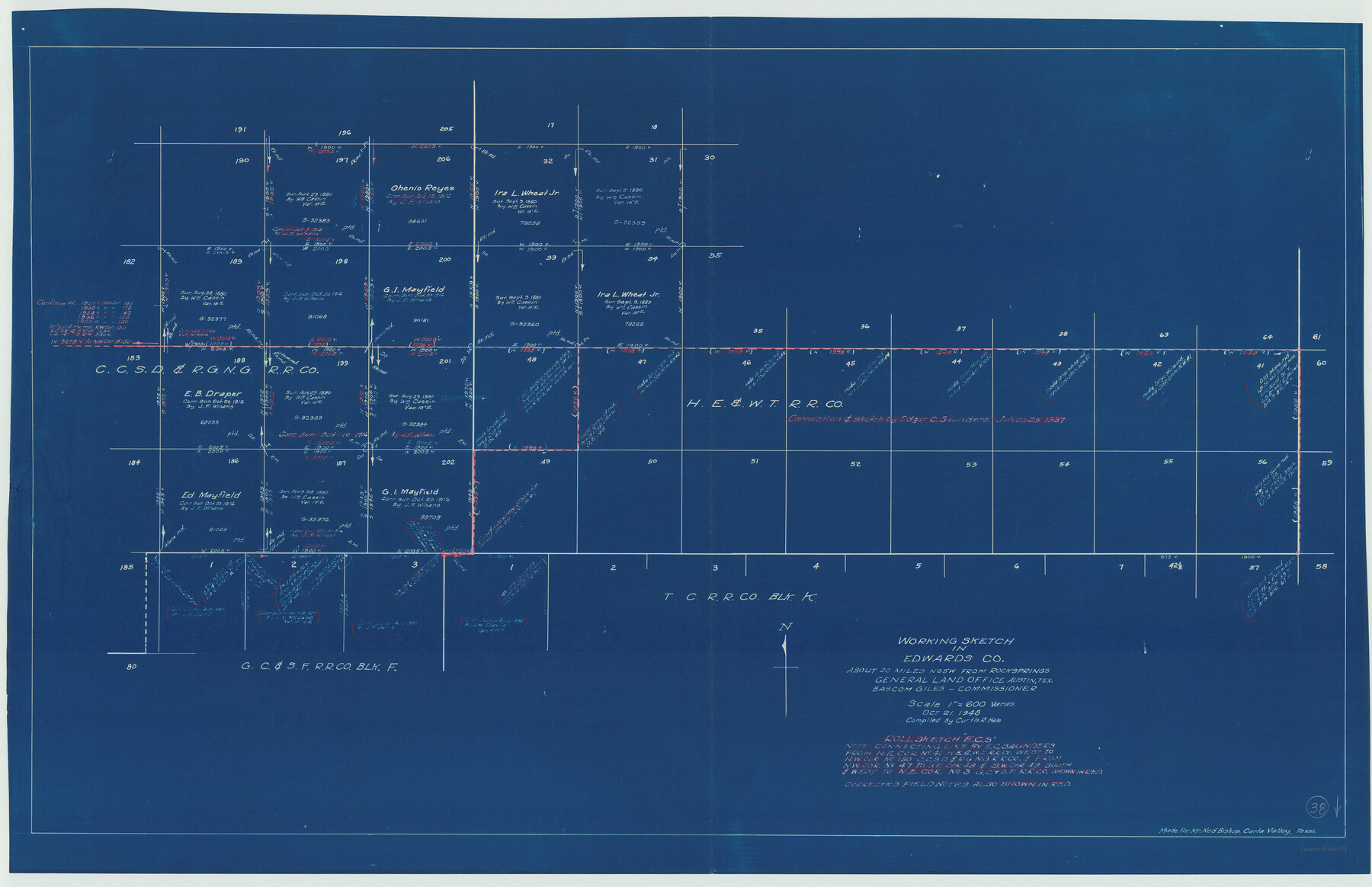
Edwards County Working Sketch 38
-
Map/Doc
68914
-
Collection
General Map Collection
-
Object Dates
10/21/1948 (Creation Date)
-
People and Organizations
Curtis R. Hale (Draftsman)
-
Counties
Edwards
-
Subjects
Surveying Working Sketch
-
Height x Width
28.4 x 43.9 inches
72.1 x 111.5 cm
-
Scale
1" = 600 varas
Part of: General Map Collection
Crockett County Rolled Sketch 37

Print $20.00
- Digital $50.00
Crockett County Rolled Sketch 37
Size 36.7 x 29.3 inches
Map/Doc 5589
Callahan County Sketch File 6

Print $42.00
- Digital $50.00
Callahan County Sketch File 6
1858
Size 8.2 x 6.4 inches
Map/Doc 35859
Crane County Working Sketch 24

Print $20.00
- Digital $50.00
Crane County Working Sketch 24
1966
Size 28.7 x 33.3 inches
Map/Doc 68301


Erath County Working Sketch 47

Print $20.00
- Digital $50.00
Erath County Working Sketch 47
1984
Size 16.3 x 18.3 inches
Map/Doc 69128
Morris County Rolled Sketch 2A

Print $20.00
- Digital $50.00
Morris County Rolled Sketch 2A
Size 24.0 x 18.7 inches
Map/Doc 10256
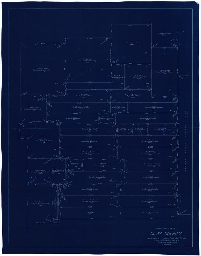
Clay County Working Sketch 9
Print $20.00
- Digital $50.00
Clay County Working Sketch 9
1938
Size 37.5 x 29.4 inches
Map/Doc 68032
Anderson County Sketch File 13

Print $10.00
- Digital $50.00
Anderson County Sketch File 13
1856
Size 8.1 x 8.3 inches
Map/Doc 12774
[John Schrier's league]
![286, [John Schrier's league], General Map Collection](https://historictexasmaps.com/wmedia_w700/maps/286.tif.jpg)
Print $2.00
- Digital $50.00
[John Schrier's league]
1847
Size 7.2 x 8.6 inches
Map/Doc 286
Flight Mission No. BRA-16M, Frame 94, Jefferson County

Print $20.00
- Digital $50.00
Flight Mission No. BRA-16M, Frame 94, Jefferson County
1953
Size 18.5 x 22.1 inches
Map/Doc 85706
Flight Mission No. DCL-6C, Frame 77, Kenedy County

Print $20.00
- Digital $50.00
Flight Mission No. DCL-6C, Frame 77, Kenedy County
1943
Size 18.5 x 22.3 inches
Map/Doc 85919
You may also like
Kimble County Rolled Sketch 31

Print $20.00
- Digital $50.00
Kimble County Rolled Sketch 31
Size 21.1 x 27.4 inches
Map/Doc 6521
Wilbarger County Sketch File 2

Print $4.00
- Digital $50.00
Wilbarger County Sketch File 2
1862
Size 8.9 x 7.9 inches
Map/Doc 40164
Menard County Rolled Sketch 16

Print $20.00
- Digital $50.00
Menard County Rolled Sketch 16
1983
Size 29.8 x 36.6 inches
Map/Doc 6762
[John H. Stephens Blk. S-2, Capitol Lgs. to North and County School to the South]
![90241, [John H. Stephens Blk. S-2, Capitol Lgs. to North and County School to the South], Twichell Survey Records](https://historictexasmaps.com/wmedia_w700/maps/90241-1.tif.jpg)
Print $20.00
- Digital $50.00
[John H. Stephens Blk. S-2, Capitol Lgs. to North and County School to the South]
1903
Size 20.7 x 18.3 inches
Map/Doc 90241
Hartley County Working Sketch 5

Print $20.00
- Digital $50.00
Hartley County Working Sketch 5
1957
Size 46.3 x 28.9 inches
Map/Doc 66055
Flight Mission No. BRA-3M, Frame 121, Jefferson County

Print $20.00
- Digital $50.00
Flight Mission No. BRA-3M, Frame 121, Jefferson County
1953
Size 18.8 x 22.3 inches
Map/Doc 85395
Live Oak County Sketch File 34

Print $28.00
- Digital $50.00
Live Oak County Sketch File 34
1963
Size 31.0 x 23.9 inches
Map/Doc 12011
Flight Mission No. CUG-1P, Frame 160, Kleberg County

Print $20.00
- Digital $50.00
Flight Mission No. CUG-1P, Frame 160, Kleberg County
1956
Size 18.5 x 22.4 inches
Map/Doc 86167

Block No. 45 of the H. & T. C. R.R. Co. and Block No. 4T of the T. & N. O. R.R. Co. in Hansford and Ochiltree Cos. as resurveyed by J.L. Long, State Surveyor

Print $20.00
- Digital $50.00
Block No. 45 of the H. & T. C. R.R. Co. and Block No. 4T of the T. & N. O. R.R. Co. in Hansford and Ochiltree Cos. as resurveyed by J.L. Long, State Surveyor
1888
Size 34.1 x 28.1 inches
Map/Doc 75820
General Highway Map, Madison County, Texas

Print $20.00
General Highway Map, Madison County, Texas
1961
Size 18.1 x 24.6 inches
Map/Doc 79581
[Columbus Tap RR. Co. Block 1-A, B. S. & F. Block 1, T. & N. O. Block 7T and vicinity]
![90577, [Columbus Tap RR. Co. Block 1-A, B. S. & F. Block 1, T. & N. O. Block 7T and vicinity], Twichell Survey Records](https://historictexasmaps.com/wmedia_w700/maps/90577-1.tif.jpg)
Print $2.00
- Digital $50.00
[Columbus Tap RR. Co. Block 1-A, B. S. & F. Block 1, T. & N. O. Block 7T and vicinity]
Size 6.1 x 9.6 inches
Map/Doc 90577