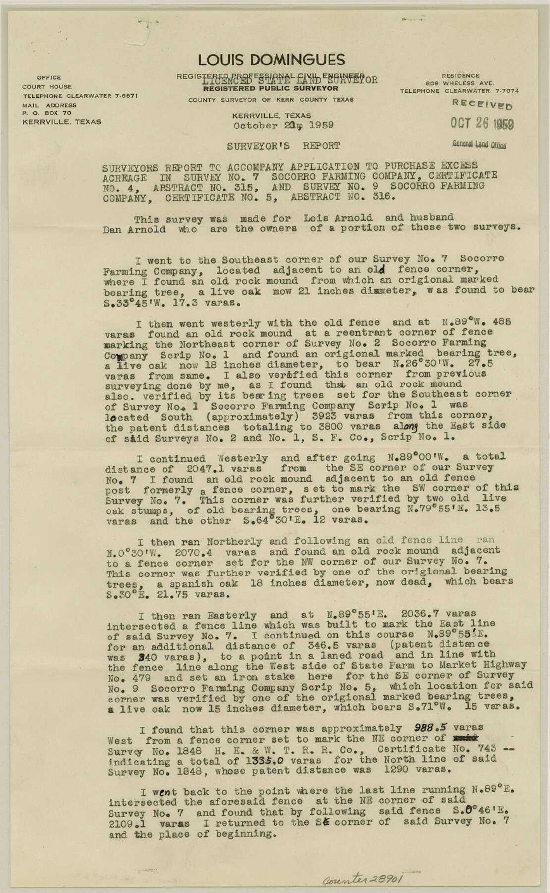
Kerr County Sketch File 23
[Surveyor's report on area northwest of Kerrville]
-
Map/Doc
28901
-
Collection
General Map Collection
-
Object Dates
10/21/1959 (Creation Date)
10/26/1959 (File Date)
10/21/1959 (Correspondence Date)
-
People and Organizations
Louis Domingues (Surveyor/Engineer)
-
Counties
Kerr
-
Subjects
Surveying Sketch File
-
Height x Width
14.2 x 8.8 inches
36.1 x 22.4 cm
-
Medium
paper, print
-
Comments
See Kerr County Rolled Sketch 21 (9348) for sketch.
-
Features
FM 479
Related maps
Kerr County Rolled Sketch 21

Print $20.00
- Digital $50.00
Kerr County Rolled Sketch 21
1959
Size 44.5 x 30.5 inches
Map/Doc 9348
Part of: General Map Collection
A New and Accurate Map of Louisiana with parts of Florida and Canada and the Adjacent Countries

Print $20.00
- Digital $50.00
A New and Accurate Map of Louisiana with parts of Florida and Canada and the Adjacent Countries
1747
Size 15.8 x 18.6 inches
Map/Doc 93680
Jackson County

Print $20.00
- Digital $50.00
Jackson County
1920
Size 45.9 x 39.1 inches
Map/Doc 73191
Flight Mission No. CUG-2P, Frame 65, Kleberg County

Print $20.00
- Digital $50.00
Flight Mission No. CUG-2P, Frame 65, Kleberg County
1956
Size 18.5 x 22.1 inches
Map/Doc 86202
Brazoria County Working Sketch 5

Print $20.00
- Digital $50.00
Brazoria County Working Sketch 5
1921
Size 15.1 x 17.1 inches
Map/Doc 67490
Zavala County Working Sketch 11

Print $20.00
- Digital $50.00
Zavala County Working Sketch 11
1955
Size 13.8 x 22.4 inches
Map/Doc 62086
Chambers County Sketch File 50

Print $49.00
- Digital $50.00
Chambers County Sketch File 50
1917
Size 14.4 x 8.8 inches
Map/Doc 18048
Edwards County Working Sketch 132

Print $20.00
- Digital $50.00
Edwards County Working Sketch 132
1985
Size 37.1 x 37.1 inches
Map/Doc 69008
Harris County Sketch File 88

Print $171.00
- Digital $50.00
Harris County Sketch File 88
1914
Size 13.8 x 12.1 inches
Map/Doc 25555
Texas & Pacific Ry Reserve west of the Pecos River

Print $40.00
- Digital $50.00
Texas & Pacific Ry Reserve west of the Pecos River
1880
Size 43.9 x 90.6 inches
Map/Doc 3047
Mexico, Regia et Celebris Hispaniae Novae Civitas [and] Cusco, Rengi Peru in Novo Orbe Casvt
![97025, Mexico, Regia et Celebris Hispaniae Novae Civitas [and] Cusco, Rengi Peru in Novo Orbe Casvt, General Map Collection](https://historictexasmaps.com/wmedia_w700/maps/97025-1.tif.jpg)
Print $20.00
- Digital $50.00
Mexico, Regia et Celebris Hispaniae Novae Civitas [and] Cusco, Rengi Peru in Novo Orbe Casvt
1572
Size 13.8 x 20.1 inches
Map/Doc 97025
Pecos County Sketch File 83

Print $6.00
- Digital $50.00
Pecos County Sketch File 83
1884
Size 11.3 x 8.7 inches
Map/Doc 33950
Andrews County Working Sketch 18

Print $20.00
- Digital $50.00
Andrews County Working Sketch 18
1964
Size 42.2 x 26.5 inches
Map/Doc 67064
You may also like
Duval County Rolled Sketch 11

Print $20.00
- Digital $50.00
Duval County Rolled Sketch 11
Size 20.4 x 30.1 inches
Map/Doc 5733
General Highway Map, Kinney County, Uvalde County, Texas

Print $20.00
General Highway Map, Kinney County, Uvalde County, Texas
1940
Size 18.4 x 24.8 inches
Map/Doc 79162
Intracoastal Waterway in Texas - Corpus Christi to Point Isabel including Arroyo Colorado to Mo. Pac. R.R. Bridge Near Harlingen

Print $20.00
- Digital $50.00
Intracoastal Waterway in Texas - Corpus Christi to Point Isabel including Arroyo Colorado to Mo. Pac. R.R. Bridge Near Harlingen
1933
Size 27.9 x 40.7 inches
Map/Doc 61863
Flight Mission No. DCL-4C, Frame 6, Kenedy County

Print $20.00
- Digital $50.00
Flight Mission No. DCL-4C, Frame 6, Kenedy County
1943
Size 18.6 x 22.2 inches
Map/Doc 85807
Denton County Working Sketch 26

Print $20.00
- Digital $50.00
Denton County Working Sketch 26
1995
Size 29.3 x 33.9 inches
Map/Doc 68631
Right of Way & Track Map, St. Louis, Brownsville & Mexico Ry. operated by St. Louis, Brownsville & Mexico Ry. Co.

Print $40.00
- Digital $50.00
Right of Way & Track Map, St. Louis, Brownsville & Mexico Ry. operated by St. Louis, Brownsville & Mexico Ry. Co.
1919
Size 25.5 x 57.0 inches
Map/Doc 64626
San Patricio County Sketch File 23

Print $20.00
San Patricio County Sketch File 23
1910
Size 22.9 x 12.9 inches
Map/Doc 12286
La Salle County Sketch File 12

Print $15.00
- Digital $50.00
La Salle County Sketch File 12
1877
Size 10.0 x 8.1 inches
Map/Doc 29470
Pecos County Rolled Sketch Q

Print $20.00
- Digital $50.00
Pecos County Rolled Sketch Q
Size 18.7 x 12.2 inches
Map/Doc 7311
Lampasas County Sketch File 9c

Print $4.00
- Digital $50.00
Lampasas County Sketch File 9c
1873
Size 12.7 x 8.1 inches
Map/Doc 29414
Hutchinson County Working Sketch Graphic Index - sheet 1

Print $20.00
- Digital $50.00
Hutchinson County Working Sketch Graphic Index - sheet 1
1922
Size 44.1 x 36.8 inches
Map/Doc 76586
Terrell County Working Sketch 32

Print $20.00
- Digital $50.00
Terrell County Working Sketch 32
1945
Size 33.0 x 36.9 inches
Map/Doc 62124