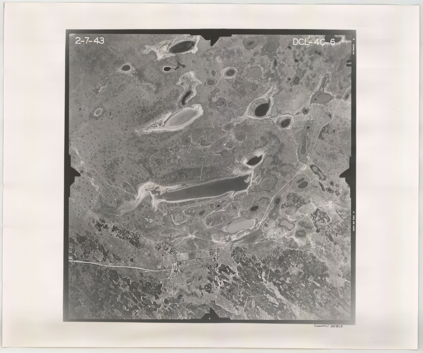
Flight Mission No. DCL-4C, Frame 6, Kenedy County
DCL-4C-6
-
Map/Doc
85807
-
Collection
General Map Collection
-
Object Dates
1943/2/7 (Creation Date)
-
People and Organizations
U. S. Department of Agriculture (Publisher)
-
Counties
Kenedy
-
Subjects
Aerial Photograph
-
Height x Width
18.6 x 22.2 inches
47.2 x 56.4 cm
-
Comments
Flown by Aerial Surveys of Pittsburgh, Inc. of Pittsburgh, Pennsylvania.
Part of: General Map Collection
Val Verde County Sketch File XXX1

Print $20.00
- Digital $50.00
Val Verde County Sketch File XXX1
Size 18.8 x 24.0 inches
Map/Doc 12547
Navarro County Sketch File 18

Print $3.00
- Digital $50.00
Navarro County Sketch File 18
1871
Size 10.6 x 10.0 inches
Map/Doc 32335
Township No. 5 South Range No. 15 West, Indian Meridian, Oklahoma

Print $4.00
- Digital $50.00
Township No. 5 South Range No. 15 West, Indian Meridian, Oklahoma
1927
Size 18.2 x 23.9 inches
Map/Doc 75136
Sutton County Rolled Sketch 57

Print $40.00
- Digital $50.00
Sutton County Rolled Sketch 57
1958
Size 40.1 x 51.1 inches
Map/Doc 10662
Johnson County Working Sketch 21

Print $20.00
- Digital $50.00
Johnson County Working Sketch 21
1995
Size 18.1 x 29.6 inches
Map/Doc 66634
Reagan County Working Sketch 27

Print $20.00
- Digital $50.00
Reagan County Working Sketch 27
1960
Size 33.0 x 42.5 inches
Map/Doc 71869
Travis County Appraisal District Plat Map 2_0018

Print $20.00
- Digital $50.00
Travis County Appraisal District Plat Map 2_0018
Size 21.6 x 26.5 inches
Map/Doc 94208
Atascosa County Sketch File 2a

Print $40.00
- Digital $50.00
Atascosa County Sketch File 2a
Size 25.1 x 15.3 inches
Map/Doc 10858
Right of Way and Track Map, The Missouri, Kansas and Texas Ry. of Texas operated by the Missouri, Kansas and Texas Ry. of Texas, Henrietta Division

Print $40.00
- Digital $50.00
Right of Way and Track Map, The Missouri, Kansas and Texas Ry. of Texas operated by the Missouri, Kansas and Texas Ry. of Texas, Henrietta Division
1918
Size 25.4 x 57.2 inches
Map/Doc 64073
Collingsworth County Rolled Sketch 1

Print $40.00
- Digital $50.00
Collingsworth County Rolled Sketch 1
1941
Size 54.2 x 24.0 inches
Map/Doc 9664
Pecos County Working Sketch 11

Print $40.00
- Digital $50.00
Pecos County Working Sketch 11
1907
Size 48.6 x 38.2 inches
Map/Doc 71481
Carte de la Louisiane et Pays Voisins pour servir a l'Histoire Generale des Voyages

Print $20.00
- Digital $50.00
Carte de la Louisiane et Pays Voisins pour servir a l'Histoire Generale des Voyages
1757
Size 10.1 x 15.5 inches
Map/Doc 97278
You may also like
Wichita County Rolled Sketch 2

Print $20.00
- Digital $50.00
Wichita County Rolled Sketch 2
1879
Size 20.6 x 26.3 inches
Map/Doc 78471
Frio County Working Sketch 26

Print $20.00
- Digital $50.00
Frio County Working Sketch 26
2001
Size 38.0 x 42.7 inches
Map/Doc 69300
Working Sketch in Bastrop County

Print $20.00
- Digital $50.00
Working Sketch in Bastrop County
1921
Size 14.3 x 15.6 inches
Map/Doc 90233

[Sketch for Mineral Application 26543 - Sabine River, D. H. Sanford]
![65677, [Sketch for Mineral Application 26543 - Sabine River, D. H. Sanford], General Map Collection](https://historictexasmaps.com/wmedia_w700/maps/65677.tif.jpg)
Print $40.00
- Digital $50.00
[Sketch for Mineral Application 26543 - Sabine River, D. H. Sanford]
1931
Size 30.8 x 71.9 inches
Map/Doc 65677
Greer County Sketch File 3

Print $20.00
- Digital $50.00
Greer County Sketch File 3
Size 20.1 x 18.2 inches
Map/Doc 11583
Webb County Sketch File 70

Print $26.00
- Digital $50.00
Webb County Sketch File 70
Size 11.4 x 8.9 inches
Map/Doc 39875
Angelina County Sketch File 3

Print $8.00
- Digital $50.00
Angelina County Sketch File 3
Size 7.7 x 7.6 inches
Map/Doc 12922
[Sketch for Mineral Application 24072, San Jacinto River]
![65608, [Sketch for Mineral Application 24072, San Jacinto River], General Map Collection](https://historictexasmaps.com/wmedia_w700/maps/65608.tif.jpg)
Print $20.00
- Digital $50.00
[Sketch for Mineral Application 24072, San Jacinto River]
1929
Size 8.6 x 14.0 inches
Map/Doc 65608
Concho County Working Sketch 14

Print $20.00
- Digital $50.00
Concho County Working Sketch 14
1955
Size 24.7 x 21.0 inches
Map/Doc 68196
Upton County Working Sketch 4

Print $20.00
- Digital $50.00
Upton County Working Sketch 4
Size 21.8 x 33.9 inches
Map/Doc 69500
Plan of the City of Austin

Print $40.00
- Digital $50.00
Plan of the City of Austin
1840
Size 54.0 x 38.9 inches
Map/Doc 2176