San Patricio County Sketch File 23
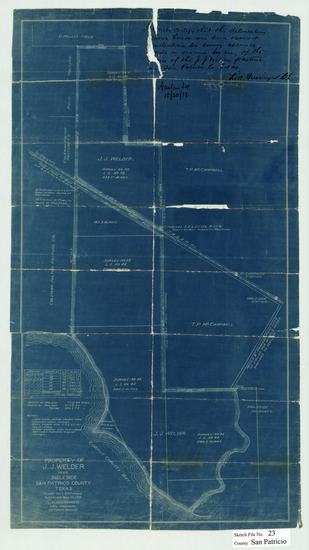
Property of J.J. Welder near Ingleside, San Patricio County, Texas
-
Map/Doc
12286
-
Collection
General Map Collection
-
Object Dates
11/22/1910 (Creation Date)
-
People and Organizations
L.A. Gueringer (Surveyor/Engineer)
-
Counties
San Patricio
-
Subjects
Surveying Sketch File
-
Height x Width
22.9 x 12.9 inches
58.2 x 32.8 cm
-
Medium
blueprint/diazo
-
Scale
1" = 500 varas
-
Features
SA&AP
Public Road to Gregory
McCampbell Station
Avenue B
Aransas Pass
Ingleside Station
Corpus Christi Bay
Kinney Bayou
Part of: General Map Collection
Brown County Sketch File 32

Print $84.00
- Digital $50.00
Brown County Sketch File 32
2018
Size 11.0 x 8.5 inches
Map/Doc 95206
McLennan County

Print $20.00
- Digital $50.00
McLennan County
1946
Size 43.8 x 46.9 inches
Map/Doc 95585
[Note to Thos. W. Ward to make corrections for J. D. Wheeler, Survey 147 in San Patricio County, San Patricio District]
![69748, [Note to Thos. W. Ward to make corrections for J. D. Wheeler, Survey 147 in San Patricio County, San Patricio District], General Map Collection](https://historictexasmaps.com/wmedia_w700/maps/69748.tif.jpg)
Print $2.00
- Digital $50.00
[Note to Thos. W. Ward to make corrections for J. D. Wheeler, Survey 147 in San Patricio County, San Patricio District]
1842
Size 4.5 x 6.8 inches
Map/Doc 69748
Flight Mission No. DCL-7C, Frame 109, Kenedy County

Print $20.00
- Digital $50.00
Flight Mission No. DCL-7C, Frame 109, Kenedy County
1943
Size 18.6 x 22.2 inches
Map/Doc 86074
Shelby County Sketch File 3

Print $4.00
- Digital $50.00
Shelby County Sketch File 3
1849
Size 11.9 x 7.9 inches
Map/Doc 36595
Bandera County Working Sketch 22

Print $20.00
- Digital $50.00
Bandera County Working Sketch 22
1949
Size 42.8 x 24.9 inches
Map/Doc 67618
Coke County Working Sketch 8

Print $20.00
- Digital $50.00
Coke County Working Sketch 8
1926
Size 26.9 x 25.5 inches
Map/Doc 68045
Goliad County Sketch File 26

Print $26.00
- Digital $50.00
Goliad County Sketch File 26
1855
Size 10.2 x 8.2 inches
Map/Doc 24308
Lamb County Sketch File 10

Print $22.00
- Digital $50.00
Lamb County Sketch File 10
1912
Size 20.0 x 31.2 inches
Map/Doc 11972
Amistad International Reservoir on Rio Grande 71

Print $20.00
- Digital $50.00
Amistad International Reservoir on Rio Grande 71
1949
Size 28.3 x 39.5 inches
Map/Doc 73358
Nueces County Sketch File 25

Print $14.00
- Digital $50.00
Nueces County Sketch File 25
1876
Size 8.7 x 6.3 inches
Map/Doc 32572
Sabine Bank to East Bay including Heald Bank

Print $20.00
- Digital $50.00
Sabine Bank to East Bay including Heald Bank
1971
Size 45.0 x 34.4 inches
Map/Doc 69849
You may also like
Map of the Missouri Pacific Central Branch U.P.R.R. St. Louis, Iron Mountain & Southern International & Great Northern and Texas and Pacific Railways

Print $20.00
- Digital $50.00
Map of the Missouri Pacific Central Branch U.P.R.R. St. Louis, Iron Mountain & Southern International & Great Northern and Texas and Pacific Railways
1890
Size 28.7 x 24.4 inches
Map/Doc 97505
Travis County Working Sketch 63

Print $20.00
- Digital $50.00
Travis County Working Sketch 63
1998
Size 24.0 x 29.5 inches
Map/Doc 69447
Harris County Working Sketch 102

Print $20.00
- Digital $50.00
Harris County Working Sketch 102
1980
Size 33.6 x 18.9 inches
Map/Doc 65994

North Part of El Paso Co.

Print $20.00
- Digital $50.00
North Part of El Paso Co.
1977
Size 36.5 x 47.8 inches
Map/Doc 95490
Hudspeth County Sketch File 31

Print $20.00
- Digital $50.00
Hudspeth County Sketch File 31
1908
Size 18.7 x 17.7 inches
Map/Doc 11805
Travis County Sketch File 8

Print $4.00
- Digital $50.00
Travis County Sketch File 8
Size 10.2 x 8.1 inches
Map/Doc 38288
Nueces County Rolled Sketch 129 A-C

Print $6.00
- Digital $50.00
Nueces County Rolled Sketch 129 A-C
1998
Size 11.2 x 8.8 inches
Map/Doc 41616
Red River County Working Sketch 75

Print $20.00
- Digital $50.00
Red River County Working Sketch 75
1980
Size 30.4 x 24.6 inches
Map/Doc 72058
Nueces County Rolled Sketch 27A

Print $40.00
- Digital $50.00
Nueces County Rolled Sketch 27A
1946
Size 11.6 x 52.4 inches
Map/Doc 76042

