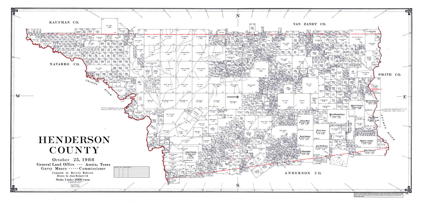
Henderson County
General Land Office Official County Map
-
Map/Doc
95528
-
Collection
General Map Collection
-
Object Dates
1988/10/25 (Creation Date)
2019/8/31 (Revision Date)
-
People and Organizations
Beverly Robison (Compiler)
Joan Kilpatrick (Draftsman)
Cheyenne Betancourt (Draftsman)
Garry Mauro (GLO Commissioner)
-
Counties
Henderson
-
Subjects
County OCM
-
Height x Width
35.3 x 69.7 inches
89.7 x 177.0 cm
-
Medium
digital image
-
Scale
1" = 2000 varas
Part of: General Map Collection
La Salle County Sketch File 33

Print $2.00
- Digital $50.00
La Salle County Sketch File 33
1875
Size 13.4 x 8.0 inches
Map/Doc 29584
Swisher County Sketch File 9

Print $4.00
- Digital $50.00
Swisher County Sketch File 9
1916
Size 11.2 x 8.7 inches
Map/Doc 37629
[Surveys in Austin's Colony along Chocolate Bayou and Austin Bayou]
![192, [Surveys in Austin's Colony along Chocolate Bayou and Austin Bayou], General Map Collection](https://historictexasmaps.com/wmedia_w700/maps/192.tif.jpg)
Print $20.00
- Digital $50.00
[Surveys in Austin's Colony along Chocolate Bayou and Austin Bayou]
1830
Size 32.9 x 10.8 inches
Map/Doc 192
Real County Sketch File 5

Print $20.00
- Digital $50.00
Real County Sketch File 5
Size 16.9 x 20.9 inches
Map/Doc 12228
Fayette County Boundary File 2a

Print $8.00
- Digital $50.00
Fayette County Boundary File 2a
Size 14.9 x 9.3 inches
Map/Doc 53345
Jack County Working Sketch 24

Print $20.00
- Digital $50.00
Jack County Working Sketch 24
2010
Size 24.1 x 29.7 inches
Map/Doc 90030
Bandera County Working Sketch 41

Print $20.00
- Digital $50.00
Bandera County Working Sketch 41
1977
Size 31.3 x 37.7 inches
Map/Doc 67637
Liberty County Sketch File 20

Print $6.00
- Digital $50.00
Liberty County Sketch File 20
Size 7.8 x 9.9 inches
Map/Doc 29925
Flight Mission No. DQN-2K, Frame 88, Calhoun County

Print $20.00
- Digital $50.00
Flight Mission No. DQN-2K, Frame 88, Calhoun County
1953
Size 18.6 x 22.3 inches
Map/Doc 84278
Winkler County Sketch File 10

Print $4.00
- Digital $50.00
Winkler County Sketch File 10
1910
Size 9.1 x 8.3 inches
Map/Doc 40486
Wilbarger County Working Sketch 16

Print $20.00
- Digital $50.00
Wilbarger County Working Sketch 16
1955
Size 32.7 x 19.9 inches
Map/Doc 72554
Bell County Sketch File 25a

Print $4.00
- Digital $50.00
Bell County Sketch File 25a
1880
Size 8.9 x 10.9 inches
Map/Doc 14424
You may also like
Sketch for Blocks D6, D7, D8 situated in Val Verde County, Texas

Print $40.00
- Digital $50.00
Sketch for Blocks D6, D7, D8 situated in Val Verde County, Texas
1937
Size 98.2 x 37.5 inches
Map/Doc 93165
Nueces County Sketch File 86

Print $2.00
- Digital $50.00
Nueces County Sketch File 86
Map/Doc 81935
Hudspeth County Sketch File 11a

Print $8.00
- Digital $50.00
Hudspeth County Sketch File 11a
Size 14.3 x 9.0 inches
Map/Doc 26910
Official Map of the State of Texas to accompany the Statistical and Descriptive Work, "Resources, Soil and Climate of Texas"

Print $20.00
- Digital $50.00
Official Map of the State of Texas to accompany the Statistical and Descriptive Work, "Resources, Soil and Climate of Texas"
1882
Size 31.1 x 33.1 inches
Map/Doc 2134
Loving County Sketch File 6

Print $10.00
- Digital $50.00
Loving County Sketch File 6
1963
Size 7.2 x 5.9 inches
Map/Doc 41451
El Paso County Working Sketch 52

Print $20.00
- Digital $50.00
El Paso County Working Sketch 52
1992
Size 29.1 x 16.1 inches
Map/Doc 69074
Flight Mission No. CRC-3R, Frame 195, Chambers County

Print $20.00
- Digital $50.00
Flight Mission No. CRC-3R, Frame 195, Chambers County
1956
Size 18.5 x 22.2 inches
Map/Doc 84850
[South Center of County near surveys 1144 and 1143]
![90502, [South Center of County near surveys 1144 and 1143], Twichell Survey Records](https://historictexasmaps.com/wmedia_w700/maps/90502-1.tif.jpg)
Print $2.00
- Digital $50.00
[South Center of County near surveys 1144 and 1143]
Size 6.6 x 16.1 inches
Map/Doc 90502
Nueces County Rolled Sketch 47

Print $20.00
- Digital $50.00
Nueces County Rolled Sketch 47
1953
Size 31.3 x 44.6 inches
Map/Doc 6886
Hood County Sketch File 22a

Print $5.00
- Digital $50.00
Hood County Sketch File 22a
Size 13.7 x 9.3 inches
Map/Doc 26617
Gregg County Boundary File 2

Print $8.00
- Digital $50.00
Gregg County Boundary File 2
Size 8.8 x 3.7 inches
Map/Doc 53984
[Surveys in Bastrop County]
![3179, [Surveys in Bastrop County], General Map Collection](https://historictexasmaps.com/wmedia_w700/maps/3179.tif.jpg)
Print $2.00
- Digital $50.00
[Surveys in Bastrop County]
1841
Size 11.3 x 8.4 inches
Map/Doc 3179