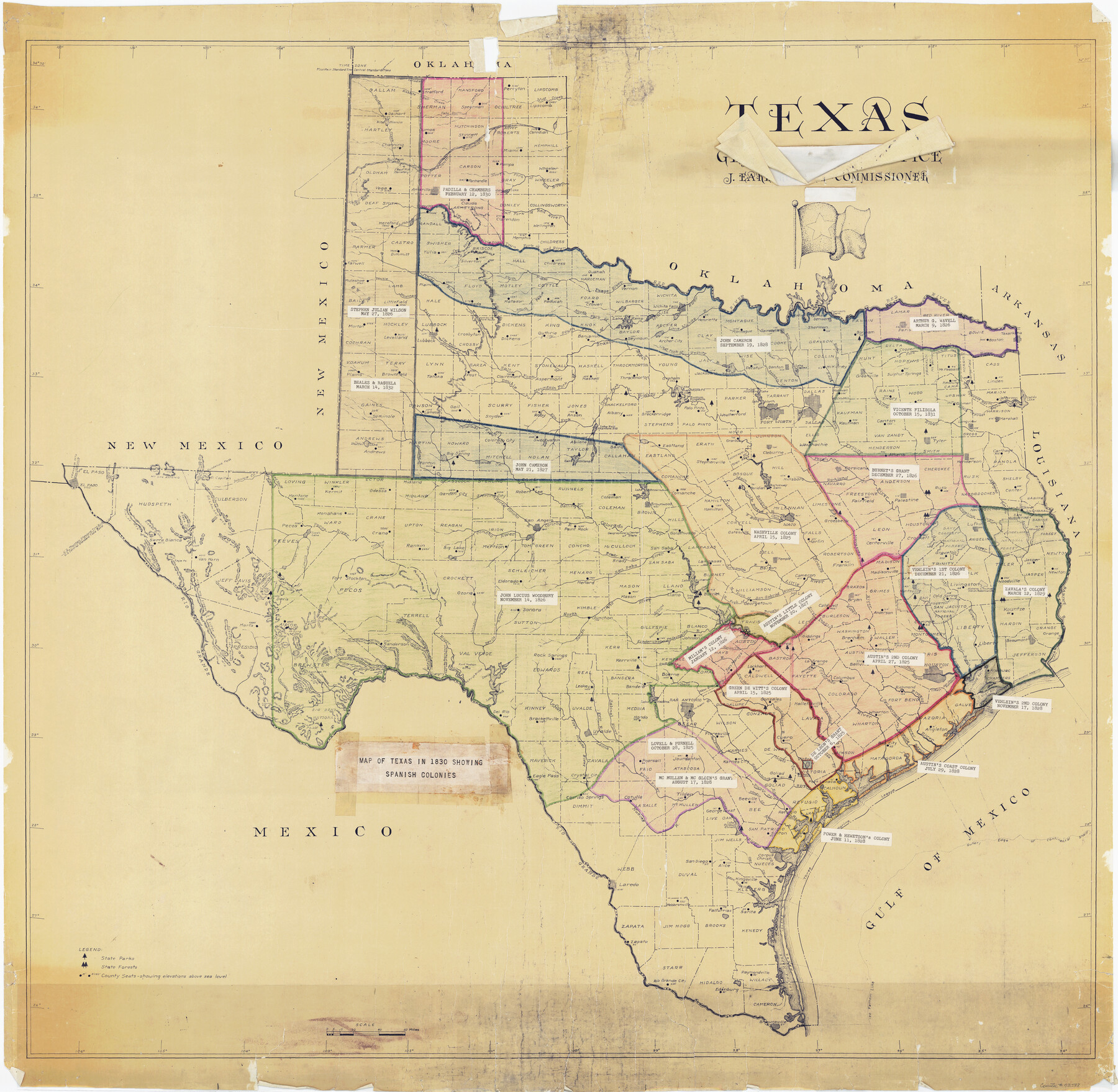
Map of Texas in 1830 Showing Spanish Colonies
RG-3-3
-
Map/Doc
73588
-
Collection
General Map Collection
-
Subjects
Colony Mexican Texas
-
Height x Width
41.1 x 42.0 inches
104.4 x 106.7 cm
-
Medium
paper, print with manuscript additions
-
Comments
Shows the location of 22 original colonies from the years of 1825 through 1832.
Part of: General Map Collection
Map and Profile No. 1 from the Red River to the Rio Grande; from Explorations and surveys made under the direction of the Hon. Jeffeson Davis, Secretary of War

Print $40.00
- Digital $50.00
Map and Profile No. 1 from the Red River to the Rio Grande; from Explorations and surveys made under the direction of the Hon. Jeffeson Davis, Secretary of War
1856
Size 30.5 x 57.0 inches
Map/Doc 4330
Railroad Track Map, H&TCRRCo., Falls County, Texas

Print $4.00
- Digital $50.00
Railroad Track Map, H&TCRRCo., Falls County, Texas
1918
Size 11.7 x 18.6 inches
Map/Doc 62835
Culberson County Rolled Sketch 59

Print $14.00
- Digital $50.00
Culberson County Rolled Sketch 59
Size 37.3 x 78.1 inches
Map/Doc 8760
[Gulf Colorado & Santa Fe from 2178+36.0 to 3901+06.2]
![64698, [Gulf Colorado & Santa Fe from 2178+36.0 to 3901+06.2], General Map Collection](https://historictexasmaps.com/wmedia_w700/maps/64698.tif.jpg)
Print $40.00
- Digital $50.00
[Gulf Colorado & Santa Fe from 2178+36.0 to 3901+06.2]
Size 123.0 x 32.2 inches
Map/Doc 64698
Galveston County Boundary File 32a

Print $10.00
- Digital $50.00
Galveston County Boundary File 32a
Size 11.4 x 8.9 inches
Map/Doc 53666
Flight Mission No. BRA-7M, Frame 10, Jefferson County

Print $20.00
- Digital $50.00
Flight Mission No. BRA-7M, Frame 10, Jefferson County
1953
Size 18.7 x 22.4 inches
Map/Doc 85461
Upton County Rolled Sketch 45

Print $20.00
- Digital $50.00
Upton County Rolled Sketch 45
Size 25.1 x 43.8 inches
Map/Doc 8081
Liberty County Rolled Sketch 15

Print $20.00
- Digital $50.00
Liberty County Rolled Sketch 15
2015
Size 36.2 x 24.5 inches
Map/Doc 94024
Surveys along the Leona River in the County of Bexar not yet connected with other surveys

Print $20.00
- Digital $50.00
Surveys along the Leona River in the County of Bexar not yet connected with other surveys
Size 21.8 x 28.7 inches
Map/Doc 70
Brewster County Rolled Sketch 98

Print $20.00
- Digital $50.00
Brewster County Rolled Sketch 98
1952
Size 29.3 x 38.0 inches
Map/Doc 8508
United States Mileage Chart / United States Mileage Table / Hawaii / Alaska

United States Mileage Chart / United States Mileage Table / Hawaii / Alaska
Size 26.5 x 38.1 inches
Map/Doc 96820
[Plat of Location and Right of Way from El Paso, Tex. To New Mexico Line, Rio Grande and El Paso R. R.]
![64084, [Plat of Location and Right of Way from El Paso, Tex. To New Mexico Line, Rio Grande and El Paso R. R.], General Map Collection](https://historictexasmaps.com/wmedia_w700/maps/64084.tif.jpg)
Print $20.00
- Digital $50.00
[Plat of Location and Right of Way from El Paso, Tex. To New Mexico Line, Rio Grande and El Paso R. R.]
Size 22.7 x 46.8 inches
Map/Doc 64084
You may also like
Tom Green County Rolled Sketch 6

Print $20.00
- Digital $50.00
Tom Green County Rolled Sketch 6
Size 21.6 x 17.1 inches
Map/Doc 7995
Real County Rolled Sketch 18

Print $20.00
- Digital $50.00
Real County Rolled Sketch 18
Size 22.2 x 28.2 inches
Map/Doc 7461
Brooks County Sketch File 9

Print $2.00
- Digital $50.00
Brooks County Sketch File 9
1988
Size 14.4 x 8.8 inches
Map/Doc 16571
Flight Mission No. DCL-7C, Frame 24, Kenedy County

Print $20.00
- Digital $50.00
Flight Mission No. DCL-7C, Frame 24, Kenedy County
1943
Size 15.5 x 15.4 inches
Map/Doc 86016
Flight Mission No. CUG-2P, Frame 25, Kleberg County

Print $20.00
- Digital $50.00
Flight Mission No. CUG-2P, Frame 25, Kleberg County
1956
Size 18.5 x 22.2 inches
Map/Doc 86189
[Blocks K3, K4, K7, K8, K14, M7, east part of Leagues]
![90593, [Blocks K3, K4, K7, K8, K14, M7, east part of Leagues], Twichell Survey Records](https://historictexasmaps.com/wmedia_w700/maps/90593-1.tif.jpg)
Print $20.00
- Digital $50.00
[Blocks K3, K4, K7, K8, K14, M7, east part of Leagues]
Size 32.6 x 32.4 inches
Map/Doc 90593
Callahan County Sketch File 7

Print $18.00
- Digital $50.00
Callahan County Sketch File 7
Size 10.8 x 8.9 inches
Map/Doc 35863
Presidio County Sketch File 19a

Print $4.00
- Digital $50.00
Presidio County Sketch File 19a
1886
Size 13.8 x 8.8 inches
Map/Doc 34452
[D. & S. E. Surs., G. C. & S. F. Blk. 9 west of University Land Blks. 49 and 50]
![90308, [D. & S. E. Surs., G. C. & S. F. Blk. 9 west of University Land Blks. 49 and 50], Twichell Survey Records](https://historictexasmaps.com/wmedia_w700/maps/90308-1.tif.jpg)
Print $3.00
- Digital $50.00
[D. & S. E. Surs., G. C. & S. F. Blk. 9 west of University Land Blks. 49 and 50]
Size 11.3 x 15.4 inches
Map/Doc 90308
Wichita County Working Sketch 13

Print $20.00
- Digital $50.00
Wichita County Working Sketch 13
1921
Size 16.5 x 32.8 inches
Map/Doc 72523
The MKT - Texas Empire of the South

Print $20.00
- Digital $50.00
The MKT - Texas Empire of the South
1905
Size 18.5 x 40.6 inches
Map/Doc 97035
Schleicher County Working Sketch 9

Print $20.00
- Digital $50.00
Schleicher County Working Sketch 9
1923
Size 12.4 x 11.8 inches
Map/Doc 63811