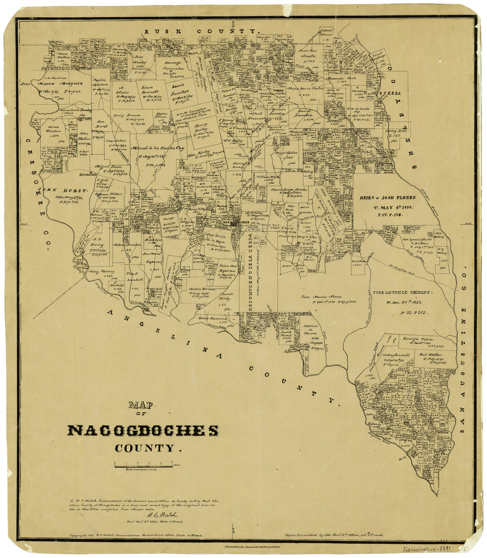
Map of Nacogdoches County
-
Map/Doc
4600
-
Collection
General Map Collection
-
Object Dates
1881 (Creation Date)
-
People and Organizations
Texas General Land Office (Publisher)
W.C. Walsh (GLO Commissioner)
G.N. Beaumont (Draftsman)
G.N. Beaumont (Compiler)
August Gast & Co. (Lithographer)
-
Counties
Nacogdoches
-
Subjects
County
-
Height x Width
24.5 x 21.5 inches
62.2 x 54.6 cm
-
Comments
Copyrighted 1881.
-
Features
Loco Bayou
Old San Antonio Road
Shelbyville Road
Arroya Amaladero
Old Nacogdoches Road
Agillitas Creek
Melrose
Caruzo Bayou
Alazon Bayou
Angelina River
White Oak Creek
Little Loco [Creek]
Bayou Morell
Dorr Creek
Arrollo Visitador
La Vaca Creek
Durazno Bayou
Bayou Carizo
Sandy Creek
Wandes Bayou
Colondrina Bayou
Douglass
Raiz Creek
Red Creek
Nacogdoches
Patonia
Lamana Bayou
Bills Creek
Pen Creek
Beeck Creek
Aycilos Crossing
Arroya Nasosote
Cany Creek
Naconiche Bayou
Attoyac Bayou
Bolija Creek
Loco Creek
Rota Creek
Part of: General Map Collection
Galveston County Rolled Sketch 34C

Print $20.00
- Digital $50.00
Galveston County Rolled Sketch 34C
1978
Size 29.0 x 40.8 inches
Map/Doc 5969
[Gulf Coast portion of] Map of the State of Texas
![72706, [Gulf Coast portion of] Map of the State of Texas, General Map Collection](https://historictexasmaps.com/wmedia_w700/maps/72706.tif.jpg)
Print $20.00
- Digital $50.00
[Gulf Coast portion of] Map of the State of Texas
1865
Size 27.2 x 18.2 inches
Map/Doc 72706
Flight Mission No. CRC-2R, Frame 193, Chambers County

Print $20.00
- Digital $50.00
Flight Mission No. CRC-2R, Frame 193, Chambers County
1956
Size 18.9 x 22.5 inches
Map/Doc 84771
F. W. & D. C. Ry. Co. Alignment and Right of Way Map, Clay County

Print $20.00
- Digital $50.00
F. W. & D. C. Ry. Co. Alignment and Right of Way Map, Clay County
1927
Size 11.8 x 18.7 inches
Map/Doc 64744
Palo Pinto County Rolled Sketch 14A

Print $20.00
- Digital $50.00
Palo Pinto County Rolled Sketch 14A
1993
Size 21.8 x 28.2 inches
Map/Doc 7195
Angelina County Sketch File 15a

Print $8.00
- Digital $50.00
Angelina County Sketch File 15a
1857
Size 12.3 x 8.2 inches
Map/Doc 12964
Presidio County Sketch File 3

Print $6.00
- Digital $50.00
Presidio County Sketch File 3
1941
Size 8.5 x 7.7 inches
Map/Doc 34423
Morris County Rolled Sketch 2A

Print $20.00
- Digital $50.00
Morris County Rolled Sketch 2A
Size 24.3 x 19.2 inches
Map/Doc 10251
Williamson County Working Sketch 16

Print $20.00
- Digital $50.00
Williamson County Working Sketch 16
1984
Size 31.9 x 23.7 inches
Map/Doc 72576
Dickens County Sketch File H1

Print $20.00
- Digital $50.00
Dickens County Sketch File H1
1902
Size 16.7 x 15.1 inches
Map/Doc 11336
Military Reconnaissance [showing forts along Rio Grande near Matamoros]
![72910, Military Reconnaissance [showing forts along Rio Grande near Matamoros], General Map Collection](https://historictexasmaps.com/wmedia_w700/maps/72910.tif.jpg)
Print $20.00
- Digital $50.00
Military Reconnaissance [showing forts along Rio Grande near Matamoros]
1846
Size 18.4 x 26.7 inches
Map/Doc 72910
Fannin County Rolled Sketch 18D

Print $2.00
- Digital $50.00
Fannin County Rolled Sketch 18D
Size 12.9 x 8.1 inches
Map/Doc 5871
You may also like
Briscoe County Sketch File 10

Print $4.00
- Digital $50.00
Briscoe County Sketch File 10
1901
Size 11.2 x 8.7 inches
Map/Doc 16420
Van Zandt County Working Sketch 2

Print $20.00
- Digital $50.00
Van Zandt County Working Sketch 2
1910
Size 17.8 x 11.6 inches
Map/Doc 72251
[H. &GN Blk. 2, HGN Blk. 1, I, S]
![93212, [H. &GN Blk. 2, HGN Blk. 1, I, S], Twichell Survey Records](https://historictexasmaps.com/wmedia_w700/maps/93212-1.tif.jpg)
Print $40.00
- Digital $50.00
[H. &GN Blk. 2, HGN Blk. 1, I, S]
Size 84.0 x 53.3 inches
Map/Doc 93212
Rattlesnake Pasture in Howard and Borden Counties

Print $20.00
- Digital $50.00
Rattlesnake Pasture in Howard and Borden Counties
1908
Size 34.2 x 29.9 inches
Map/Doc 91204
United States - Gulf Coast Texas - Southern part of Laguna Madre

Print $20.00
- Digital $50.00
United States - Gulf Coast Texas - Southern part of Laguna Madre
1941
Size 27.1 x 18.3 inches
Map/Doc 72954
Stonewall County Sketch File 31

Print $77.00
- Digital $50.00
Stonewall County Sketch File 31
2001
Size 11.3 x 8.9 inches
Map/Doc 37308
Jefferson County Rolled Sketch 8A

Print $20.00
- Digital $50.00
Jefferson County Rolled Sketch 8A
1928
Size 35.6 x 46.3 inches
Map/Doc 76030
Orange County Sketch File 29

Print $4.00
- Digital $50.00
Orange County Sketch File 29
1922
Size 11.2 x 8.8 inches
Map/Doc 33358
[Sketch of Surveys on Big Sandy Creek]
![179, [Sketch of Surveys on Big Sandy Creek], General Map Collection](https://historictexasmaps.com/wmedia_w700/maps/179.tif.jpg)
Print $2.00
- Digital $50.00
[Sketch of Surveys on Big Sandy Creek]
1841
Size 8.2 x 9.2 inches
Map/Doc 179
Liberty County Working Sketch 70

Print $20.00
- Digital $50.00
Liberty County Working Sketch 70
1976
Size 32.4 x 30.8 inches
Map/Doc 70530
Frio County Working Sketch 25

Print $40.00
- Digital $50.00
Frio County Working Sketch 25
1989
Size 35.4 x 50.0 inches
Map/Doc 69299
San Jacinto County Sketch File 12a

Print $20.00
San Jacinto County Sketch File 12a
Size 12.8 x 14.3 inches
Map/Doc 35722