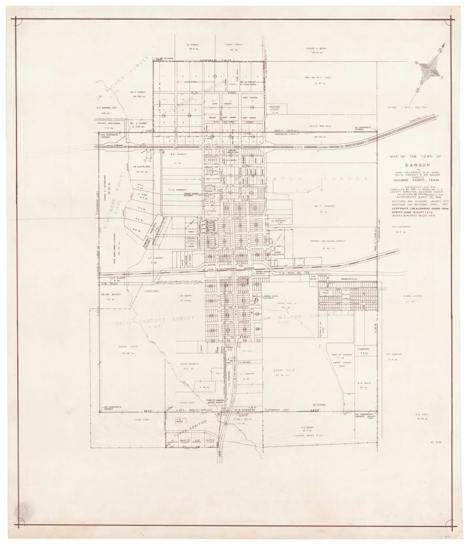
Map of the Town of Dawson in John Fullerton, G. W. Rose, David Onstott and Wm. Walker Surveys
-
Map/Doc
93672
-
Collection
General Map Collection
-
Object Dates
1975/10/29 (Creation Date)
2014/4/8 (File Date)
-
People and Organizations
William V. Mowlam (Compiler)
William V. Mowlam (Surveyor/Engineer)
-
Counties
Navarro
-
Subjects
City
-
Height x Width
43.1 x 37.1 inches
109.5 x 94.2 cm
-
Comments
Reflects revisions through October 29, 1975
Part of: General Map Collection
Johnson County

Print $20.00
- Digital $50.00
Johnson County
1857
Size 19.2 x 29.1 inches
Map/Doc 3734
Mustang Island, Nueces County, Texas

Print $20.00
- Digital $50.00
Mustang Island, Nueces County, Texas
1978
Size 40.7 x 36.2 inches
Map/Doc 2500
Right of Way and Track Map Texas & New Orleans R.R. Co. operated by the T. & N. O. R.R. Co. Dallas-Sabine Branch

Print $40.00
- Digital $50.00
Right of Way and Track Map Texas & New Orleans R.R. Co. operated by the T. & N. O. R.R. Co. Dallas-Sabine Branch
1918
Size 26.4 x 56.7 inches
Map/Doc 64157
Lamb County Sketch File 13

Print $42.00
- Digital $50.00
Lamb County Sketch File 13
1914
Size 9.1 x 8.6 inches
Map/Doc 29371
Flight Mission No. BRA-7M, Frame 151, Jefferson County

Print $20.00
- Digital $50.00
Flight Mission No. BRA-7M, Frame 151, Jefferson County
1953
Size 18.7 x 22.6 inches
Map/Doc 85545
Pecos County Sketch File U

Print $20.00
- Digital $50.00
Pecos County Sketch File U
1902
Size 20.9 x 32.7 inches
Map/Doc 12188
Presidio County Sketch File G

Print $6.00
- Digital $50.00
Presidio County Sketch File G
1913
Size 9.7 x 17.0 inches
Map/Doc 34429
Webb County Sketch File 44a

Print $20.00
- Digital $50.00
Webb County Sketch File 44a
1936
Size 29.4 x 18.2 inches
Map/Doc 12640
Winkler County Rolled Sketch 12

Print $20.00
- Digital $50.00
Winkler County Rolled Sketch 12
1965
Size 24.9 x 18.5 inches
Map/Doc 8279
Walker County Working Sketch 13

Print $20.00
- Digital $50.00
Walker County Working Sketch 13
1950
Size 18.0 x 16.6 inches
Map/Doc 72293
Jim Hogg County Rolled Sketch EJF

Print $20.00
- Digital $50.00
Jim Hogg County Rolled Sketch EJF
1937
Size 36.0 x 32.4 inches
Map/Doc 9320
National Map Company's Map of Texas showing counties, cities, towns, villages and post offices, steam and electric railways with stations and distance between stations

Print $40.00
- Digital $50.00
National Map Company's Map of Texas showing counties, cities, towns, villages and post offices, steam and electric railways with stations and distance between stations
1920
Size 50.3 x 51.1 inches
Map/Doc 10749
You may also like
Galveston County Rolled Sketch 43B

Print $20.00
- Digital $50.00
Galveston County Rolled Sketch 43B
Size 27.3 x 16.2 inches
Map/Doc 76006
Waller County Working Sketch 2

Print $20.00
- Digital $50.00
Waller County Working Sketch 2
1955
Size 19.5 x 18.8 inches
Map/Doc 72301
[I. & G. N. RR. Co. Blk. 1]
![89805, [I. & G. N. RR. Co. Blk. 1], Twichell Survey Records](https://historictexasmaps.com/wmedia_w700/maps/89805-1.tif.jpg)
Print $40.00
- Digital $50.00
[I. & G. N. RR. Co. Blk. 1]
Size 36.7 x 49.0 inches
Map/Doc 89805
Andrews County Rolled Sketch 18

Print $20.00
- Digital $50.00
Andrews County Rolled Sketch 18
1942
Size 26.0 x 31.3 inches
Map/Doc 8394
Clay County Sketch File 6

Print $4.00
- Digital $50.00
Clay County Sketch File 6
1854
Size 8.1 x 12.5 inches
Map/Doc 18395
Ochiltree County Rolled Sketch 1

Print $20.00
- Digital $50.00
Ochiltree County Rolled Sketch 1
1942
Size 29.3 x 38.8 inches
Map/Doc 9655
Tom Green County Rolled Sketch 27

Print $20.00
- Digital $50.00
Tom Green County Rolled Sketch 27
Size 36.1 x 45.4 inches
Map/Doc 10008
[Sketch of sections 33 and 34]
![91574, [Sketch of sections 33 and 34], Twichell Survey Records](https://historictexasmaps.com/wmedia_w700/maps/91574-1.tif.jpg)
Print $2.00
- Digital $50.00
[Sketch of sections 33 and 34]
Size 5.1 x 8.8 inches
Map/Doc 91574
Morris County Rolled Sketch 2A

Print $20.00
- Digital $50.00
Morris County Rolled Sketch 2A
Size 24.2 x 19.1 inches
Map/Doc 10243
Crockett County Sketch File 35c

Print $8.00
- Digital $50.00
Crockett County Sketch File 35c
Size 14.3 x 8.8 inches
Map/Doc 19746
Kendall County Working Sketch 28a

Print $20.00
- Digital $50.00
Kendall County Working Sketch 28a
2006
Size 29.8 x 45.0 inches
Map/Doc 83097
Montgomery County Working Sketch 59

Print $20.00
- Digital $50.00
Montgomery County Working Sketch 59
1962
Size 25.4 x 22.8 inches
Map/Doc 71166