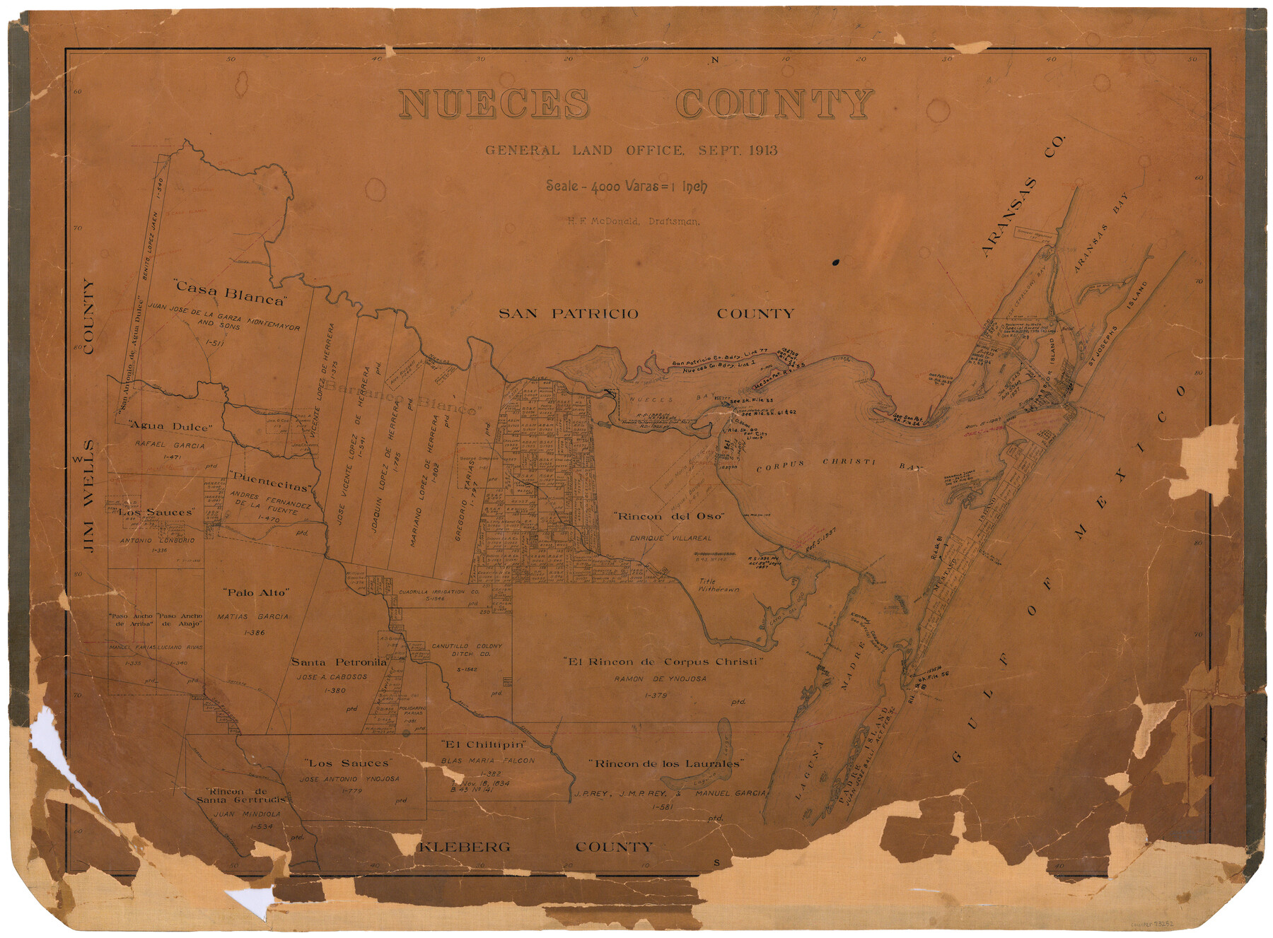
Nueces County
-
Map/Doc
73252
-
Collection
General Map Collection
-
Object Dates
1913 (Creation Date)
-
People and Organizations
Texas General Land Office (Publisher)
H.F. McDonald (Compiler)
H.F. McDonald (Draftsman)
-
Counties
Nueces
-
Subjects
County
-
Height x Width
25.9 x 34.9 inches
65.8 x 88.6 cm
-
Comments
Hand lettered.
Note on reverse side: "Compilated and drawn by H. F. McDonald. Completed September 2, 1913. Area: 1108 Square Miles." -
Features
Santa Gertrudis Creek
Shoal Bay
Ransoms Point
Paloma
Steadman Island
Harbor Island
Lydia Ann Islands
St. Josephs Island
Peñetes Creek
Murray's Island
Ship Island
Hog Island
Donnels Reef
Padre Island
South Bird Island
North Bird Island
Laguna Larga
Tranquitas Creek
Acero Creek
San Fernando Creek
Carreta Creek
Bishop
Pintas Creek
Peat Island
Aransas Pass
Shell Island
Banquette
Clarksville
Shallow Bay
Kingsville
Mud Island
Shell Point
Crane Islands
Agua Dulce
Clarkwood
Bentonville
Corpus Christi Pass
TMRR
Turtle Cove
Port Aransas
Dagger Island
Red Fish Cove
Robstown
Puente Citos
Rosita Creek
Calallen
Ingleside Cove
Gregory Junction
Casa Blanca
Orange Grove
Sandy Hollow Creek
Leon Creek
Quinto Creek
La Fruta
Nueces River
Nuecestown
Nueces Bay
Whites Point
Shamrock Point
Reynolds
Aransas Pass
Corpus Christi Bayou
Shell Bank Island
SA&AP
Fish Bay
Taylor Islands
Tally Island
Aransas Bay
Rockport
Sandia
Mud Reef
Mustang Island
Laguna Madre
Driscoll
Portland
Chiltipin Creek
Santa Petronia Creek
SLB&M
Oso Creek
Cayo del Oso
Dimmits Island
Flour Bluff Point
Gulf of Mexico
Penites Creek
Shamrock Cove
Shamrock Island
Corpus Christi Bay
McGloins Bluff
Corpus Christi
Ringon [sic] Point
Red Fish Bay
Agua Dulce Creek
San Patricio
Petronia Creek
Part of: General Map Collection
Runnels County Sketch File 6a

Print $4.00
Runnels County Sketch File 6a
1883
Size 12.9 x 8.2 inches
Map/Doc 35442
Hamilton County Working Sketch 13

Print $40.00
- Digital $50.00
Hamilton County Working Sketch 13
1949
Size 43.5 x 57.0 inches
Map/Doc 63351
Stonewall County Sketch File 17

Print $6.00
- Digital $50.00
Stonewall County Sketch File 17
1902
Size 16.5 x 10.6 inches
Map/Doc 37274
Right of Way and Track Map, the Missouri, Kansas and Texas Ry. of Texas operated by the Missouri, Kansas and Texas Ry. of Texas, San Antonio Division

Print $40.00
- Digital $50.00
Right of Way and Track Map, the Missouri, Kansas and Texas Ry. of Texas operated by the Missouri, Kansas and Texas Ry. of Texas, San Antonio Division
1918
Size 25.2 x 58.8 inches
Map/Doc 64584
Real County Working Sketch 49

Print $20.00
- Digital $50.00
Real County Working Sketch 49
1957
Size 25.9 x 25.7 inches
Map/Doc 71941
Zavala County

Print $20.00
- Digital $50.00
Zavala County
1915
Size 38.6 x 46.6 inches
Map/Doc 16940
Williamson County Rolled Sketch 5

Print $20.00
- Digital $50.00
Williamson County Rolled Sketch 5
1940
Size 23.7 x 34.5 inches
Map/Doc 8263
Ward County Working Sketch 10

Print $20.00
- Digital $50.00
Ward County Working Sketch 10
1946
Size 29.6 x 15.6 inches
Map/Doc 72316
Harris County Working Sketch 65

Print $20.00
- Digital $50.00
Harris County Working Sketch 65
1955
Size 29.5 x 28.6 inches
Map/Doc 65957
Flight Mission No. DQN-5K, Frame 147, Calhoun County

Print $20.00
- Digital $50.00
Flight Mission No. DQN-5K, Frame 147, Calhoun County
1953
Size 18.5 x 22.1 inches
Map/Doc 84422
Flight Mission No. DQO-1K, Frame 38, Galveston County

Print $20.00
- Digital $50.00
Flight Mission No. DQO-1K, Frame 38, Galveston County
1952
Size 18.0 x 17.6 inches
Map/Doc 84981
Dickens County Sketch File F1

Print $28.00
- Digital $50.00
Dickens County Sketch File F1
Size 11.4 x 8.7 inches
Map/Doc 20849
You may also like
Roberts County Working Sketch 3

Print $20.00
- Digital $50.00
Roberts County Working Sketch 3
1949
Size 18.0 x 14.3 inches
Map/Doc 63529
Flight Mission No. CLL-1N, Frame 158, Willacy County

Print $20.00
- Digital $50.00
Flight Mission No. CLL-1N, Frame 158, Willacy County
1954
Size 18.4 x 22.1 inches
Map/Doc 87049
San Saba County

Print $20.00
- Digital $50.00
San Saba County
1918
Size 23.6 x 18.4 inches
Map/Doc 78397

Crane County Sketch File 4

Print $6.00
- Digital $50.00
Crane County Sketch File 4
Size 13.6 x 10.9 inches
Map/Doc 19562
Map of Brown County

Print $20.00
- Digital $50.00
Map of Brown County
Size 25.4 x 23.5 inches
Map/Doc 3340
Brewster County Sketch File N-13

Print $8.00
- Digital $50.00
Brewster County Sketch File N-13
1935
Size 14.3 x 8.7 inches
Map/Doc 15625
Morris County Rolled Sketch 2A

Print $20.00
- Digital $50.00
Morris County Rolled Sketch 2A
Size 24.5 x 19.4 inches
Map/Doc 10248

Texas Land Commissioner George P. Bush's Energy Map of Texas Showing Significant Events and Well & Pipeline Locations Between 1543 and 2015

Print $20.00
- Digital $50.00
Texas Land Commissioner George P. Bush's Energy Map of Texas Showing Significant Events and Well & Pipeline Locations Between 1543 and 2015
2015
Size 33.3 x 36.3 inches
Map/Doc 93978
A Plat of 23 Miles of the Colorado River
![65651, [Sketch for Mineral Application 1742], General Map Collection](https://historictexasmaps.com/wmedia_w700/maps/65651.tif.jpg)
Print $40.00
- Digital $50.00
A Plat of 23 Miles of the Colorado River
1918
Size 38.3 x 56.7 inches
Map/Doc 65651
Bowie County Working Sketch 19

Print $20.00
- Digital $50.00
Bowie County Working Sketch 19
1962
Size 23.3 x 17.9 inches
Map/Doc 67423