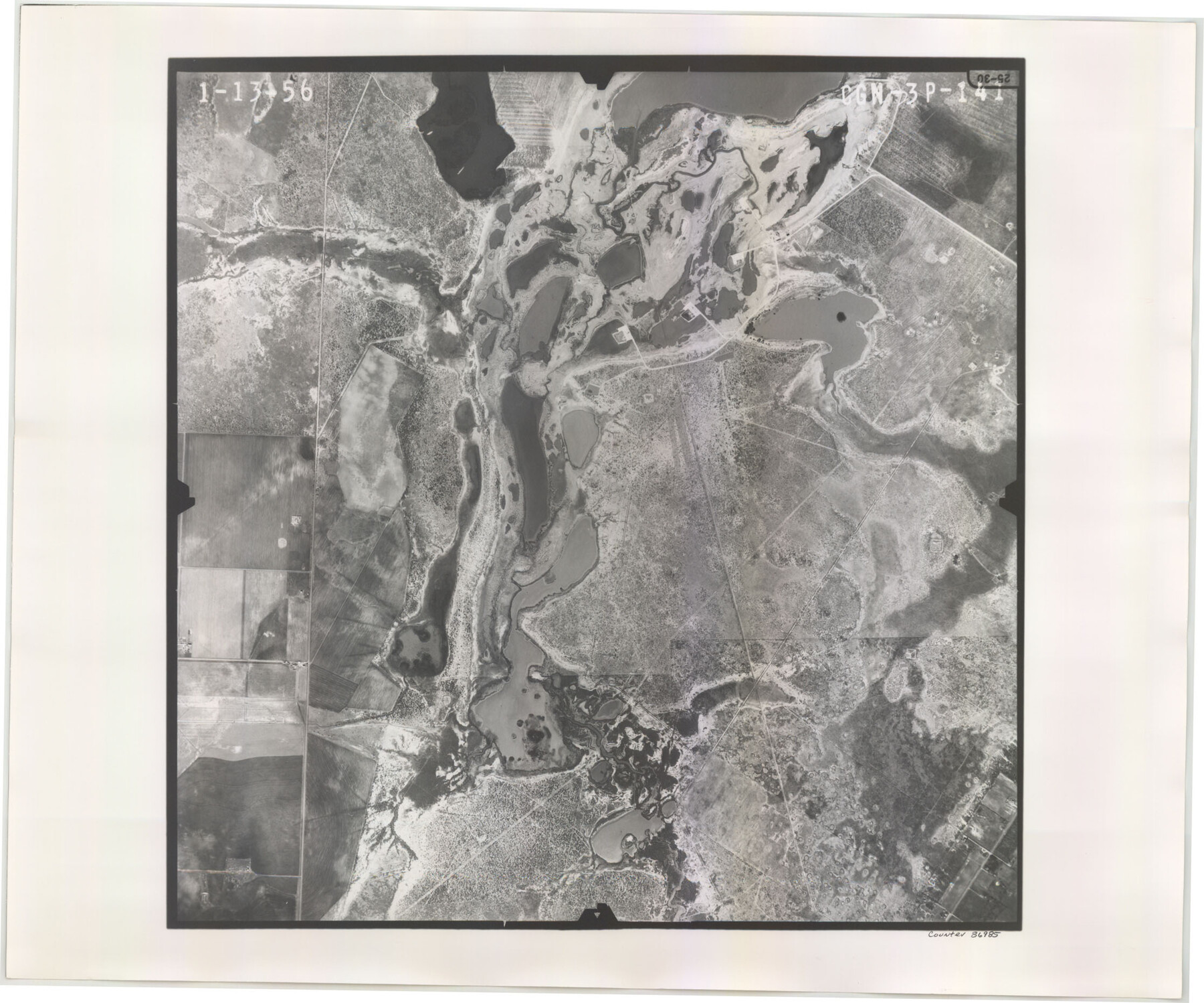
Flight Mission No. CGN-3P, Frame 141, San Patricio County
CGN-3P-141
-
Map/Doc
86985
-
Collection
General Map Collection
-
Object Dates
1956/1/13 (Creation Date)
-
People and Organizations
U. S. Department of Agriculture (Publisher)
-
Counties
San Patricio
-
Subjects
Aerial Photograph
-
Height x Width
18.6 x 22.4 inches
47.2 x 56.9 cm
-
Comments
Flown by V. L. Beavers and Associates of San Antonio, Texas.
Part of: General Map Collection
San Jacinto County Sketch File 23

Print $26.00
San Jacinto County Sketch File 23
1993
Size 14.6 x 8.8 inches
Map/Doc 35803
Flight Mission No. DIX-8P, Frame 89, Aransas County

Print $20.00
- Digital $50.00
Flight Mission No. DIX-8P, Frame 89, Aransas County
1956
Size 18.7 x 22.4 inches
Map/Doc 83914
Flight Mission No. DQO-6K, Frame 32, Galveston County

Print $20.00
- Digital $50.00
Flight Mission No. DQO-6K, Frame 32, Galveston County
1952
Size 18.7 x 22.4 inches
Map/Doc 85098
Titus County Boundary File 3

Print $6.00
- Digital $50.00
Titus County Boundary File 3
Size 7.6 x 6.9 inches
Map/Doc 59300
Harris County Sketch File 29

Print $15.00
- Digital $50.00
Harris County Sketch File 29
Size 14.1 x 9.0 inches
Map/Doc 25409
Pecos County Working Sketch 42

Print $20.00
- Digital $50.00
Pecos County Working Sketch 42
1942
Size 31.3 x 23.9 inches
Map/Doc 71514
Edwards County Working Sketch 128

Print $20.00
- Digital $50.00
Edwards County Working Sketch 128
1981
Size 26.5 x 32.4 inches
Map/Doc 69004
[Surveys along the Trinity River]
![321, [Surveys along the Trinity River], General Map Collection](https://historictexasmaps.com/wmedia_w700/maps/321.tif.jpg)
Print $2.00
- Digital $50.00
[Surveys along the Trinity River]
Size 3.6 x 3.7 inches
Map/Doc 321
[Surveys near the Guadalupe River]
![288, [Surveys near the Guadalupe River], General Map Collection](https://historictexasmaps.com/wmedia_w700/maps/288.tif.jpg)
Print $2.00
- Digital $50.00
[Surveys near the Guadalupe River]
1847
Size 8.8 x 7.9 inches
Map/Doc 288
Flight Mission No. DQO-8K, Frame 40, Galveston County

Print $20.00
- Digital $50.00
Flight Mission No. DQO-8K, Frame 40, Galveston County
1952
Size 18.5 x 22.3 inches
Map/Doc 85147
Jeff Davis County Rolled Sketch 32

Print $20.00
- Digital $50.00
Jeff Davis County Rolled Sketch 32
1984
Size 16.3 x 24.5 inches
Map/Doc 7721
1988 Land Use - El Paso, Ciudad Juarez and Vicinity

Print $20.00
- Digital $50.00
1988 Land Use - El Paso, Ciudad Juarez and Vicinity
1988
Size 34.2 x 25.1 inches
Map/Doc 87369
You may also like
[Surveys in Austin's Colony by Horatio Chriesman along Mill and Cummins Creeks]
![68, [Surveys in Austin's Colony by Horatio Chriesman along Mill and Cummins Creeks], General Map Collection](https://historictexasmaps.com/wmedia_w700/maps/68.tif.jpg)
Print $20.00
- Digital $50.00
[Surveys in Austin's Colony by Horatio Chriesman along Mill and Cummins Creeks]
1830
Size 30.7 x 25.7 inches
Map/Doc 68
Crockett County Rolled Sketch 30

Print $20.00
- Digital $50.00
Crockett County Rolled Sketch 30
1934
Size 24.5 x 43.1 inches
Map/Doc 8700
Ector County Working Sketch 4

Print $20.00
- Digital $50.00
Ector County Working Sketch 4
1940
Size 25.8 x 30.0 inches
Map/Doc 68847
Concho County Sketch File 22

Print $20.00
- Digital $50.00
Concho County Sketch File 22
Size 24.9 x 18.1 inches
Map/Doc 11155
Wilson County Working Sketch 6

Print $20.00
- Digital $50.00
Wilson County Working Sketch 6
1955
Size 39.4 x 32.3 inches
Map/Doc 72586
Flight Mission No. DCL-5C, Frame 4, Kenedy County

Print $20.00
- Digital $50.00
Flight Mission No. DCL-5C, Frame 4, Kenedy County
1943
Size 18.6 x 22.5 inches
Map/Doc 85829
El Paso County Boundary File 9

Print $14.00
- Digital $50.00
El Paso County Boundary File 9
Size 12.7 x 8.2 inches
Map/Doc 53111
Fort Bend County Rolled Sketch 30 1/2

Print $20.00
- Digital $50.00
Fort Bend County Rolled Sketch 30 1/2
Size 20.1 x 26.5 inches
Map/Doc 5902
Gray County Rolled Sketch 3

Print $105.00
- Digital $50.00
Gray County Rolled Sketch 3
Size 10.6 x 15.5 inches
Map/Doc 45287
Map of Childress, Childress County, Texas on the Line of the Fort Worth and Denver City Railway, Texas Pan-Handle Route

Print $20.00
- Digital $50.00
Map of Childress, Childress County, Texas on the Line of the Fort Worth and Denver City Railway, Texas Pan-Handle Route
1888
Size 35.6 x 28.0 inches
Map/Doc 7691
Pecos County Working Sketch 117

Print $40.00
- Digital $50.00
Pecos County Working Sketch 117
1973
Size 57.7 x 36.8 inches
Map/Doc 71590
Map showing connection and conflict of Block 8, G. H. & S. A. Ry. with Block II, T. & P. Ry. Co.

Print $20.00
- Digital $50.00
Map showing connection and conflict of Block 8, G. H. & S. A. Ry. with Block II, T. & P. Ry. Co.
Size 25.5 x 33.2 inches
Map/Doc 91821