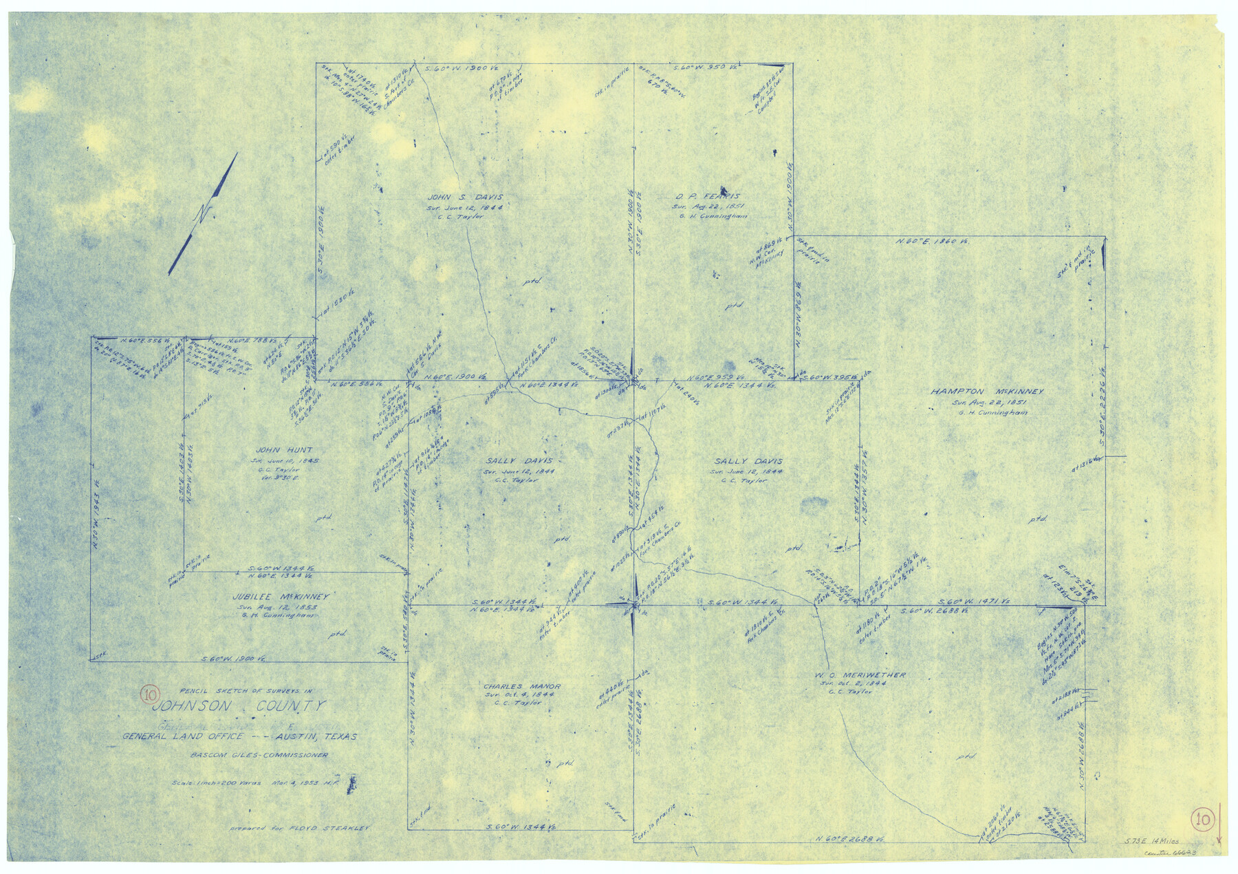
Johnson County Working Sketch 10
-
Map/Doc
66623
-
Collection
General Map Collection
-
Object Dates
3/4/1953 (Creation Date)
-
People and Organizations
Herman Forbes (Draftsman)
-
Counties
Johnson
-
Subjects
Surveying Working Sketch
-
Height x Width
26.2 x 37.1 inches
66.6 x 94.2 cm
-
Scale
1" = 200 varas
Part of: General Map Collection
Zavala County Sketch File 21

Print $4.00
- Digital $50.00
Zavala County Sketch File 21
1915
Size 11.5 x 8.8 inches
Map/Doc 41376
Hardin County Rolled Sketch 21

Print $20.00
- Digital $50.00
Hardin County Rolled Sketch 21
1966
Size 18.8 x 22.7 inches
Map/Doc 6090
Map of Crockett County

Print $40.00
- Digital $50.00
Map of Crockett County
1878
Size 62.5 x 51.1 inches
Map/Doc 93372
Nueces County NRC Article 33.136 Sketch 15

Print $40.00
- Digital $50.00
Nueces County NRC Article 33.136 Sketch 15
2012
Size 18.0 x 24.0 inches
Map/Doc 93357
[Right of Way Map, Belton Branch of the M.K.&T. RR.]
![64227, [Right of Way Map, Belton Branch of the M.K.&T. RR.], General Map Collection](https://historictexasmaps.com/wmedia_w700/maps/64227.tif.jpg)
Print $20.00
- Digital $50.00
[Right of Way Map, Belton Branch of the M.K.&T. RR.]
1896
Size 22.0 x 7.2 inches
Map/Doc 64227
[Fort Worth & Rio Grande Ry.]
![64354, [Fort Worth & Rio Grande Ry.], General Map Collection](https://historictexasmaps.com/wmedia_w700/maps/64354.tif.jpg)
Print $20.00
- Digital $50.00
[Fort Worth & Rio Grande Ry.]
Size 15.2 x 43.0 inches
Map/Doc 64354
Concho County Sketch File 8

Print $44.00
- Digital $50.00
Concho County Sketch File 8
1886
Size 16.2 x 12.2 inches
Map/Doc 19131
Hardin County Sketch File 5

Print $5.00
- Digital $50.00
Hardin County Sketch File 5
1856
Size 9.0 x 6.6 inches
Map/Doc 25092
Crockett County Sketch File 67

Print $20.00
- Digital $50.00
Crockett County Sketch File 67
1927
Size 30.1 x 26.6 inches
Map/Doc 11231
Johnson County Sketch File 5

Print $20.00
- Digital $50.00
Johnson County Sketch File 5
1874
Size 33.3 x 14.3 inches
Map/Doc 11890
Fort Bend County Rolled Sketch T

Print $20.00
- Digital $50.00
Fort Bend County Rolled Sketch T
1930
Size 28.7 x 25.8 inches
Map/Doc 5908
Interfaith's Official Map: The Woodlands, a real hometown for people and companies

Interfaith's Official Map: The Woodlands, a real hometown for people and companies
1997
Size 36.7 x 22.5 inches
Map/Doc 94285
You may also like
Mitchell County

Print $20.00
- Digital $50.00
Mitchell County
1922
Size 43.4 x 38.2 inches
Map/Doc 66936
Irion County Working Sketch 10

Print $20.00
- Digital $50.00
Irion County Working Sketch 10
1940
Size 29.6 x 43.5 inches
Map/Doc 66419
Edwards County Working Sketch 73

Print $20.00
- Digital $50.00
Edwards County Working Sketch 73
1958
Size 30.4 x 27.0 inches
Map/Doc 68949
Flight Mission No. CUG-1P, Frame 22, Kleberg County

Print $20.00
- Digital $50.00
Flight Mission No. CUG-1P, Frame 22, Kleberg County
1956
Size 18.7 x 22.1 inches
Map/Doc 86112
From Citizens of Montgomery and Washington Counties to Redefine the Boundary Between Their Two Counties, Undated

Print $20.00
From Citizens of Montgomery and Washington Counties to Redefine the Boundary Between Their Two Counties, Undated
2020
Size 15.0 x 21.7 inches
Map/Doc 96402
Mitchell County Boundary File 1c

Print $12.00
- Digital $50.00
Mitchell County Boundary File 1c
Size 8.7 x 12.3 inches
Map/Doc 57361
General Highway Map, Karnes County, Texas

Print $20.00
General Highway Map, Karnes County, Texas
1940
Size 18.3 x 24.7 inches
Map/Doc 79151
Denton County Boundary File 4 and 4a and 4b and 4c

Print $14.00
- Digital $50.00
Denton County Boundary File 4 and 4a and 4b and 4c
Size 11.2 x 8.5 inches
Map/Doc 52441
Brewster County Rolled Sketch 19A

Print $20.00
- Digital $50.00
Brewster County Rolled Sketch 19A
1881
Size 31.5 x 38.6 inches
Map/Doc 8471
Val Verde County Working Sketch 109

Print $20.00
- Digital $50.00
Val Verde County Working Sketch 109
1988
Size 41.4 x 31.2 inches
Map/Doc 72244
Kimble County Working Sketch 27

Print $20.00
- Digital $50.00
Kimble County Working Sketch 27
1934
Size 16.1 x 17.3 inches
Map/Doc 70095
Old Miscellaneous File 10

Print $4.00
- Digital $50.00
Old Miscellaneous File 10
Size 9.6 x 8.2 inches
Map/Doc 75435