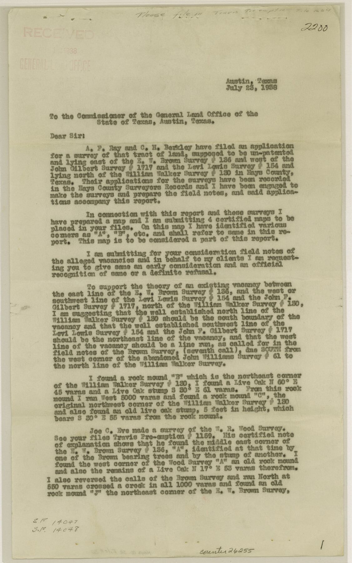
Hays County Sketch File 30
[Statement of Orin E. Metalfe]
-
Map/Doc
26255
-
Collection
General Map Collection
-
Object Dates
7/23/1938 (Creation Date)
8/12/1938 (File Date)
7/23/1938 (Correspondence Date)
4/25/1839 (Survey Date)
5/31/1882 (Survey Date)
6/6/1847 (Survey Date)
-
People and Organizations
Orin E. Metcalfe (Surveyor/Engineer)
William S. Wallace (Surveyor/Engineer)
Joe C. Eve (Surveyor/Engineer)
James R. Pace (Surveyor/Engineer)
-
Counties
Hays
-
Subjects
Surveying Sketch File
-
Height x Width
14.3 x 9.0 inches
36.3 x 22.9 cm
-
Medium
paper, print
Part of: General Map Collection
Kleberg County Boundary File 4

Print $22.00
- Digital $50.00
Kleberg County Boundary File 4
Size 14.2 x 8.6 inches
Map/Doc 64986
Brazoria County Sketch File 16

Print $16.00
- Digital $50.00
Brazoria County Sketch File 16
1893
Size 9.4 x 4.3 inches
Map/Doc 14981
Flight Mission No. DCL-6C, Frame 4, Kenedy County

Print $20.00
- Digital $50.00
Flight Mission No. DCL-6C, Frame 4, Kenedy County
1943
Size 18.7 x 22.3 inches
Map/Doc 85864
Clay County Sketch File 21

Print $2.00
- Digital $50.00
Clay County Sketch File 21
1882
Size 11.3 x 8.7 inches
Map/Doc 18435
Pecos County Rolled Sketch 103A

Print $20.00
- Digital $50.00
Pecos County Rolled Sketch 103A
1940
Size 29.3 x 33.4 inches
Map/Doc 7252
Travis County Rolled Sketch 29

Print $20.00
- Digital $50.00
Travis County Rolled Sketch 29
1946
Size 25.1 x 37.8 inches
Map/Doc 8031
Uvalde County Working Sketch 64, revised

Print $20.00
- Digital $50.00
Uvalde County Working Sketch 64, revised
1998
Size 34.2 x 35.5 inches
Map/Doc 72135
Flight Mission No. BRE-2P, Frame 63, Nueces County

Print $20.00
- Digital $50.00
Flight Mission No. BRE-2P, Frame 63, Nueces County
1956
Size 18.5 x 22.5 inches
Map/Doc 86758

Pecos County Rolled Sketch 71

Print $20.00
- Digital $50.00
Pecos County Rolled Sketch 71
Size 21.9 x 47.6 inches
Map/Doc 9703
Map showing the environs of Brazos Islnd. Texas

Print $20.00
- Digital $50.00
Map showing the environs of Brazos Islnd. Texas
1864
Size 26.2 x 18.2 inches
Map/Doc 72914
Kimble County Working Sketch 79

Print $20.00
- Digital $50.00
Kimble County Working Sketch 79
1971
Size 34.7 x 31.9 inches
Map/Doc 70147
You may also like
Comment on Illustrations [SMS Ranch Booklet]
![96594, Comment on Illustrations [SMS Ranch Booklet], Cobb Digital Map Collection](https://historictexasmaps.com/wmedia_w700/pdf_converted_jpg/qi_pdf_thumbnail_40597.jpg)
Comment on Illustrations [SMS Ranch Booklet]
1916
Size 6.1 x 9.2 inches
Map/Doc 96594
Morris County Rolled Sketch 2A

Print $20.00
- Digital $50.00
Morris County Rolled Sketch 2A
Size 13.4 x 19.1 inches
Map/Doc 10231
Padre Island National Seashore

Print $4.00
- Digital $50.00
Padre Island National Seashore
Size 15.9 x 22.3 inches
Map/Doc 60539
Kimble County Working Sketch 7

Print $20.00
- Digital $50.00
Kimble County Working Sketch 7
1917
Size 12.6 x 16.8 inches
Map/Doc 70075
Fort Bend County Working Sketch 19

Print $20.00
- Digital $50.00
Fort Bend County Working Sketch 19
1959
Size 26.3 x 29.9 inches
Map/Doc 69225
Montague County Sketch File 15

Print $6.00
- Digital $50.00
Montague County Sketch File 15
1880
Size 11.0 x 15.1 inches
Map/Doc 31742
Navigation Maps of Gulf Intracoastal Waterway, Port Arthur to Brownsville, Texas

Print $4.00
- Digital $50.00
Navigation Maps of Gulf Intracoastal Waterway, Port Arthur to Brownsville, Texas
1951
Size 16.6 x 21.5 inches
Map/Doc 65440
Flight Mission No. BQR-14K, Frame 37, Brazoria County

Print $20.00
- Digital $50.00
Flight Mission No. BQR-14K, Frame 37, Brazoria County
1952
Size 18.6 x 22.2 inches
Map/Doc 84094
Orange County Rolled Sketch 19A

Print $20.00
- Digital $50.00
Orange County Rolled Sketch 19A
1945
Size 17.3 x 24.7 inches
Map/Doc 7184
Freestone County Sketch File 14

Print $4.00
- Digital $50.00
Freestone County Sketch File 14
1861
Size 13.0 x 8.2 inches
Map/Doc 23065
Cherokee County Sketch File 20

Print $4.00
- Digital $50.00
Cherokee County Sketch File 20
1876
Size 8.2 x 6.0 inches
Map/Doc 18163
Flight Mission No. DQN-5K, Frame 60, Calhoun County

Print $20.00
- Digital $50.00
Flight Mission No. DQN-5K, Frame 60, Calhoun County
1953
Size 15.5 x 15.4 inches
Map/Doc 84403