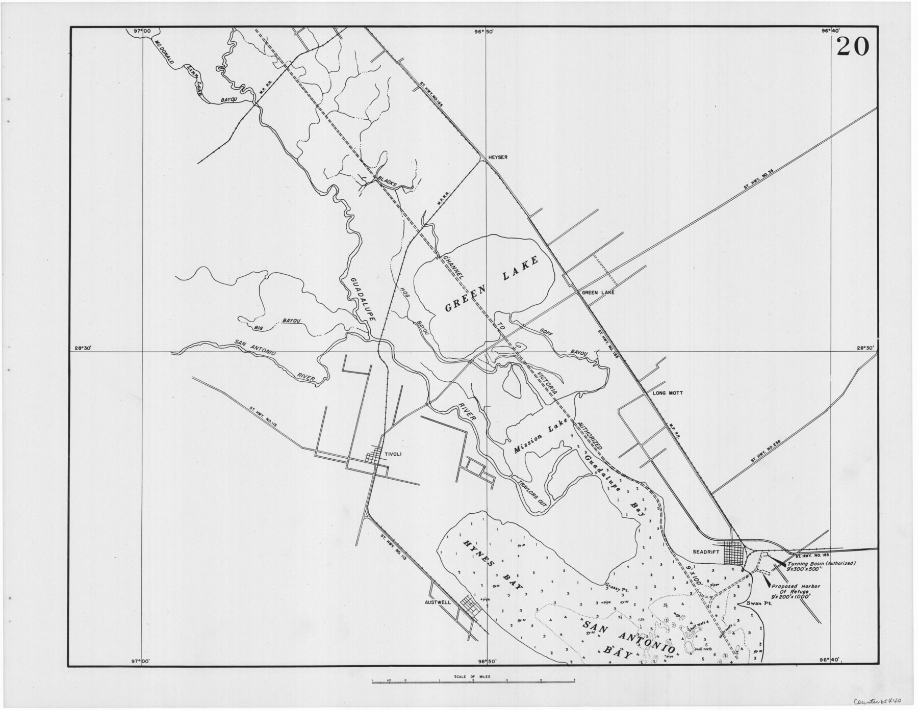
Navigation Maps of Gulf Intracoastal Waterway, Port Arthur to Brownsville, Texas
K-7-68
-
Map/Doc
65440
-
Collection
General Map Collection
-
Object Dates
1951 (Creation Date)
-
People and Organizations
Corps of Engineers (Publisher)
-
Counties
Calhoun Refugio
-
Subjects
Intracoastal Waterways
-
Height x Width
16.6 x 21.5 inches
42.2 x 54.6 cm
Part of: General Map Collection
[Atlas C, Table of Contents]
![78353, [Atlas C, Table of Contents], General Map Collection](https://historictexasmaps.com/wmedia_w700/maps/78353.tif.jpg)
Print $3.00
- Digital $50.00
[Atlas C, Table of Contents]
Size 14.7 x 9.6 inches
Map/Doc 78353
Colorado County Sketch File 14

Print $8.00
- Digital $50.00
Colorado County Sketch File 14
1874
Size 12.8 x 8.0 inches
Map/Doc 18939
Burnet County Sketch File 12

Print $4.00
- Digital $50.00
Burnet County Sketch File 12
1848
Size 12.6 x 7.5 inches
Map/Doc 16694
Field Notes of Surveys in Travis District (Callahan, Coleman, and Runnels Counties)

Field Notes of Surveys in Travis District (Callahan, Coleman, and Runnels Counties)
Map/Doc 81675
Austin County Sketch File 3

Print $40.00
- Digital $50.00
Austin County Sketch File 3
Size 17.1 x 13.6 inches
Map/Doc 10870

Pecos County Rolled Sketch 132

Print $20.00
- Digital $50.00
Pecos County Rolled Sketch 132
Size 32.8 x 38.9 inches
Map/Doc 9728
Hemphill County

Print $20.00
- Digital $50.00
Hemphill County
1932
Size 39.9 x 36.6 inches
Map/Doc 73177
Refugio County Sketch File 3

Print $8.00
- Digital $50.00
Refugio County Sketch File 3
1849
Size 12.9 x 8.6 inches
Map/Doc 35241
Liberty County Working Sketch 45

Print $20.00
- Digital $50.00
Liberty County Working Sketch 45
1953
Size 28.9 x 39.8 inches
Map/Doc 70504
Calhoun County NRC Article 33.136 Sketch 6

Print $24.00
- Digital $50.00
Calhoun County NRC Article 33.136 Sketch 6
2014
Size 18.0 x 24.0 inches
Map/Doc 94462
Freestone County

Print $40.00
- Digital $50.00
Freestone County
1988
Size 49.0 x 43.4 inches
Map/Doc 95502
You may also like
Irion County Working Sketch 6

Print $20.00
- Digital $50.00
Irion County Working Sketch 6
1935
Size 16.6 x 30.8 inches
Map/Doc 66415

Flight Mission No. BQR-14K, Frame 36, Brazoria County

Print $20.00
- Digital $50.00
Flight Mission No. BQR-14K, Frame 36, Brazoria County
1952
Size 18.6 x 22.3 inches
Map/Doc 84093
Raymond Marshall Farm

Print $3.00
- Digital $50.00
Raymond Marshall Farm
Size 9.8 x 12.6 inches
Map/Doc 92310
Carson County Sketch File 1

Print $20.00
- Digital $50.00
Carson County Sketch File 1
Size 16.8 x 18.5 inches
Map/Doc 11053
Travis County Sketch File 43

Print $30.00
- Digital $50.00
Travis County Sketch File 43
1887
Size 8.8 x 9.3 inches
Map/Doc 38359
Trinity County Working Sketch 25

Print $20.00
- Digital $50.00
Trinity County Working Sketch 25
2010
Size 39.7 x 28.7 inches
Map/Doc 89600
Hidalgo County Working Sketch 4

Print $20.00
- Digital $50.00
Hidalgo County Working Sketch 4
1938
Size 43.1 x 39.6 inches
Map/Doc 66181
Hemphill County, State of Texas

Print $20.00
- Digital $50.00
Hemphill County, State of Texas
1888
Size 22.0 x 17.4 inches
Map/Doc 6187
Working Sketch Cochran and Yoakum Co's.

Print $40.00
- Digital $50.00
Working Sketch Cochran and Yoakum Co's.
1919
Size 54.2 x 14.5 inches
Map/Doc 89678
Dimmit County Working Sketch 44

Print $20.00
- Digital $50.00
Dimmit County Working Sketch 44
1979
Size 31.7 x 34.0 inches
Map/Doc 68705
Scraped-Out Division of the Slaughter Ranch Cochran County, Texas

Print $20.00
- Digital $50.00
Scraped-Out Division of the Slaughter Ranch Cochran County, Texas
1936
Size 20.1 x 22.1 inches
Map/Doc 92485