Hardin County Sketch File 9a
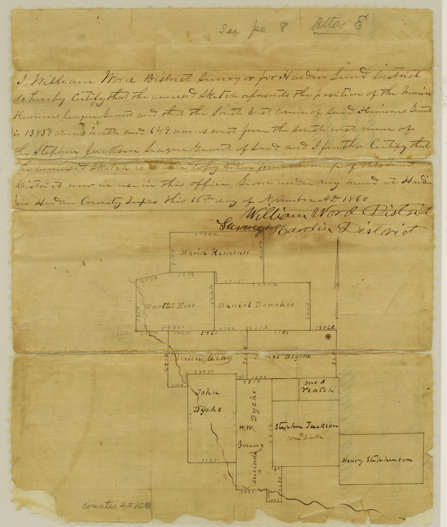
[Sketch and explanation of surveys in southern part of county]
-
Map/Doc
25108
-
Collection
General Map Collection
-
Object Dates
1860/11/16 (Creation Date)
1861/1/3 (File Date)
-
People and Organizations
William Word (Surveyor/Engineer)
-
Counties
Hardin
-
Subjects
Surveying Sketch File
-
Height x Width
9.9 x 8.4 inches
25.1 x 21.3 cm
-
Medium
paper, manuscript
Part of: General Map Collection
Hartley County Rolled Sketch 8

Print $20.00
- Digital $50.00
Hartley County Rolled Sketch 8
1974
Size 20.0 x 23.7 inches
Map/Doc 6162
Hansford County Boundary File 4

Print $26.00
- Digital $50.00
Hansford County Boundary File 4
Size 14.1 x 8.7 inches
Map/Doc 54279
Jeff Davis County Working Sketch 16

Print $20.00
- Digital $50.00
Jeff Davis County Working Sketch 16
1954
Size 19.4 x 17.3 inches
Map/Doc 66511
Hudspeth County Sketch File 21

Print $40.00
- Digital $50.00
Hudspeth County Sketch File 21
Size 60.1 x 38.0 inches
Map/Doc 10495
Gaines County Rolled Sketch 34

Print $20.00
- Digital $50.00
Gaines County Rolled Sketch 34
2002
Size 20.1 x 22.3 inches
Map/Doc 77533
Current Miscellaneous File 64

Print $12.00
- Digital $50.00
Current Miscellaneous File 64
1954
Size 10.8 x 8.5 inches
Map/Doc 74103
Hemphill County Working Sketch 31

Print $20.00
- Digital $50.00
Hemphill County Working Sketch 31
1974
Size 38.8 x 41.1 inches
Map/Doc 66126
Guadalupe County Sketch File 7b

Print $4.00
- Digital $50.00
Guadalupe County Sketch File 7b
Size 7.3 x 10.9 inches
Map/Doc 24670
Wheeler County Rolled Sketch 2

Print $20.00
- Digital $50.00
Wheeler County Rolled Sketch 2
1941
Size 44.0 x 22.4 inches
Map/Doc 10137
Crockett County Rolled Sketch 46C

Print $20.00
- Digital $50.00
Crockett County Rolled Sketch 46C
1954
Size 25.3 x 31.6 inches
Map/Doc 5782
Chambers County Sketch File 39

Print $52.00
- Digital $50.00
Chambers County Sketch File 39
Size 11.0 x 6.6 inches
Map/Doc 17652
Hays County Sketch File 16

Print $4.00
- Digital $50.00
Hays County Sketch File 16
1857
Size 12.8 x 8.3 inches
Map/Doc 26227
You may also like
Bastrop County Working Sketch 3

Print $20.00
- Digital $50.00
Bastrop County Working Sketch 3
1921
Size 22.9 x 15.4 inches
Map/Doc 67303
Flight Mission No. CGI-1N, Frame 180, Cameron County

Print $20.00
- Digital $50.00
Flight Mission No. CGI-1N, Frame 180, Cameron County
1955
Size 18.5 x 22.2 inches
Map/Doc 84515
Map of the County of Cameron, Texas

Print $40.00
- Digital $50.00
Map of the County of Cameron, Texas
1884
Size 54.7 x 34.5 inches
Map/Doc 3141
Map of the country adjacent to the left bank of the Rio Grande below Matamoros

Print $20.00
- Digital $50.00
Map of the country adjacent to the left bank of the Rio Grande below Matamoros
1847
Size 18.3 x 27.5 inches
Map/Doc 72870
Midland County Working Sketch 20

Print $20.00
- Digital $50.00
Midland County Working Sketch 20
1953
Size 22.0 x 14.9 inches
Map/Doc 71001
[Stephen F. Austin's Map of Texas]
![95825, [Stephen F. Austin's Map of Texas], Non-GLO Digital Images](https://historictexasmaps.com/wmedia_w700/maps/95825.tif.jpg)
[Stephen F. Austin's Map of Texas]
1829
Size 21.7 x 17.9 inches
Map/Doc 95825
Gregg County Working Sketch 10

Print $20.00
- Digital $50.00
Gregg County Working Sketch 10
1939
Size 34.1 x 26.4 inches
Map/Doc 63276
Flight Mission No. BRA-16M, Frame 113, Jefferson County

Print $20.00
- Digital $50.00
Flight Mission No. BRA-16M, Frame 113, Jefferson County
1953
Size 18.5 x 22.2 inches
Map/Doc 85723
Upshur County Sketch File 2a

Print $4.00
- Digital $50.00
Upshur County Sketch File 2a
Size 12.9 x 8.2 inches
Map/Doc 38734

[Gunter & Munson Maddox Bros. & Anderson Blocks F, O, N, A and vicinity]
![93203, [Gunter & Munson Maddox Bros. & Anderson Blocks F, O, N, A and vicinity], Twichell Survey Records](https://historictexasmaps.com/wmedia_w700/maps/93203-1.tif.jpg)
Print $40.00
- Digital $50.00
[Gunter & Munson Maddox Bros. & Anderson Blocks F, O, N, A and vicinity]
1929
Size 81.0 x 15.2 inches
Map/Doc 93203
Hudspeth County Rolled Sketch 70

Print $40.00
- Digital $50.00
Hudspeth County Rolled Sketch 70
1982
Size 38.1 x 47.7 inches
Map/Doc 9233