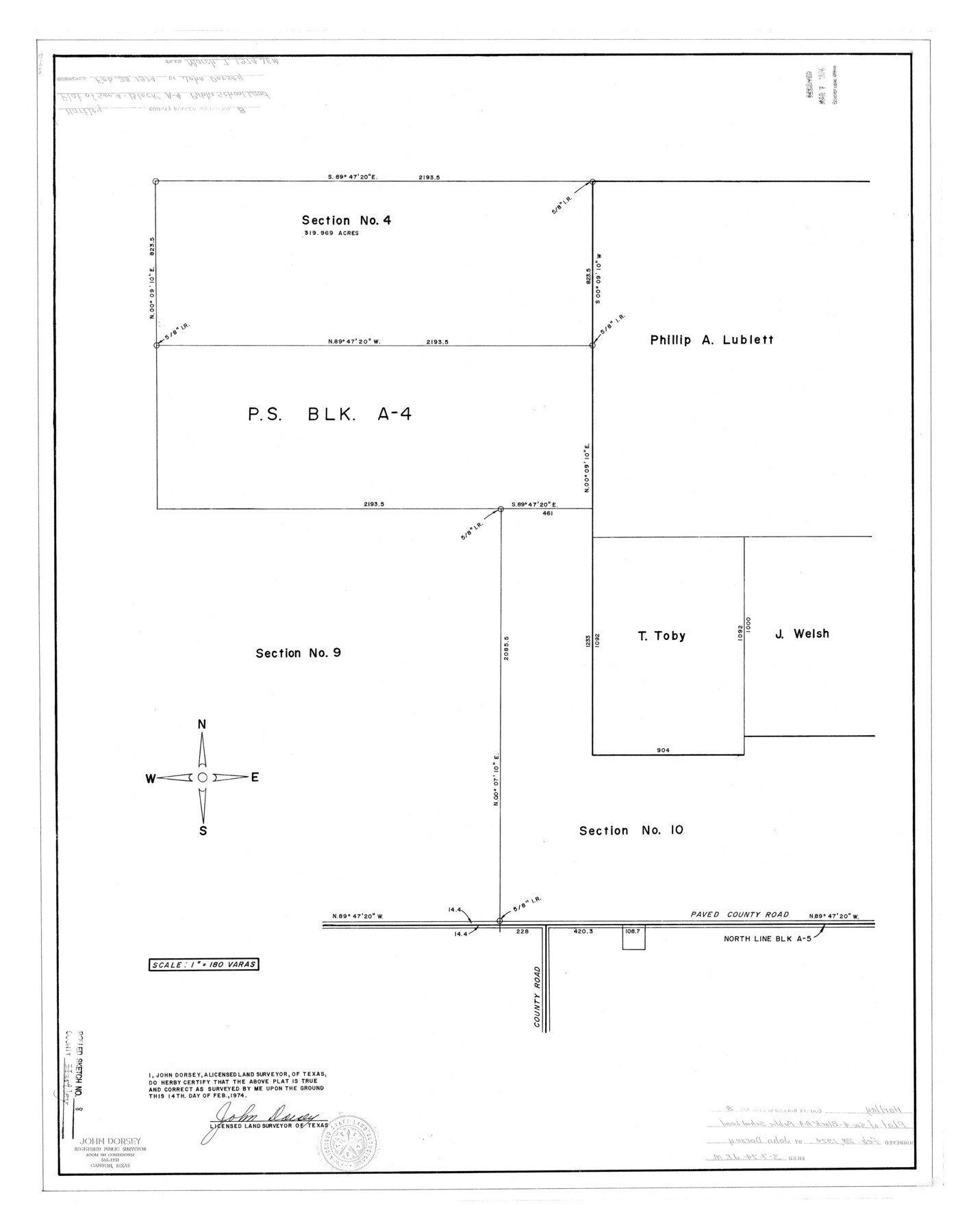
Hartley County Rolled Sketch 8
[Plat of section 4, Block A-4, Public School Land]
-
Map/Doc
6162
-
Collection
General Map Collection
-
Object Dates
2/14/1974 (Creation Date)
3/7/1974 (File Date)
-
People and Organizations
John Dorsey (Surveyor/Engineer)
-
Counties
Hartley
-
Subjects
Surveying Rolled Sketch
-
Height x Width
20.0 x 23.7 inches
50.8 x 60.2 cm
-
Scale
1" = 180 varas
Part of: General Map Collection
San Augustine County Working Sketch 9

Print $20.00
- Digital $50.00
San Augustine County Working Sketch 9
1935
Size 41.2 x 39.7 inches
Map/Doc 63696
Genl. Austins Map of Texas With Parts of the Adjoining States

Print $20.00
- Digital $50.00
Genl. Austins Map of Texas With Parts of the Adjoining States
1840
Size 28.5 x 23.4 inches
Map/Doc 2116
Map of the country adjacent to the left bank of the Rio Grande below Matamoros

Print $20.00
- Digital $50.00
Map of the country adjacent to the left bank of the Rio Grande below Matamoros
1847
Size 18.3 x 28.2 inches
Map/Doc 72871

Gillespie County Sketch File 9

Print $4.00
- Digital $50.00
Gillespie County Sketch File 9
1873
Size 8.2 x 10.5 inches
Map/Doc 24145
Flight Mission No. CUG-3P, Frame 192, Kleberg County

Print $20.00
- Digital $50.00
Flight Mission No. CUG-3P, Frame 192, Kleberg County
1956
Size 18.4 x 22.2 inches
Map/Doc 86296
Travis County Sketch File ABC

Print $20.00
- Digital $50.00
Travis County Sketch File ABC
Size 23.8 x 19.0 inches
Map/Doc 12480

Val Verde County Rolled Sketch 73

Print $20.00
- Digital $50.00
Val Verde County Rolled Sketch 73
1960
Size 15.0 x 19.4 inches
Map/Doc 8136
Montgomery County Working Sketch 18

Print $20.00
- Digital $50.00
Montgomery County Working Sketch 18
1935
Size 34.0 x 39.1 inches
Map/Doc 71125
Dimmit County Sketch File 59

Print $26.00
- Digital $50.00
Dimmit County Sketch File 59
1912
Size 14.4 x 8.9 inches
Map/Doc 21193

You may also like
Right of Way and Track Map, Houston & Texas Central R.R. operated by the T. and N. O. R.R., Fort Worth Branch

Print $40.00
- Digital $50.00
Right of Way and Track Map, Houston & Texas Central R.R. operated by the T. and N. O. R.R., Fort Worth Branch
1918
Size 31.6 x 57.2 inches
Map/Doc 64780
Childress County Working Sketch 5

Print $20.00
- Digital $50.00
Childress County Working Sketch 5
1948
Size 19.6 x 23.5 inches
Map/Doc 68021
K&E Leroy Lettering Set - 3240

K&E Leroy Lettering Set - 3240
1944
Size 1.8 x 15.5 inches
Map/Doc 97314
West End of Copano Bay and Town of Saint Marys, Texas

Print $40.00
- Digital $50.00
West End of Copano Bay and Town of Saint Marys, Texas
1861
Size 54.5 x 32.9 inches
Map/Doc 73428
Culberson County Sketch File 23

Print $10.00
- Digital $50.00
Culberson County Sketch File 23
1938
Size 14.2 x 8.6 inches
Map/Doc 20238
Aransas County Rolled Sketch 35

Print $40.00
- Digital $50.00
Aransas County Rolled Sketch 35
2006
Size 37.5 x 50.0 inches
Map/Doc 83555
Shallowater Well Field Survey

Print $40.00
- Digital $50.00
Shallowater Well Field Survey
Size 61.8 x 43.7 inches
Map/Doc 89900
Wharton County Sketch File 10

Print $4.00
- Digital $50.00
Wharton County Sketch File 10
1882
Size 10.9 x 8.5 inches
Map/Doc 39931
Matagorda County Working Sketch 7

Print $20.00
- Digital $50.00
Matagorda County Working Sketch 7
1953
Size 41.0 x 31.8 inches
Map/Doc 70865
Brewster County Rolled Sketch 65

Print $40.00
- Digital $50.00
Brewster County Rolled Sketch 65
1940
Size 57.0 x 38.8 inches
Map/Doc 8489
Ellis County Boundary File 5

Print $4.00
- Digital $50.00
Ellis County Boundary File 5
Size 11.5 x 7.2 inches
Map/Doc 52990
Houston Ship Channel, Alexander Island to Carpenter Bayou

Print $40.00
- Digital $50.00
Houston Ship Channel, Alexander Island to Carpenter Bayou
1992
Size 36.0 x 49.4 inches
Map/Doc 69918