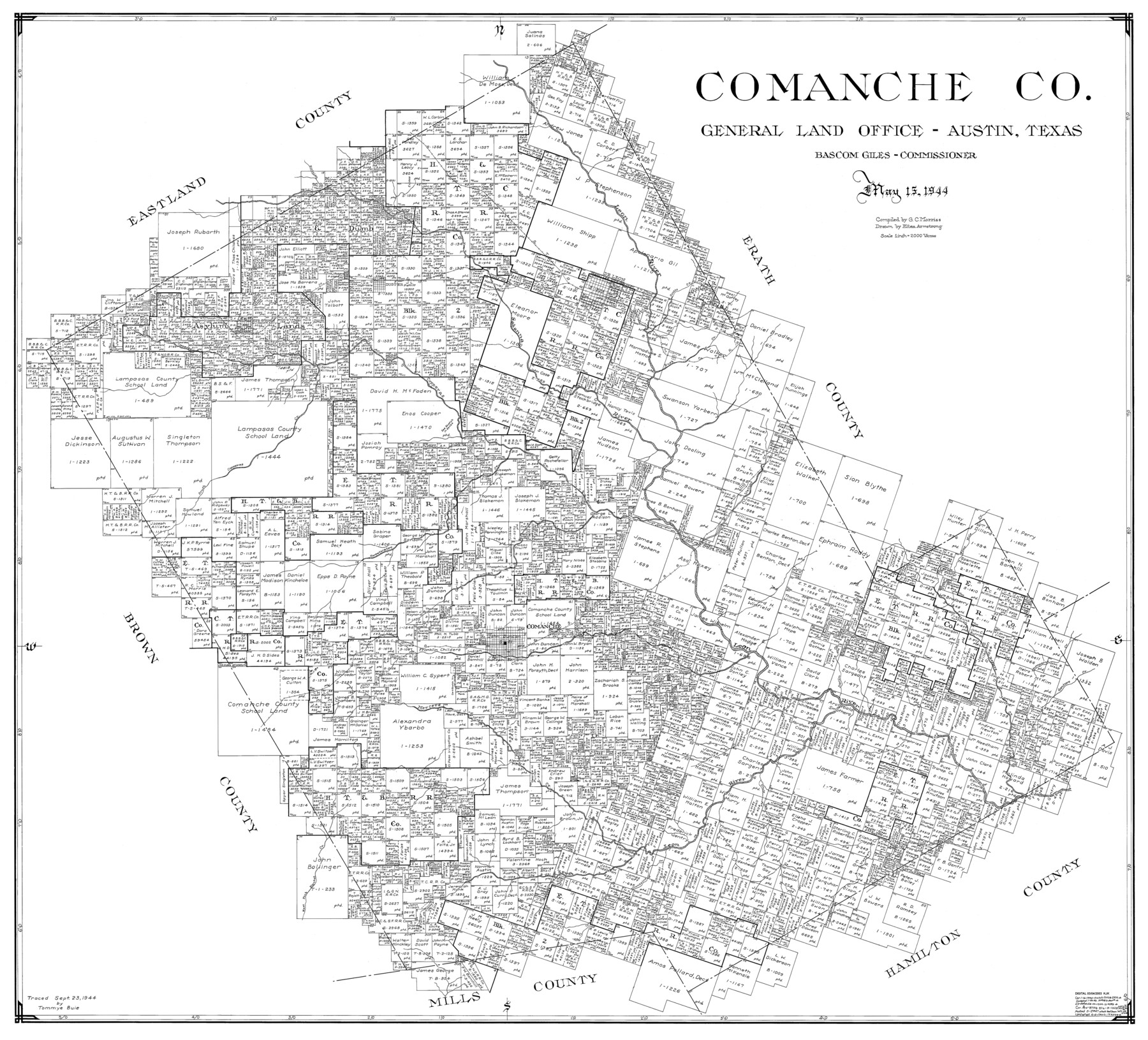
Comanche Co.
-
Map/Doc
77246
-
Collection
General Map Collection
-
Object Dates
1944/5/15 (Creation Date)
-
People and Organizations
Eltea Armstrong (Draftsman)
G.C. Morriss (Compiler)
-
Counties
Comanche
-
Subjects
County
-
Height x Width
40.4 x 44.7 inches
102.6 x 113.5 cm
Part of: General Map Collection
Nolan County Rolled Sketch 3

Print $20.00
- Digital $50.00
Nolan County Rolled Sketch 3
Size 27.9 x 26.2 inches
Map/Doc 6864
Map of Panola County Texas

Print $20.00
- Digital $50.00
Map of Panola County Texas
1850
Size 25.6 x 35.9 inches
Map/Doc 78317
Duval County Sketch File 8c

Print $4.00
- Digital $50.00
Duval County Sketch File 8c
1875
Size 10.9 x 8.6 inches
Map/Doc 21300
Matagorda County Boundary File 1a

Print $8.00
- Digital $50.00
Matagorda County Boundary File 1a
Size 14.2 x 8.6 inches
Map/Doc 56889

Cass County Sketch File 5 1/2

Print $4.00
- Digital $50.00
Cass County Sketch File 5 1/2
1851
Size 6.1 x 8.5 inches
Map/Doc 17404
Isogonic Chart for 1950, United States. Including Isoporic Lines

Print $20.00
- Digital $50.00
Isogonic Chart for 1950, United States. Including Isoporic Lines
1950
Size 32.2 x 47.2 inches
Map/Doc 75921
Gaines County Rolled Sketch 35

Print $20.00
- Digital $50.00
Gaines County Rolled Sketch 35
2014
Size 18.7 x 25.9 inches
Map/Doc 93695
Orange County Working Sketch 53

Print $20.00
- Digital $50.00
Orange County Working Sketch 53
2007
Size 34.1 x 46.0 inches
Map/Doc 87371
Current Miscellaneous File 47

Print $12.00
- Digital $50.00
Current Miscellaneous File 47
1920
Size 16.3 x 9.2 inches
Map/Doc 73992
Flight Mission No. CUI-1H, Frame 141, Milam County

Print $20.00
- Digital $50.00
Flight Mission No. CUI-1H, Frame 141, Milam County
1951
Size 18.4 x 22.3 inches
Map/Doc 86607
Aransas County Sketch File 23

Print $6.00
- Digital $50.00
Aransas County Sketch File 23
1927
Size 14.5 x 8.9 inches
Map/Doc 13174
You may also like
Mississippi River to Galveston

Print $40.00
- Digital $50.00
Mississippi River to Galveston
1966
Size 37.0 x 49.8 inches
Map/Doc 69945
Zapata County Rolled Sketch 14

Print $20.00
- Digital $50.00
Zapata County Rolled Sketch 14
1925
Size 19.2 x 43.7 inches
Map/Doc 10168
Hale County Sketch File 18

Print $4.00
- Digital $50.00
Hale County Sketch File 18
1903
Size 11.0 x 8.6 inches
Map/Doc 24749
Map of Castro County

Print $20.00
- Digital $50.00
Map of Castro County
1900
Size 43.0 x 37.3 inches
Map/Doc 4906
Collin County Working Sketch 7

Print $40.00
- Digital $50.00
Collin County Working Sketch 7
2004
Size 50.5 x 33.8 inches
Map/Doc 83563
Motley County Sketch File 24 (S)

Print $4.00
- Digital $50.00
Motley County Sketch File 24 (S)
Size 9.2 x 7.1 inches
Map/Doc 32204
Brewster County Sketch File 49

Print $26.00
- Digital $50.00
Brewster County Sketch File 49
1994
Size 14.2 x 8.8 inches
Map/Doc 16329
Calhoun County Rolled Sketch 14

Print $20.00
- Digital $50.00
Calhoun County Rolled Sketch 14
Size 21.8 x 40.2 inches
Map/Doc 5458
Atascosa County Working Sketch 5

Print $3.00
- Digital $50.00
Atascosa County Working Sketch 5
1913
Size 10.9 x 11.3 inches
Map/Doc 67201
Liberty County Working Sketch 62

Print $20.00
- Digital $50.00
Liberty County Working Sketch 62
1969
Size 22.1 x 28.3 inches
Map/Doc 70522
Morris County Rolled Sketch 2A

Print $20.00
- Digital $50.00
Morris County Rolled Sketch 2A
Size 24.0 x 18.7 inches
Map/Doc 10256
Leon County Working Sketch 26

Print $20.00
- Digital $50.00
Leon County Working Sketch 26
1969
Size 43.1 x 46.9 inches
Map/Doc 70425