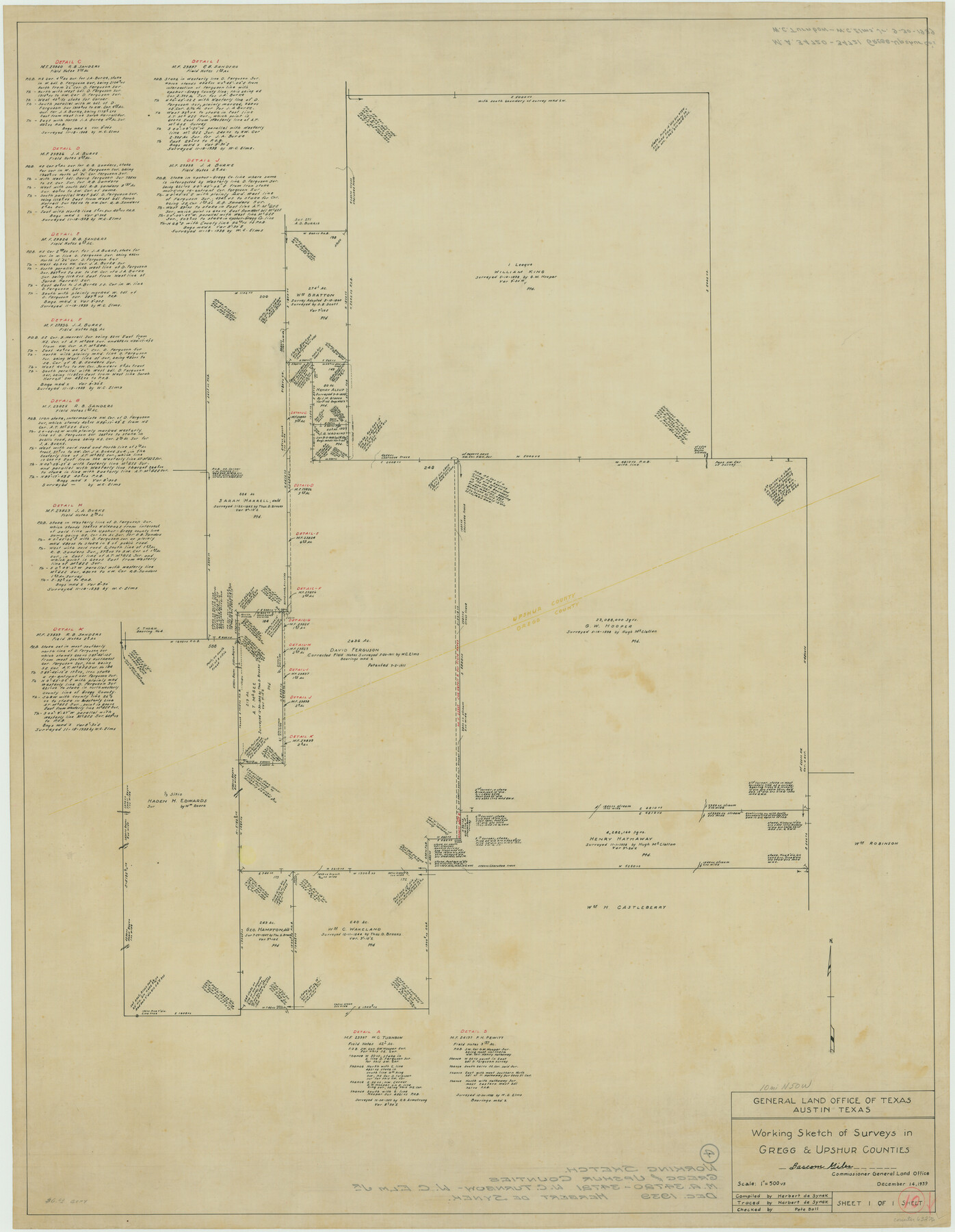
Gregg County Working Sketch 10
-
Map/Doc
63276
-
Collection
General Map Collection
-
Object Dates
12/14/1939 (Creation Date)
-
People and Organizations
Herbert de Synek (Draftsman)
-
Counties
Gregg Upshur
-
Subjects
Surveying Working Sketch
-
Height x Width
34.1 x 26.4 inches
86.6 x 67.1 cm
-
Scale
1" = 500 varas
Part of: General Map Collection
Pecos County Rolled Sketch 163

Print $20.00
- Digital $50.00
Pecos County Rolled Sketch 163
Size 28.2 x 23.9 inches
Map/Doc 7286
Traced from Genl. Arista's map captured by the American Army under Genl. Taylor at Resaca de la Palma 9th May '46 and presented to James K. Polk, President U. States

Print $20.00
- Digital $50.00
Traced from Genl. Arista's map captured by the American Army under Genl. Taylor at Resaca de la Palma 9th May '46 and presented to James K. Polk, President U. States
1846
Size 18.2 x 27.4 inches
Map/Doc 73061
Right of Way and Track Map Texas & New Orleans R.R. Co. operated by the T. & N. O. R.R. Co. Dallas-Sabine Branch

Print $40.00
- Digital $50.00
Right of Way and Track Map Texas & New Orleans R.R. Co. operated by the T. & N. O. R.R. Co. Dallas-Sabine Branch
1918
Size 24.3 x 55.9 inches
Map/Doc 64156
Houston County Rolled Sketch 5

Print $20.00
- Digital $50.00
Houston County Rolled Sketch 5
1960
Size 28.3 x 40.8 inches
Map/Doc 6227
Hudspeth County Rolled Sketch 76

Print $40.00
- Digital $50.00
Hudspeth County Rolled Sketch 76
1992
Size 49.5 x 37.7 inches
Map/Doc 9239
Flight Mission No. BRA-6M, Frame 142, Jefferson County

Print $20.00
- Digital $50.00
Flight Mission No. BRA-6M, Frame 142, Jefferson County
1953
Size 18.6 x 22.3 inches
Map/Doc 85443
Edwards County Boundary File 29

Print $22.00
- Digital $50.00
Edwards County Boundary File 29
Size 15.4 x 31.0 inches
Map/Doc 65502
Refugio County Rolled Sketch 8

Print $40.00
- Digital $50.00
Refugio County Rolled Sketch 8
1954
Size 53.9 x 46.7 inches
Map/Doc 9860
Live Oak County Boundary File 60c

Print $4.00
- Digital $50.00
Live Oak County Boundary File 60c
Size 14.0 x 8.7 inches
Map/Doc 56421
Flight Mission No. CGI-3N, Frame 74, Cameron County

Print $20.00
- Digital $50.00
Flight Mission No. CGI-3N, Frame 74, Cameron County
1954
Size 18.7 x 22.2 inches
Map/Doc 84568
Webb County Sketch File A1

Print $20.00
- Digital $50.00
Webb County Sketch File A1
1897
Size 20.3 x 20.3 inches
Map/Doc 12604

You may also like
Flight Mission No. CGN-3P, Frame 23, San Patricio County

Print $20.00
- Digital $50.00
Flight Mission No. CGN-3P, Frame 23, San Patricio County
1956
Size 18.6 x 22.2 inches
Map/Doc 86981
Duval County Rolled Sketch 25

Print $20.00
- Digital $50.00
Duval County Rolled Sketch 25
1944
Size 31.3 x 27.7 inches
Map/Doc 8813
Pecos County Rolled Sketch 115A

Print $20.00
- Digital $50.00
Pecos County Rolled Sketch 115A
1943
Size 15.8 x 15.2 inches
Map/Doc 7258
Crane County Working Sketch 30

Print $20.00
- Digital $50.00
Crane County Working Sketch 30
1980
Size 37.5 x 39.2 inches
Map/Doc 68307
Real County Working Sketch 42

Print $20.00
- Digital $50.00
Real County Working Sketch 42
1953
Size 40.3 x 34.5 inches
Map/Doc 71934
Borden County Sketch File 11

Print $4.00
- Digital $50.00
Borden County Sketch File 11
1892
Size 11.0 x 8.9 inches
Map/Doc 14730
Polk County Working Sketch 16

Print $20.00
- Digital $50.00
Polk County Working Sketch 16
1947
Size 45.7 x 27.3 inches
Map/Doc 71631
Zavala County Sketch File B

Print $34.00
- Digital $50.00
Zavala County Sketch File B
1908
Size 13.5 x 8.9 inches
Map/Doc 41364
Map of Travis County

Print $20.00
- Digital $50.00
Map of Travis County
1875
Size 20.6 x 26.4 inches
Map/Doc 4093
Map of the Pitchfork Ranch

Print $20.00
- Digital $50.00
Map of the Pitchfork Ranch
1915
Size 40.2 x 36.5 inches
Map/Doc 4490
Flight Mission No. BQR-20K, Frame 9, Brazoria County

Print $20.00
- Digital $50.00
Flight Mission No. BQR-20K, Frame 9, Brazoria County
1952
Size 18.6 x 22.4 inches
Map/Doc 84111
Midland County Rolled Sketch 4A

Print $40.00
- Digital $50.00
Midland County Rolled Sketch 4A
1951
Size 43.0 x 85.3 inches
Map/Doc 61735