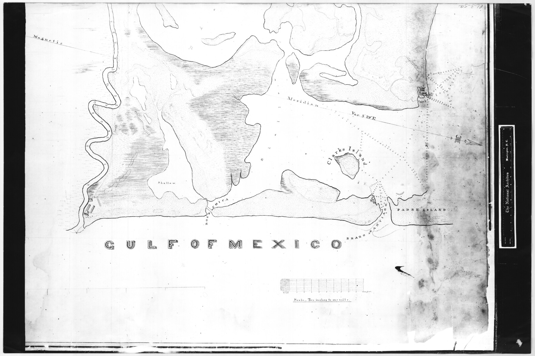
Map of the country adjacent to the left bank of the Rio Grande below Matamoros
RL-3-5a
-
Map/Doc
72870
-
Collection
General Map Collection
-
Object Dates
1847 (Creation Date)
-
People and Organizations
J.D. Webster (Surveyor/Engineer)
J.F. Mullowny (Surveyor/Engineer)
-
Height x Width
18.3 x 27.5 inches
46.5 x 69.9 cm
-
Comments
B/W photostat copy from National Archives in multiple pieces.
Part of: General Map Collection
Brazoria County Rolled Sketch 46

Print $40.00
- Digital $50.00
Brazoria County Rolled Sketch 46
1950
Size 30.7 x 57.3 inches
Map/Doc 8462
Castro County Working Sketch 2

Print $20.00
- Digital $50.00
Castro County Working Sketch 2
Size 30.4 x 26.2 inches
Map/Doc 67897

Upton County Rolled Sketch 32

Print $20.00
- Digital $50.00
Upton County Rolled Sketch 32
Size 38.6 x 39.0 inches
Map/Doc 10049
Knox County Rolled Sketch 8

Print $20.00
- Digital $50.00
Knox County Rolled Sketch 8
Size 28.2 x 32.5 inches
Map/Doc 9406
Medina County Working Sketch 5

Print $20.00
- Digital $50.00
Medina County Working Sketch 5
1949
Size 38.5 x 37.3 inches
Map/Doc 70920
Trinity County Sketch File 32

Print $20.00
- Digital $50.00
Trinity County Sketch File 32
1894
Size 22.4 x 18.3 inches
Map/Doc 12490
Randall County Sketch File 7

Print $14.00
- Digital $50.00
Randall County Sketch File 7
1931
Size 7.3 x 8.9 inches
Map/Doc 34963
Archer County Sketch File 3

Print $4.00
- Digital $50.00
Archer County Sketch File 3
Size 7.5 x 8.5 inches
Map/Doc 13628
Harrison County Sketch File 4

Print $4.00
- Digital $50.00
Harrison County Sketch File 4
Size 9.0 x 8.0 inches
Map/Doc 26040
Flight Mission No. CGI-1N, Frame 170, Cameron County

Print $20.00
- Digital $50.00
Flight Mission No. CGI-1N, Frame 170, Cameron County
1955
Size 18.5 x 22.1 inches
Map/Doc 84505
Edwards County Working Sketch 135

Print $20.00
- Digital $50.00
Edwards County Working Sketch 135
1986
Size 31.8 x 38.4 inches
Map/Doc 69011
You may also like
Gaines County Rolled Sketch 8

Print $20.00
- Digital $50.00
Gaines County Rolled Sketch 8
Size 14.6 x 20.9 inches
Map/Doc 5928
Webb County Rolled Sketch 47

Print $20.00
- Digital $50.00
Webb County Rolled Sketch 47
Size 23.5 x 31.7 inches
Map/Doc 8203
Pecos County Sketch File 27A

Print $20.00
- Digital $50.00
Pecos County Sketch File 27A
Size 26.7 x 19.8 inches
Map/Doc 12166
Brewster County Rolled Sketch 14

Print $20.00
- Digital $50.00
Brewster County Rolled Sketch 14
1889
Size 31.5 x 27.3 inches
Map/Doc 8469
Cooke County Sketch File 44

Print $20.00
- Digital $50.00
Cooke County Sketch File 44
1928
Size 20.4 x 20.6 inches
Map/Doc 11178
[Atchison, Topeka & Santa Fe from Paisano to south of Plata]
![64713, [Atchison, Topeka & Santa Fe from Paisano to south of Plata], General Map Collection](https://historictexasmaps.com/wmedia_w700/maps/64713-1.tif.jpg)
Print $40.00
- Digital $50.00
[Atchison, Topeka & Santa Fe from Paisano to south of Plata]
Size 32.2 x 116.3 inches
Map/Doc 64713
Erath County Working Sketch 47

Print $20.00
- Digital $50.00
Erath County Working Sketch 47
1984
Size 16.3 x 18.3 inches
Map/Doc 69128
La Salle County Rolled Sketch 27

Print $20.00
- Digital $50.00
La Salle County Rolled Sketch 27
1979
Size 29.0 x 38.2 inches
Map/Doc 6588
Pecos County Rolled Sketch 110

Print $20.00
- Digital $50.00
Pecos County Rolled Sketch 110
Size 29.1 x 30.4 inches
Map/Doc 7255
The Mexican Municipality of Jefferson. Defined, December 9, 1835

Print $20.00
The Mexican Municipality of Jefferson. Defined, December 9, 1835
2020
Size 15.5 x 21.7 inches
Map/Doc 96024
Eastland County Sketch File 3

Print $4.00
- Digital $50.00
Eastland County Sketch File 3
1860
Size 10.2 x 8.3 inches
Map/Doc 21566
