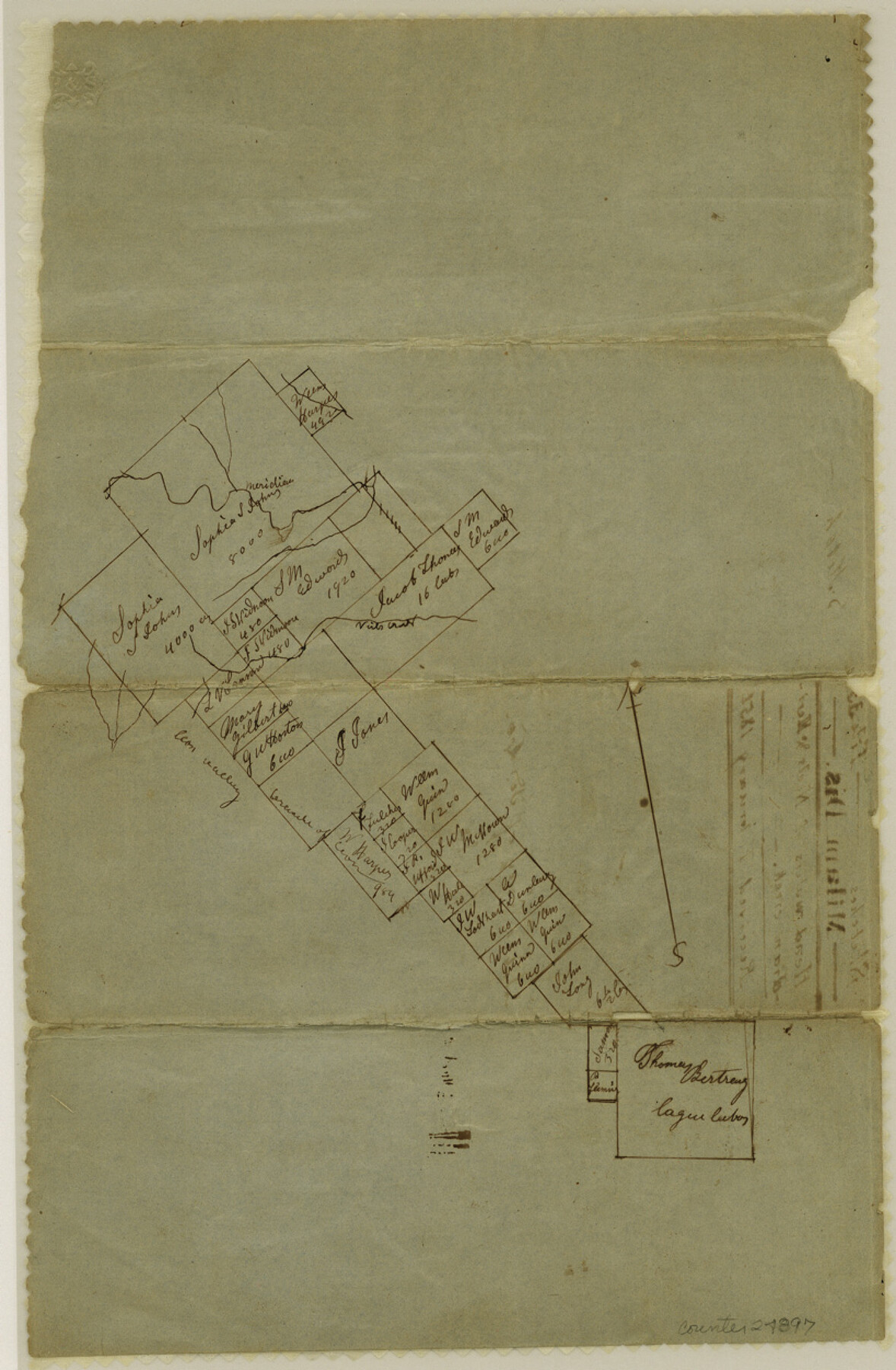
Hamilton County Sketch File 1
[Sketch on headwaters of Neels Creek and Meridian Creek]
-
Map/Doc
24897
-
Collection
General Map Collection
-
Object Dates
1851 (File Date)
-
Counties
Hamilton Bosque Coryell
-
Subjects
Surveying Sketch File
-
Height x Width
12.5 x 8.2 inches
31.8 x 20.8 cm
-
Medium
paper, manuscript
-
Features
Neels Creek
Meridian Creek
Part of: General Map Collection
Mills County Working Sketch 9

Print $20.00
- Digital $50.00
Mills County Working Sketch 9
1915
Size 13.3 x 13.7 inches
Map/Doc 71039
Coleman County Sketch File 26

Print $40.00
- Digital $50.00
Coleman County Sketch File 26
1873
Size 12.7 x 15.5 inches
Map/Doc 18712
Wise County Sketch File 26

Print $22.00
- Digital $50.00
Wise County Sketch File 26
1855
Size 8.1 x 14.3 inches
Map/Doc 40574

Mills County Sketch File 5

Print $4.00
- Digital $50.00
Mills County Sketch File 5
Size 11.5 x 8.3 inches
Map/Doc 31652
Brewster County Rolled Sketch 136

Print $20.00
- Digital $50.00
Brewster County Rolled Sketch 136
Size 21.4 x 13.2 inches
Map/Doc 5304
Montgomery County Rolled Sketch 16

Print $20.00
- Digital $50.00
Montgomery County Rolled Sketch 16
Size 28.5 x 26.6 inches
Map/Doc 6804
Maverick County Rolled Sketch 19

Print $20.00
- Digital $50.00
Maverick County Rolled Sketch 19
1955
Size 33.5 x 44.1 inches
Map/Doc 9494
Brewster County Sketch File N-3c

Print $4.00
- Digital $50.00
Brewster County Sketch File N-3c
Size 12.7 x 8.4 inches
Map/Doc 15594
Starr County Sketch File 42

Print $20.00
- Digital $50.00
Starr County Sketch File 42
1941
Size 19.0 x 21.6 inches
Map/Doc 12341
Borden County Sketch File 12

Print $24.00
- Digital $50.00
Borden County Sketch File 12
Size 10.8 x 9.1 inches
Map/Doc 14732
Flight Mission No. DAH-9M, Frame 200, Orange County

Print $20.00
- Digital $50.00
Flight Mission No. DAH-9M, Frame 200, Orange County
1953
Size 18.6 x 22.4 inches
Map/Doc 86868
You may also like
[Cotton Belt, St. Louis Southwestern Railway of Texas, Alignment through Smith County]
![64378, [Cotton Belt, St. Louis Southwestern Railway of Texas, Alignment through Smith County], General Map Collection](https://historictexasmaps.com/wmedia_w700/maps/64378.tif.jpg)
Print $20.00
- Digital $50.00
[Cotton Belt, St. Louis Southwestern Railway of Texas, Alignment through Smith County]
1903
Size 22.3 x 30.1 inches
Map/Doc 64378
Karnes County Sketch File 5

Print $7.00
- Digital $50.00
Karnes County Sketch File 5
1849
Size 8.1 x 10.0 inches
Map/Doc 28554
Dickens County Sketch File 35

Print $10.00
- Digital $50.00
Dickens County Sketch File 35
1954
Size 11.2 x 8.9 inches
Map/Doc 64791
Karnes County Sketch File 17

Print $4.00
- Digital $50.00
Karnes County Sketch File 17
1873
Size 12.8 x 8.0 inches
Map/Doc 28622
Fisher County Working Sketch 18

Print $20.00
- Digital $50.00
Fisher County Working Sketch 18
1941
Size 24.7 x 16.6 inches
Map/Doc 69152
Rand McNally Standard Map of Texas

Print $20.00
Rand McNally Standard Map of Texas
1923
Size 27.7 x 40.3 inches
Map/Doc 76259
[Beaumont, Sour Lake and Western Ry. Right of Way and Alignment - Frisco]
![64125, [Beaumont, Sour Lake and Western Ry. Right of Way and Alignment - Frisco], General Map Collection](https://historictexasmaps.com/wmedia_w700/maps/64125.tif.jpg)
Print $20.00
- Digital $50.00
[Beaumont, Sour Lake and Western Ry. Right of Way and Alignment - Frisco]
1910
Size 20.1 x 45.9 inches
Map/Doc 64125
Dimmit County Rolled Sketch 22A

Print $20.00
- Digital $50.00
Dimmit County Rolled Sketch 22A
2012
Size 23.2 x 34.0 inches
Map/Doc 93630
Topographical Map of the Rio Grande, Sheet No. 9

Print $20.00
- Digital $50.00
Topographical Map of the Rio Grande, Sheet No. 9
1912
Map/Doc 89533
Jackson County Rolled Sketch 3B

Print $20.00
- Digital $50.00
Jackson County Rolled Sketch 3B
1913
Size 23.7 x 21.8 inches
Map/Doc 6338
Karnes County Sketch File 7a

Print $4.00
- Digital $50.00
Karnes County Sketch File 7a
1873
Size 10.1 x 8.1 inches
Map/Doc 28563
Flight Mission No. DAG-21K, Frame 99, Matagorda County

Print $20.00
- Digital $50.00
Flight Mission No. DAG-21K, Frame 99, Matagorda County
1952
Size 17.5 x 16.3 inches
Map/Doc 86428