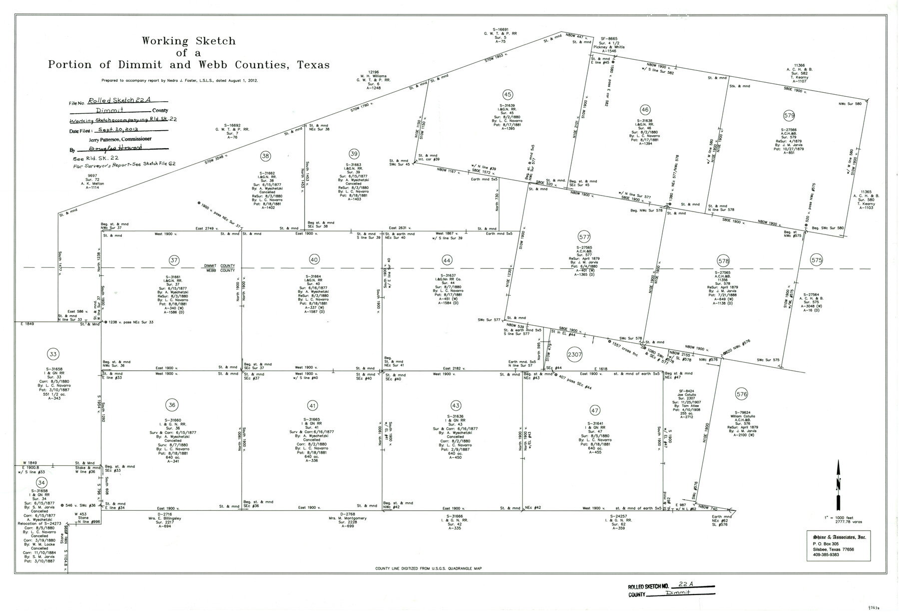
Dimmit County Rolled Sketch 22A
Working Sketch of a portion of Dimmit and Webb Counties, Texas
-
Map/Doc
93630
-
Collection
General Map Collection
-
Object Dates
2012/8/1 (Creation Date)
2013/9/10 (File Date)
-
People and Organizations
Nedra J. Foster (Surveyor/Engineer)
-
Counties
Dimmit Webb
-
Subjects
Surveying Rolled Sketch
-
Height x Width
23.2 x 34.0 inches
58.9 x 86.4 cm
-
Medium
mylar, print
-
Scale
1" = 1000 feet
-
Comments
See Dimmit County Rolled Sketch 22 (93629) for related sketch and Dimmit County Sketch File 62 (93631) for surveyor's report.
Related maps
Dimmit County Rolled Sketch 22

Print $20.00
- Digital $50.00
Dimmit County Rolled Sketch 22
2012
Size 31.5 x 24.0 inches
Map/Doc 93629
Dimmit County Sketch File 62

Print $8.00
- Digital $50.00
Dimmit County Sketch File 62
2012
Size 11.0 x 8.5 inches
Map/Doc 93631
Part of: General Map Collection
Duval County Rolled Sketch 37

Print $20.00
- Digital $50.00
Duval County Rolled Sketch 37
Size 19.8 x 16.5 inches
Map/Doc 5754
Hutchinson County Sketch File 37

Print $10.00
- Digital $50.00
Hutchinson County Sketch File 37
Size 11.3 x 8.8 inches
Map/Doc 27275
Andrews County Working Sketch 32

Print $20.00
- Digital $50.00
Andrews County Working Sketch 32
1990
Size 29.6 x 31.5 inches
Map/Doc 67078
Briscoe County Sketch File E

Print $40.00
- Digital $50.00
Briscoe County Sketch File E
Size 26.0 x 33.7 inches
Map/Doc 11003
Map of Velasco

Print $20.00
- Digital $50.00
Map of Velasco
1906
Size 32.1 x 39.4 inches
Map/Doc 95357
Hardin County Sketch File 14

Print $4.00
- Digital $50.00
Hardin County Sketch File 14
1866
Size 13.0 x 8.0 inches
Map/Doc 25120
Sketch Showing Surveys Made for W. R. Cartledge

Print $20.00
- Digital $50.00
Sketch Showing Surveys Made for W. R. Cartledge
1945
Size 17.3 x 13.8 inches
Map/Doc 60296
Upton County Rolled Sketch 3

Print $20.00
- Digital $50.00
Upton County Rolled Sketch 3
Size 30.3 x 34.1 inches
Map/Doc 8066
Young County Working Sketch 18

Print $5.00
- Digital $50.00
Young County Working Sketch 18
Size 23.9 x 29.2 inches
Map/Doc 62041
Lubbock County Boundary File 1

Print $64.00
- Digital $50.00
Lubbock County Boundary File 1
Size 8.8 x 8.6 inches
Map/Doc 56455
Flight Mission No. CRC-3R, Frame 33, Chambers County

Print $20.00
- Digital $50.00
Flight Mission No. CRC-3R, Frame 33, Chambers County
1956
Size 18.6 x 22.4 inches
Map/Doc 84806
Bandera County Working Sketch 23

Print $20.00
- Digital $50.00
Bandera County Working Sketch 23
1950
Size 35.8 x 29.6 inches
Map/Doc 67619
You may also like
Cass County Sketch File 7

Print $4.00
- Digital $50.00
Cass County Sketch File 7
1853
Size 8.0 x 12.6 inches
Map/Doc 17408
Montgomery County Rolled Sketch 12

Print $20.00
- Digital $50.00
Montgomery County Rolled Sketch 12
Size 23.4 x 30.5 inches
Map/Doc 6801
Flight Mission No. DQN-1K, Frame 152, Calhoun County

Print $20.00
- Digital $50.00
Flight Mission No. DQN-1K, Frame 152, Calhoun County
1953
Size 18.6 x 22.3 inches
Map/Doc 84211
Reeves County Sketch File 18

Print $40.00
- Digital $50.00
Reeves County Sketch File 18
1926
Size 22.2 x 9.4 inches
Map/Doc 35210
Brewster County Rolled Sketch 26

Print $20.00
- Digital $50.00
Brewster County Rolled Sketch 26
Size 15.8 x 32.0 inches
Map/Doc 5214
Travis County Appraisal District Plat Map 2_0905

Print $20.00
- Digital $50.00
Travis County Appraisal District Plat Map 2_0905
Size 21.4 x 26.4 inches
Map/Doc 94232
Terrell County Working Sketch 74

Print $20.00
- Digital $50.00
Terrell County Working Sketch 74
Size 37.5 x 24.6 inches
Map/Doc 69595
United States - Gulf Coast - Galveston to Rio Grande

Print $20.00
- Digital $50.00
United States - Gulf Coast - Galveston to Rio Grande
1940
Size 27.0 x 18.2 inches
Map/Doc 72755
Mills County Boundary File 11

Print $20.00
- Digital $50.00
Mills County Boundary File 11
Size 17.2 x 22.1 inches
Map/Doc 57333
Hidalgo County Sketch File 14

Print $20.00
- Digital $50.00
Hidalgo County Sketch File 14
Size 29.6 x 24.5 inches
Map/Doc 11764
Cottle County Working Sketch 20

Print $20.00
- Digital $50.00
Cottle County Working Sketch 20
1982
Size 19.9 x 37.0 inches
Map/Doc 68330
Live Oak County Rolled Sketch 4

Print $20.00
- Digital $50.00
Live Oak County Rolled Sketch 4
1946
Size 27.7 x 32.1 inches
Map/Doc 6633