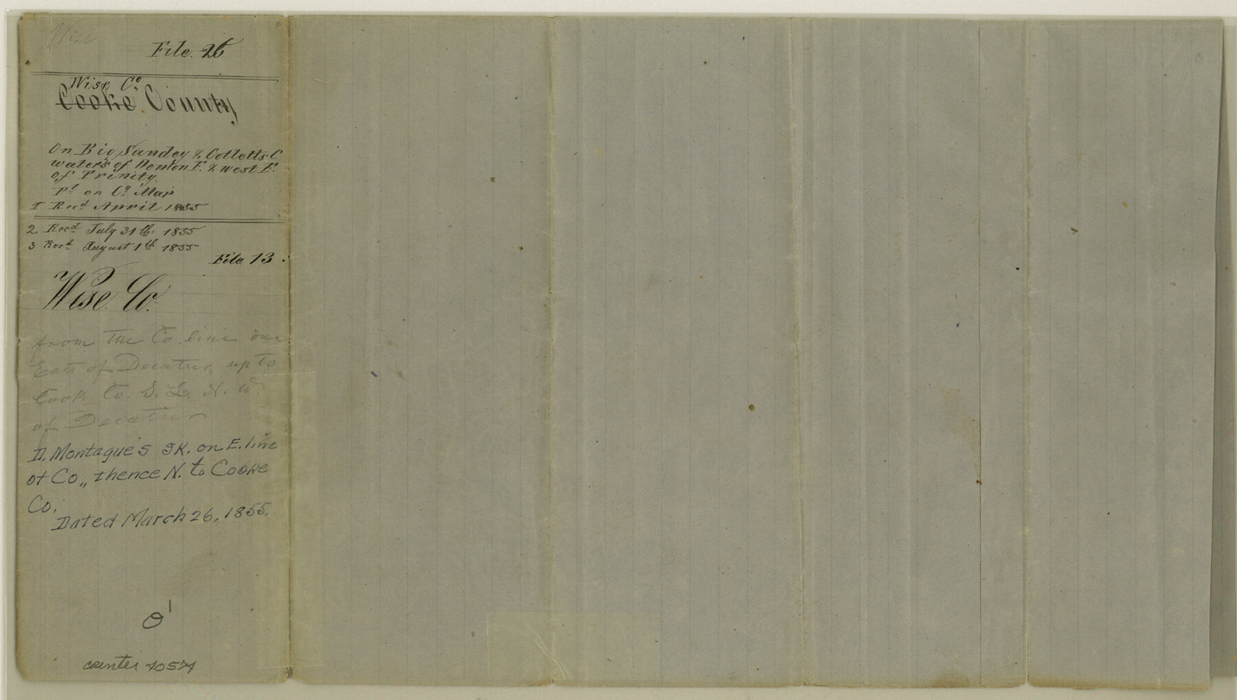
Wise County Sketch File 26
[Sketch of surveys east and northwest from Decatur]
-
Map/Doc
40574
-
Collection
General Map Collection
-
Object Dates
3/26/1855 (Creation Date)
-
People and Organizations
Daniel Montague (Surveyor/Engineer)
-
Counties
Wise Montague
-
Subjects
Surveying Sketch File
-
Height x Width
8.1 x 14.3 inches
20.6 x 36.3 cm
-
Medium
paper, manuscript
-
Features
Big Sandy Creek
Cotlett's Creek
Denton Fork of Trinity River
West Fork of Trinity River
Denton Creek
Part of: General Map Collection
Pecos County Sketch File 111

Print $18.00
- Digital $50.00
Pecos County Sketch File 111
Size 13.3 x 8.8 inches
Map/Doc 34052
Ward County Working Sketch 1

Print $20.00
- Digital $50.00
Ward County Working Sketch 1
1937
Size 24.7 x 24.5 inches
Map/Doc 72307
Hardeman County Sketch File Y

Print $4.00
- Digital $50.00
Hardeman County Sketch File Y
Size 9.2 x 8.5 inches
Map/Doc 25054
[Surveys in the Bexar District along the Leona River]
![135, [Surveys in the Bexar District along the Leona River], General Map Collection](https://historictexasmaps.com/wmedia_w700/maps/135.tif.jpg)
Print $20.00
- Digital $50.00
[Surveys in the Bexar District along the Leona River]
1841
Size 19.9 x 10.9 inches
Map/Doc 135
Van Zandt County Sketch File 18

Print $4.00
- Digital $50.00
Van Zandt County Sketch File 18
1858
Size 9.7 x 7.7 inches
Map/Doc 39420
La Salle County Sketch File 30

Print $22.00
- Digital $50.00
La Salle County Sketch File 30
1880
Size 12.6 x 8.2 inches
Map/Doc 29565
Flight Mission No. BRE-2P, Frame 77, Nueces County

Print $20.00
- Digital $50.00
Flight Mission No. BRE-2P, Frame 77, Nueces County
1956
Size 18.4 x 22.2 inches
Map/Doc 86772
Clay County Boundary File 10

Print $6.00
- Digital $50.00
Clay County Boundary File 10
Size 14.2 x 8.8 inches
Map/Doc 51397
Morris County Rolled Sketch 2A

Print $20.00
- Digital $50.00
Morris County Rolled Sketch 2A
Size 36.2 x 19.3 inches
Map/Doc 10282
Map of Shackelford County

Print $20.00
- Digital $50.00
Map of Shackelford County
1878
Size 25.0 x 20.2 inches
Map/Doc 4025
Blanco County Sketch File 22

Print $4.00
- Digital $50.00
Blanco County Sketch File 22
1884
Size 8.7 x 15.5 inches
Map/Doc 14604
Fannin County Sketch File 15

Print $6.00
- Digital $50.00
Fannin County Sketch File 15
1866
Size 8.2 x 8.2 inches
Map/Doc 22466
You may also like


Parker County Sketch File C

Print $4.00
- Digital $50.00
Parker County Sketch File C
1857
Size 6.1 x 7.8 inches
Map/Doc 33512
Edwards County Working Sketch 101

Print $20.00
- Digital $50.00
Edwards County Working Sketch 101
1971
Size 36.9 x 38.8 inches
Map/Doc 68977
[Nueces Bay, Mustang Island and Padre Island]
![73463, [Nueces Bay, Mustang Island and Padre Island], General Map Collection](https://historictexasmaps.com/wmedia_w700/maps/73463-1.tif.jpg)
Print $4.00
- Digital $50.00
[Nueces Bay, Mustang Island and Padre Island]
1887
Size 18.5 x 26.2 inches
Map/Doc 73463
Duval County Working Sketch 6

Print $20.00
- Digital $50.00
Duval County Working Sketch 6
1935
Size 26.9 x 21.8 inches
Map/Doc 68719
Right of Way and Track Map, Texas & New Orleans R.R. Co. operated by the T. & N. O. R.R. Co., Dallas-Sabine Branch

Print $40.00
- Digital $50.00
Right of Way and Track Map, Texas & New Orleans R.R. Co. operated by the T. & N. O. R.R. Co., Dallas-Sabine Branch
1918
Size 24.9 x 56.9 inches
Map/Doc 64630
Map of the CB Live Stock Co. -N- Ranch situated in Crosby County, Texas

Print $20.00
- Digital $50.00
Map of the CB Live Stock Co. -N- Ranch situated in Crosby County, Texas
1907
Size 41.4 x 38.0 inches
Map/Doc 89919
County Map of Texas and Indian Territory

Print $20.00
- Digital $50.00
County Map of Texas and Indian Territory
1881
Size 13.1 x 9.9 inches
Map/Doc 94153
Dawson County Rolled Sketch 11

Print $20.00
- Digital $50.00
Dawson County Rolled Sketch 11
1961
Size 21.5 x 26.1 inches
Map/Doc 5694
Shelby County Rolled Sketch 16

Print $20.00
- Digital $50.00
Shelby County Rolled Sketch 16
1935
Size 33.0 x 43.8 inches
Map/Doc 9925
Presidio County Working Sketch 34

Print $20.00
- Digital $50.00
Presidio County Working Sketch 34
1947
Size 41.7 x 37.6 inches
Map/Doc 71711