Karnes County Sketch File 17
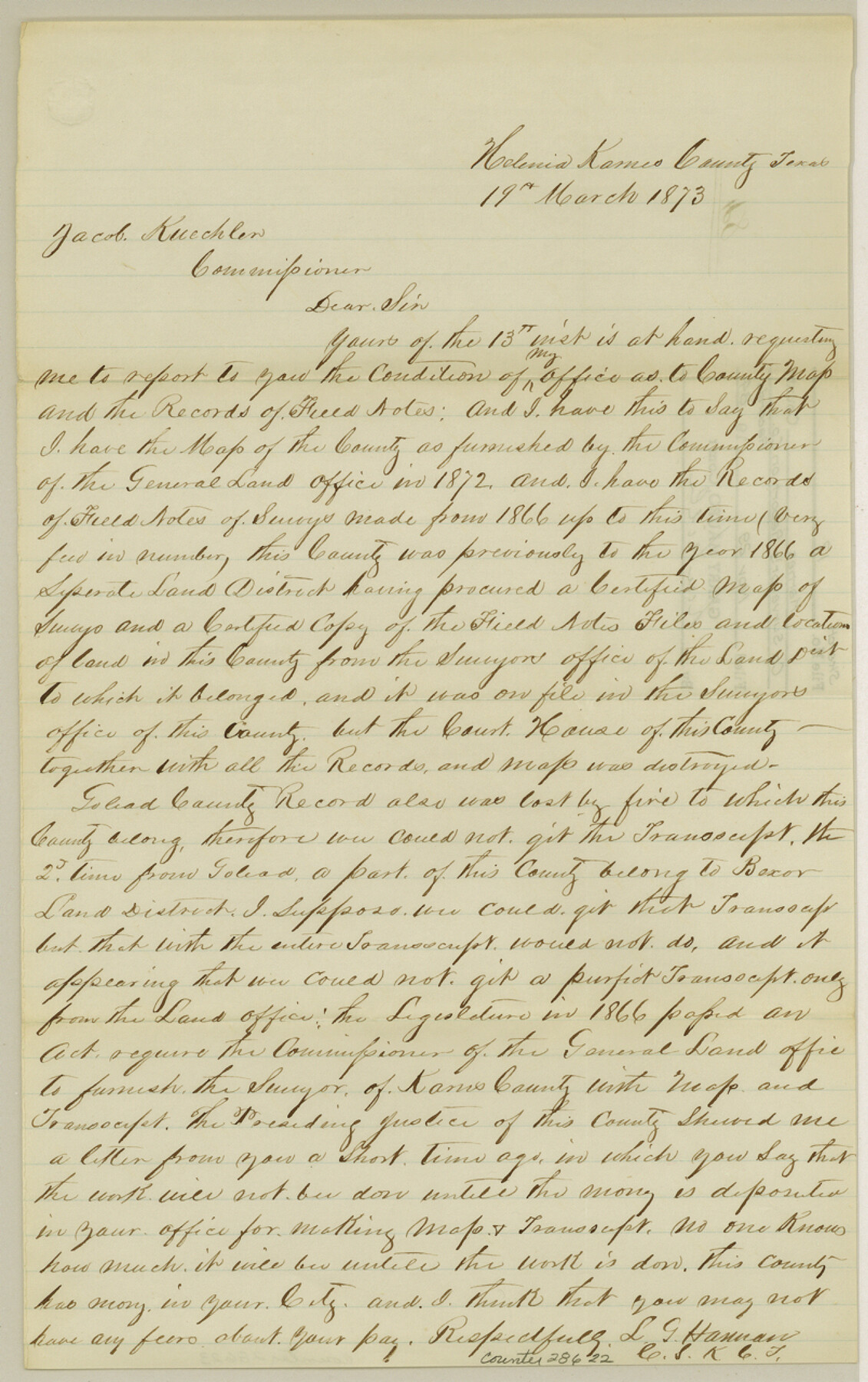
[County Surveyor's report on county records]
-
Map/Doc
28622
-
Collection
General Map Collection
-
Object Dates
3/19/1873 (Creation Date)
11/29/1984 (File Date)
1866 (Survey Date)
-
People and Organizations
L.G. Hannan (Surveyor/Engineer)
-
Counties
Karnes
-
Subjects
Surveying Sketch File
-
Height x Width
12.8 x 8.0 inches
32.5 x 20.3 cm
-
Medium
paper, manuscript
Part of: General Map Collection
San Patricio County Sketch File 38

Print $112.00
- Digital $50.00
San Patricio County Sketch File 38
Size 7.9 x 7.3 inches
Map/Doc 36176
Jefferson County Rolled Sketch 48A

Print $20.00
- Digital $50.00
Jefferson County Rolled Sketch 48A
1964
Size 28.4 x 28.1 inches
Map/Doc 6404
Trinity County Sketch File 14

Print $4.00
- Digital $50.00
Trinity County Sketch File 14
1862
Size 8.7 x 12.0 inches
Map/Doc 38540
Medina County Working Sketch 30

Print $20.00
- Digital $50.00
Medina County Working Sketch 30
1992
Size 19.2 x 15.4 inches
Map/Doc 70945
Angelina County Working Sketch 17

Print $20.00
- Digital $50.00
Angelina County Working Sketch 17
1942
Size 18.6 x 13.8 inches
Map/Doc 67098
Greater Austin, Texas Streetmap

Greater Austin, Texas Streetmap
Size 46.1 x 36.3 inches
Map/Doc 94430
Map of Retrieve Plantation, Brazoria County, Texas

Print $20.00
- Digital $50.00
Map of Retrieve Plantation, Brazoria County, Texas
Size 26.6 x 28.5 inches
Map/Doc 62999
South Sulphur River, Bonner Point Sheet

Print $20.00
- Digital $50.00
South Sulphur River, Bonner Point Sheet
1922
Size 32.9 x 35.7 inches
Map/Doc 65164
Galveston County Rolled Sketch 44

Print $2.00
- Digital $50.00
Galveston County Rolled Sketch 44
Size 17.6 x 11.3 inches
Map/Doc 5976
Flight Mission No. BRA-9M, Frame 61, Jefferson County

Print $20.00
- Digital $50.00
Flight Mission No. BRA-9M, Frame 61, Jefferson County
1953
Size 18.7 x 22.4 inches
Map/Doc 85644
Sketch of a portion of the Texas Coast showing the relative positions of different harbours with the interior Military Posts, and the roads communicating with them, also two new routes from Black Point and Lamar to San Antonio

Print $20.00
- Digital $50.00
Sketch of a portion of the Texas Coast showing the relative positions of different harbours with the interior Military Posts, and the roads communicating with them, also two new routes from Black Point and Lamar to San Antonio
1855
Size 27.3 x 18.3 inches
Map/Doc 72710
Tarrant County Working Sketch 7

Print $40.00
- Digital $50.00
Tarrant County Working Sketch 7
1981
Size 18.9 x 54.3 inches
Map/Doc 62424
You may also like
Henderson County Boundary File 3c

Print $40.00
- Digital $50.00
Henderson County Boundary File 3c
Size 22.5 x 80.6 inches
Map/Doc 54707
Haskell County Working Sketch 17

Print $20.00
- Digital $50.00
Haskell County Working Sketch 17
2011
Size 34.3 x 32.3 inches
Map/Doc 89989
Outer Continental Shelf Leasing Maps (Louisiana Offshore Operations)

Print $20.00
- Digital $50.00
Outer Continental Shelf Leasing Maps (Louisiana Offshore Operations)
1959
Size 17.8 x 14.0 inches
Map/Doc 76106
[Sketch showing position of 287.2 acres of land surveyed for W. D. Twichell]
![91904, [Sketch showing position of 287.2 acres of land surveyed for W. D. Twichell], Twichell Survey Records](https://historictexasmaps.com/wmedia_w700/maps/91904-2.tif.jpg)
Print $2.00
- Digital $50.00
[Sketch showing position of 287.2 acres of land surveyed for W. D. Twichell]
1919
Size 15.2 x 7.3 inches
Map/Doc 91904
Jackson County Sketch File 4

Print $20.00
- Digital $50.00
Jackson County Sketch File 4
Size 18.2 x 22.7 inches
Map/Doc 11834
Map of Limestone County

Print $20.00
- Digital $50.00
Map of Limestone County
1877
Size 24.1 x 26.9 inches
Map/Doc 83012
[Sketch showing parts of H. & G. N. RR. Co. Blocks 7 and 8, K. Aycock Block 4, G. H. & H. RR. Co. Block 5 and various surveys west]
![90871, [Sketch showing parts of H. & G. N. RR. Co. Blocks 7 and 8, K. Aycock Block 4, G. H. & H. RR. Co. Block 5 and various surveys west], Twichell Survey Records](https://historictexasmaps.com/wmedia_w700/maps/90871-2.tif.jpg)
Print $20.00
- Digital $50.00
[Sketch showing parts of H. & G. N. RR. Co. Blocks 7 and 8, K. Aycock Block 4, G. H. & H. RR. Co. Block 5 and various surveys west]
1902
Size 25.5 x 17.3 inches
Map/Doc 90871
Texas State Boundary Line 3

Print $90.00
- Digital $50.00
Texas State Boundary Line 3
Size 10.9 x 8.2 inches
Map/Doc 74904
Jasper County Texas

Print $20.00
- Digital $50.00
Jasper County Texas
1879
Size 31.5 x 18.2 inches
Map/Doc 3716
Comanche County

Print $20.00
- Digital $50.00
Comanche County
1896
Size 40.5 x 45.1 inches
Map/Doc 66783
Erath County Working Sketch 50a

Print $20.00
- Digital $50.00
Erath County Working Sketch 50a
Size 43.2 x 37.0 inches
Map/Doc 69131
