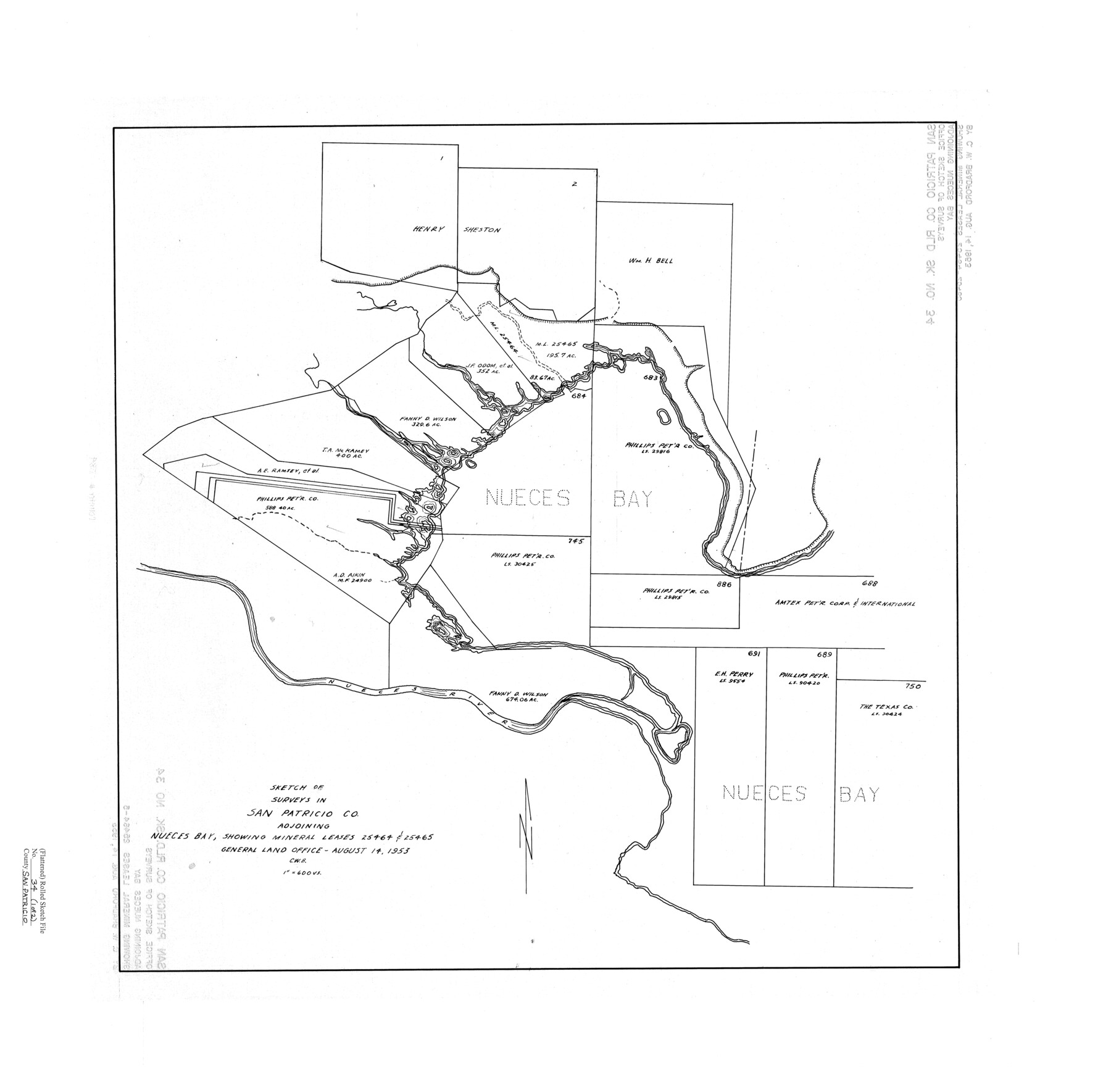
San Patricio County Rolled Sketch 34
Sketch of surveys in San Patricio Co. adjoining Nueces Bay, showing mineral leases 25464 & 25465
-
Map/Doc
7584
-
Collection
General Map Collection
-
Counties
San Patricio
-
Subjects
Surveying Rolled Sketch
-
Height x Width
25.8 x 26.2 inches
65.5 x 66.5 cm
-
Scale
1" = 600 varas
Part of: General Map Collection
Ward County Working Sketch 39

Print $20.00
- Digital $50.00
Ward County Working Sketch 39
1969
Size 24.2 x 45.5 inches
Map/Doc 72345
Flight Mission No. DCL-4C, Frame 146, Kenedy County

Print $20.00
- Digital $50.00
Flight Mission No. DCL-4C, Frame 146, Kenedy County
1943
Size 18.6 x 22.3 inches
Map/Doc 85824
Flight Mission No. BRA-16M, Frame 160, Jefferson County

Print $20.00
- Digital $50.00
Flight Mission No. BRA-16M, Frame 160, Jefferson County
1953
Size 18.7 x 22.3 inches
Map/Doc 85758
Sabine County Sketch File 6b

Print $4.00
Sabine County Sketch File 6b
1879
Size 8.1 x 9.0 inches
Map/Doc 35617
A Map of Gonzales County

Print $20.00
- Digital $50.00
A Map of Gonzales County
1838
Size 34.7 x 39.2 inches
Map/Doc 16838
Wilbarger County Sketch File 29

Print $18.00
- Digital $50.00
Wilbarger County Sketch File 29
2016
Size 11.0 x 8.5 inches
Map/Doc 95325
Oldham County Sketch File 15

Print $6.00
- Digital $50.00
Oldham County Sketch File 15
1904
Size 11.2 x 8.5 inches
Map/Doc 33261
Kimble County Sketch File 9a

Print $4.00
- Digital $50.00
Kimble County Sketch File 9a
Size 12.4 x 9.2 inches
Map/Doc 28929
Lynn County Working Sketch 4

Print $20.00
- Digital $50.00
Lynn County Working Sketch 4
1965
Size 33.5 x 33.8 inches
Map/Doc 70674
Denton County Sketch File 37

Print $24.00
- Digital $50.00
Denton County Sketch File 37
1932
Size 11.5 x 8.9 inches
Map/Doc 20776
Map of Texas compiled from surveys recorded in the Land Office of Texas and other official surveys

Print $20.00
- Digital $50.00
Map of Texas compiled from surveys recorded in the Land Office of Texas and other official surveys
1841
Size 24.6 x 24.2 inches
Map/Doc 96435
Zavalla County

Print $20.00
- Digital $50.00
Zavalla County
1879
Size 22.8 x 27.2 inches
Map/Doc 4182
You may also like
Map of Eastland County

Print $20.00
- Digital $50.00
Map of Eastland County
1877
Size 26.5 x 24.6 inches
Map/Doc 4535
[Sketch showing C. D. & W. A. Murphy's Pasture and Wint Barfield's Pasture]
![90935, [Sketch showing C. D. & W. A. Murphy's Pasture and Wint Barfield's Pasture], Twichell Survey Records](https://historictexasmaps.com/wmedia_w700/maps/90935-1.tif.jpg)
Print $20.00
- Digital $50.00
[Sketch showing C. D. & W. A. Murphy's Pasture and Wint Barfield's Pasture]
Size 30.4 x 26.7 inches
Map/Doc 90935
Hardin County Working Sketch 37

Print $40.00
- Digital $50.00
Hardin County Working Sketch 37
1981
Size 68.5 x 37.4 inches
Map/Doc 63435
Bosque County Working Sketch 4

Print $20.00
- Digital $50.00
Bosque County Working Sketch 4
1901
Size 14.2 x 18.6 inches
Map/Doc 67437
[T. & P. Surveys in Crane, Upton, Coke Counties]
![90464, [T. & P. Surveys in Crane, Upton, Coke Counties], Twichell Survey Records](https://historictexasmaps.com/wmedia_w700/maps/90464-1.tif.jpg)
Print $20.00
- Digital $50.00
[T. & P. Surveys in Crane, Upton, Coke Counties]
Size 19.2 x 21.2 inches
Map/Doc 90464

Mills County Boundary File Index

Print $2.00
- Digital $50.00
Mills County Boundary File Index
Size 8.8 x 8.9 inches
Map/Doc 57258
Glasscock County Working Sketch 8

Print $20.00
- Digital $50.00
Glasscock County Working Sketch 8
Size 42.7 x 10.3 inches
Map/Doc 62189
Travis County Appraisal District Plat Map 2_0803

Print $20.00
- Digital $50.00
Travis County Appraisal District Plat Map 2_0803
Size 21.5 x 26.4 inches
Map/Doc 94239
Ector County Sketch File 2

Print $3.00
- Digital $50.00
Ector County Sketch File 2
1933
Size 19.4 x 16.1 inches
Map/Doc 11416
Trinity County Sketch File 1

Print $4.00
- Digital $50.00
Trinity County Sketch File 1
1855
Size 8.3 x 8.2 inches
Map/Doc 38488
Ramon de la Garza 11 Leagues Houston and Robertson Districts

Print $2.00
- Digital $50.00
Ramon de la Garza 11 Leagues Houston and Robertson Districts
Size 11.5 x 8.5 inches
Map/Doc 181