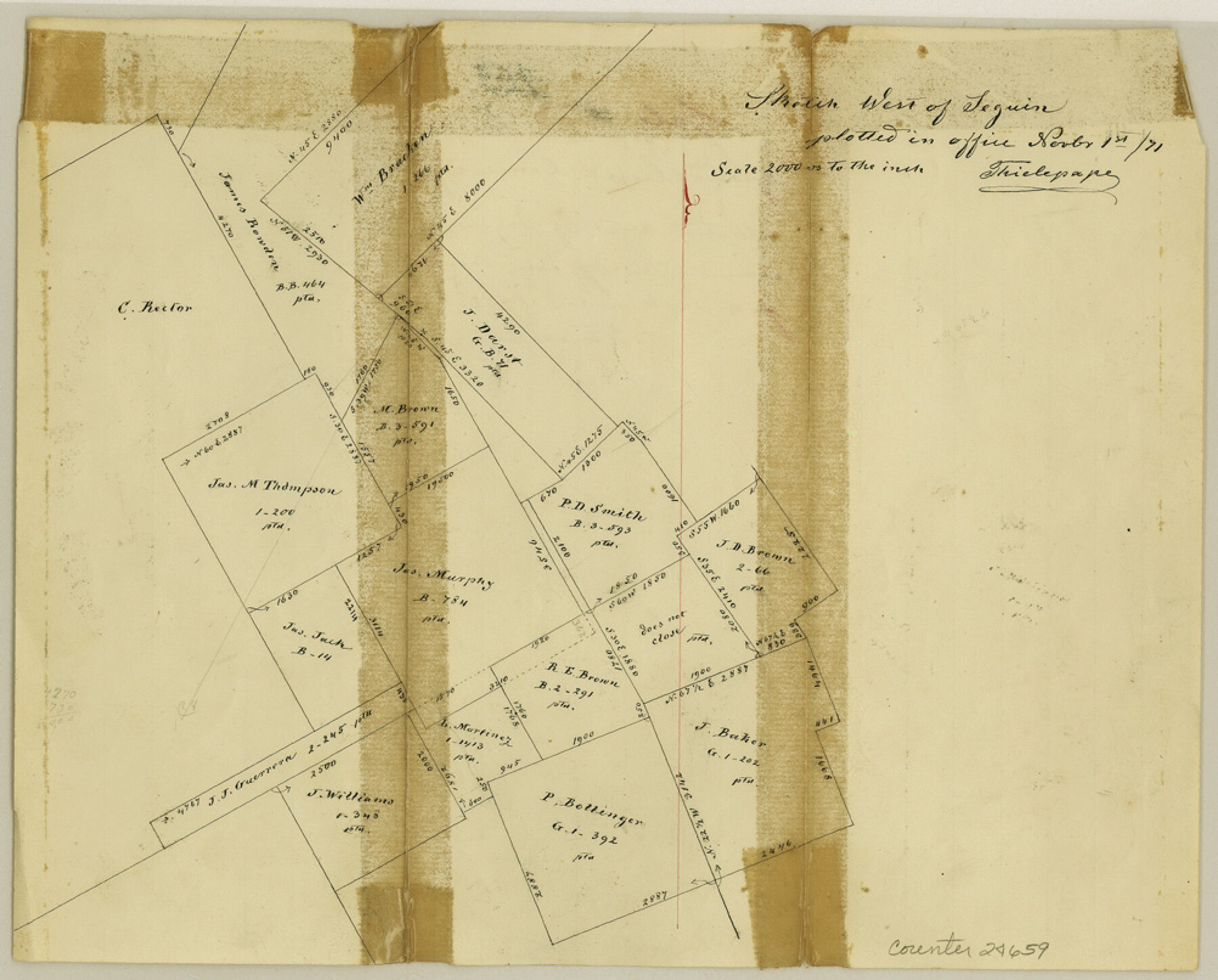
Guadalupe County Sketch File 5
[Sketch west of Seguin]
-
Map/Doc
24659
-
Collection
General Map Collection
-
Object Dates
1871/11/2 (Creation Date)
1871/11/2 (File Date)
-
People and Organizations
Thielepape (Draftsman)
-
Counties
Guadalupe
-
Subjects
Surveying Sketch File
-
Height x Width
8.1 x 10.0 inches
20.6 x 25.4 cm
-
Medium
paper, manuscript
-
Scale
1:2000
Part of: General Map Collection
[Surveys along Rabb's Creek]
![154, [Surveys along Rabb's Creek], General Map Collection](https://historictexasmaps.com/wmedia_w700/maps/154.tif.jpg)
Print $2.00
- Digital $50.00
[Surveys along Rabb's Creek]
1841
Size 8.7 x 11.0 inches
Map/Doc 154
Polk County Rolled Sketch FD

Print $40.00
- Digital $50.00
Polk County Rolled Sketch FD
Size 99.8 x 38.2 inches
Map/Doc 9754
Capitol Complex, Austin, Texas

Print $20.00
- Digital $50.00
Capitol Complex, Austin, Texas
1974
Size 42.7 x 30.6 inches
Map/Doc 94241
DeWitt County Working Sketch 12

Print $20.00
- Digital $50.00
DeWitt County Working Sketch 12
1981
Size 17.0 x 12.5 inches
Map/Doc 68602
Madison County Working Sketch 15

Print $20.00
- Digital $50.00
Madison County Working Sketch 15
2009
Size 42.3 x 36.0 inches
Map/Doc 89019
Washington County

Print $20.00
- Digital $50.00
Washington County
1863
Size 15.9 x 27.2 inches
Map/Doc 4127
Upshur County Sketch File 16

Print $20.00
- Digital $50.00
Upshur County Sketch File 16
1873
Size 19.1 x 28.0 inches
Map/Doc 12506
Kendall County Sketch File 29

Print $14.00
- Digital $50.00
Kendall County Sketch File 29
1990
Size 14.0 x 8.5 inches
Map/Doc 95291
Township No. 5 South Range No. 16 West of the Indian Meridian

Print $4.00
- Digital $50.00
Township No. 5 South Range No. 16 West of the Indian Meridian
1875
Size 17.8 x 22.6 inches
Map/Doc 75163
Val Verde Co.

Print $20.00
- Digital $50.00
Val Verde Co.
1908
Size 40.9 x 38.5 inches
Map/Doc 63101
Blanco County Sketch File 24

Print $4.00
- Digital $50.00
Blanco County Sketch File 24
Size 8.9 x 14.4 inches
Map/Doc 14614
Flight Mission No. CRE-3R, Frame 39, Jackson County

Print $20.00
- Digital $50.00
Flight Mission No. CRE-3R, Frame 39, Jackson County
1956
Size 18.6 x 22.2 inches
Map/Doc 85386
You may also like
Collin County Sketch File 1

Print $6.00
- Digital $50.00
Collin County Sketch File 1
1853
Size 6.4 x 8.2 inches
Map/Doc 18855
[Blocks 2, 3, 4, 7, and B2]
![90754, [Blocks 2, 3, 4, 7, and B2], Twichell Survey Records](https://historictexasmaps.com/wmedia_w700/maps/90754-1.tif.jpg)
Print $20.00
- Digital $50.00
[Blocks 2, 3, 4, 7, and B2]
1882
Size 20.0 x 25.6 inches
Map/Doc 90754
Sherman County Boundary File 1

Print $20.00
- Digital $50.00
Sherman County Boundary File 1
Size 11.4 x 8.9 inches
Map/Doc 58751
Current Miscellaneous File 74

Print $14.00
- Digital $50.00
Current Miscellaneous File 74
1850
Size 11.2 x 8.7 inches
Map/Doc 74181
Hamilton County Working Sketch Graphic Index

Print $20.00
- Digital $50.00
Hamilton County Working Sketch Graphic Index
1972
Size 34.3 x 39.8 inches
Map/Doc 76564
Refugio County Working Sketch 2

Print $20.00
- Digital $50.00
Refugio County Working Sketch 2
Size 17.6 x 19.4 inches
Map/Doc 63511

Montgomery County Sketch File 20

Print $38.00
- Digital $50.00
Montgomery County Sketch File 20
1932
Size 14.3 x 8.8 inches
Map/Doc 31847
Hutchinson County Working Sketch 41

Print $4.00
- Digital $50.00
Hutchinson County Working Sketch 41
1978
Size 26.8 x 22.3 inches
Map/Doc 66401
Shackelford County Boundary File 5

Print $14.00
- Digital $50.00
Shackelford County Boundary File 5
Size 8.6 x 14.0 inches
Map/Doc 58661
Fisher County Working Sketch 15

Print $20.00
- Digital $50.00
Fisher County Working Sketch 15
1958
Size 22.2 x 22.6 inches
Map/Doc 69149
