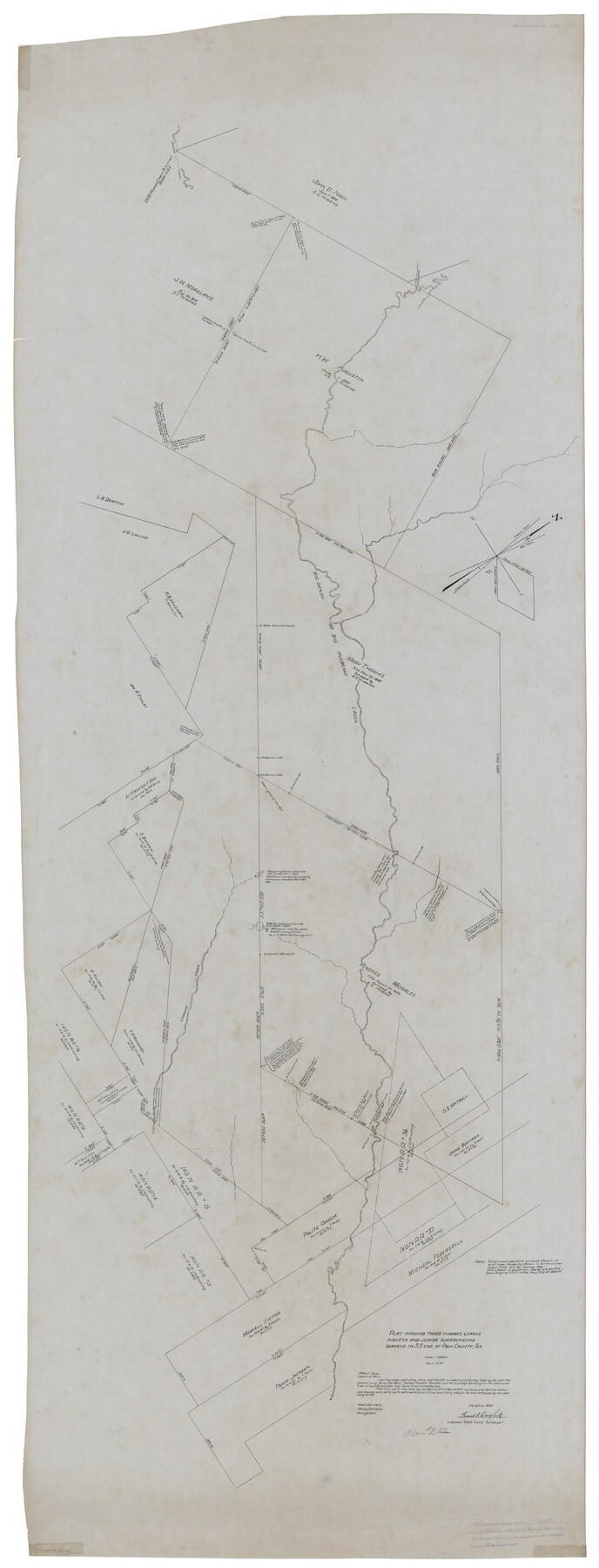
Polk County Rolled Sketch FD
Plat showing three Hirams' league surveys and junior surronding surveys in SE cor. of Polk County, Tex.
-
Map/Doc
9754
-
Collection
General Map Collection
-
People and Organizations
Frank O. Daugherty (Surveyor/Engineer)
Henry Williams (Chainman/Field Personnel)
George Cain (Chainman/Field Personnel)
-
Counties
Polk
-
Subjects
Surveying Rolled Sketch
-
Height x Width
99.8 x 38.2 inches
253.5 x 97.0 cm
-
Medium
linen, manuscript
-
Scale
1" = 300 varas
Part of: General Map Collection
Presidio County Working Sketch 86

Print $20.00
- Digital $50.00
Presidio County Working Sketch 86
1971
Size 45.4 x 42.2 inches
Map/Doc 71763
Webb County Rolled Sketch 69

Print $20.00
- Digital $50.00
Webb County Rolled Sketch 69
1964
Size 13.9 x 22.3 inches
Map/Doc 8216
Flight Mission No. BQR-13K, Frame 161, Brazoria County

Print $20.00
- Digital $50.00
Flight Mission No. BQR-13K, Frame 161, Brazoria County
1952
Size 18.7 x 22.3 inches
Map/Doc 84086
Coast of Texas from head of East Bay Galveston Harbor to Sabine Pass

Print $40.00
- Digital $50.00
Coast of Texas from head of East Bay Galveston Harbor to Sabine Pass
1882
Size 32.6 x 54.1 inches
Map/Doc 69838
Burleson County Working Sketch 37

Print $20.00
- Digital $50.00
Burleson County Working Sketch 37
1982
Size 33.7 x 44.3 inches
Map/Doc 67756
Baylor County Sketch File 27

Print $4.00
- Digital $50.00
Baylor County Sketch File 27
1895
Size 11.1 x 8.9 inches
Map/Doc 14226
Schleicher County Sketch File 33

Print $8.00
- Digital $50.00
Schleicher County Sketch File 33
1948
Size 11.3 x 8.9 inches
Map/Doc 36534
[Maps of surveys in Reeves & Culberson Cos]
![61145, [Maps of surveys in Reeves & Culberson Cos], General Map Collection](https://historictexasmaps.com/wmedia_w700/maps/61145.tif.jpg)
Print $20.00
- Digital $50.00
[Maps of surveys in Reeves & Culberson Cos]
1937
Size 30.8 x 25.0 inches
Map/Doc 61145
Flight Mission No. DQN-1K, Frame 80, Calhoun County

Print $20.00
- Digital $50.00
Flight Mission No. DQN-1K, Frame 80, Calhoun County
1953
Size 18.4 x 22.1 inches
Map/Doc 84165
Prison Property, Walker Co.

Print $20.00
- Digital $50.00
Prison Property, Walker Co.
Size 19.3 x 20.2 inches
Map/Doc 94278
Pecos County Rolled Sketch 154

Print $20.00
- Digital $50.00
Pecos County Rolled Sketch 154
Size 35.9 x 27.0 inches
Map/Doc 7283
Nueces County Sketch File 25B

Print $20.00
- Digital $50.00
Nueces County Sketch File 25B
1894
Size 17.6 x 24.6 inches
Map/Doc 42183
You may also like
Yoakum County Rolled Sketch 6

Print $20.00
- Digital $50.00
Yoakum County Rolled Sketch 6
Size 18.7 x 34.6 inches
Map/Doc 8291
Nueces County Sketch File 57

Print $20.00
- Digital $50.00
Nueces County Sketch File 57
1884
Size 11.1 x 8.7 inches
Map/Doc 32910
La Salle County Working Sketch 46

Print $20.00
- Digital $50.00
La Salle County Working Sketch 46
1981
Size 15.9 x 20.2 inches
Map/Doc 70347
Upton County Sketch File 8

Print $4.00
- Digital $50.00
Upton County Sketch File 8
1913
Size 14.4 x 8.8 inches
Map/Doc 38822
Kimble County Sketch File 38

Print $10.00
- Digital $50.00
Kimble County Sketch File 38
1989
Size 3.6 x 4.0 inches
Map/Doc 28992
Pecos County Rolled Sketch 189

Print $20.00
- Digital $50.00
Pecos County Rolled Sketch 189
1998
Size 22.2 x 33.7 inches
Map/Doc 7307
A Geological Map of the United States

Print $20.00
A Geological Map of the United States
Size 10.2 x 15.9 inches
Map/Doc 95281
Gulf of Mexico

Print $20.00
- Digital $50.00
Gulf of Mexico
1946
Size 36.2 x 43.7 inches
Map/Doc 73550
Wilbarger County Sketch File 24

Print $20.00
- Digital $50.00
Wilbarger County Sketch File 24
1894
Size 23.3 x 14.9 inches
Map/Doc 12691
Township 8 South Range 13 West, South Western District, Louisiana

Print $20.00
- Digital $50.00
Township 8 South Range 13 West, South Western District, Louisiana
1879
Size 19.5 x 24.8 inches
Map/Doc 65888
Crosby County Working Sketch 16

Print $40.00
- Digital $50.00
Crosby County Working Sketch 16
1979
Size 37.4 x 59.3 inches
Map/Doc 68450
Andrews County Rolled Sketch 36

Print $20.00
- Digital $50.00
Andrews County Rolled Sketch 36
Size 22.1 x 18.6 inches
Map/Doc 77178