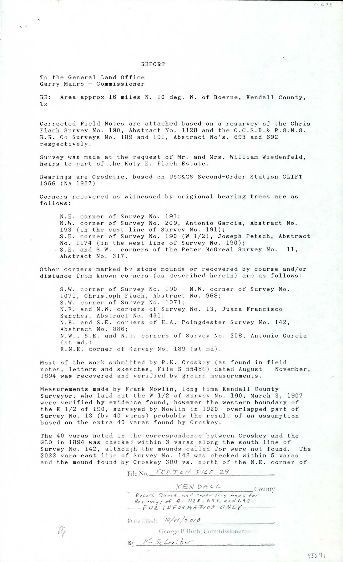
Kendall County Sketch File 29
Report, sketch, and supporting documents for resurveys of A-1128, A-693 and A-692
-
Map/Doc
95291
-
Collection
General Map Collection
-
Object Dates
7/11/1990 (Creation Date)
10/1/2018 (File Date)
8/1894 (Survey Date)
11/1894 (Survey Date)
3/3/1907 (Survey Date)
1920 (Survey Date)
-
People and Organizations
Charles Ottmers (Surveyor/Engineer)
R.K. Croskey (Surveyor/Engineer)
Frank Nowlin (Surveyor/Engineer)
-
Counties
Kendall
-
Subjects
Surveying Sketch File
-
Height x Width
14.0 x 8.5 inches
35.6 x 21.6 cm
-
Medium
multi-page, multi-format
-
Comments
Filed for information only. For plat, see Kendall County Rolled Sketch 9 (95298)
-
Features
Dunners Mountain
Darmstadt Creek
Polecat Creek
Schleicher Mountain
Los Ricos Pobres Ranch Subdivision
Upper Sisterdale County Road
Related maps
Kendall County Rolled Sketch 9

Print $20.00
- Digital $50.00
Kendall County Rolled Sketch 9
1990
Size 32.8 x 24.3 inches
Map/Doc 95298
Part of: General Map Collection
Index Map No. 1 - Rio Bravo del Norte section of boundary between the United States & Mexico; agreed upon by the Joint Commission under the Treaty of Guadalupe Hidalgo

Print $20.00
- Digital $50.00
Index Map No. 1 - Rio Bravo del Norte section of boundary between the United States & Mexico; agreed upon by the Joint Commission under the Treaty of Guadalupe Hidalgo
1852
Size 18.3 x 27.5 inches
Map/Doc 72862
Brazoria County Working Sketch 19

Print $40.00
- Digital $50.00
Brazoria County Working Sketch 19
1951
Size 50.3 x 42.3 inches
Map/Doc 67504
Starr County Rolled Sketch 20

Print $20.00
- Digital $50.00
Starr County Rolled Sketch 20
1921
Size 23.6 x 15.4 inches
Map/Doc 7804
Gregg County Rolled Sketch 11

Print $20.00
- Digital $50.00
Gregg County Rolled Sketch 11
Size 32.7 x 30.5 inches
Map/Doc 6036
Hunt County Boundary File 5

Print $6.00
- Digital $50.00
Hunt County Boundary File 5
Size 11.2 x 8.9 inches
Map/Doc 55222
Erath County Rolled Sketch 2B

Print $20.00
- Digital $50.00
Erath County Rolled Sketch 2B
Size 15.5 x 20.9 inches
Map/Doc 5863
Brazos River, Brazos River Sheet 4

Print $6.00
- Digital $50.00
Brazos River, Brazos River Sheet 4
1926
Size 19.7 x 32.0 inches
Map/Doc 65297
Flight Mission No. CRC-2R, Frame 53, Chambers County

Print $20.00
- Digital $50.00
Flight Mission No. CRC-2R, Frame 53, Chambers County
1956
Size 18.5 x 22.4 inches
Map/Doc 84726
McMullen County Working Sketch 14

Print $20.00
- Digital $50.00
McMullen County Working Sketch 14
1938
Size 28.6 x 37.1 inches
Map/Doc 70715
Liberty County Working Sketch 7

Print $20.00
- Digital $50.00
Liberty County Working Sketch 7
1906
Size 22.2 x 24.8 inches
Map/Doc 70466
San Jacinto County Sketch File 8

Print $4.00
San Jacinto County Sketch File 8
Size 10.2 x 7.9 inches
Map/Doc 35710
Erath County Working Sketch 4

Print $20.00
- Digital $50.00
Erath County Working Sketch 4
1919
Size 31.7 x 28.6 inches
Map/Doc 69085
You may also like
Crockett County Sketch File D

Print $40.00
- Digital $50.00
Crockett County Sketch File D
1903
Size 24.6 x 48.0 inches
Map/Doc 10347

Hamilton County Sketch File 24

Print $20.00
- Digital $50.00
Hamilton County Sketch File 24
1953
Size 23.2 x 22.8 inches
Map/Doc 11619
Potter County Working Sketch 6

Print $20.00
- Digital $50.00
Potter County Working Sketch 6
1959
Size 23.3 x 27.0 inches
Map/Doc 71666
Brewster County Rolled Sketch 152

Print $20.00
- Digital $50.00
Brewster County Rolled Sketch 152
1996
Size 28.0 x 36.5 inches
Map/Doc 5319
Moore County Sketch File X

Print $20.00
- Digital $50.00
Moore County Sketch File X
Size 34.3 x 24.6 inches
Map/Doc 42131
Flight Mission No. CUG-2P, Frame 69, Kleberg County

Print $20.00
- Digital $50.00
Flight Mission No. CUG-2P, Frame 69, Kleberg County
1956
Size 18.4 x 22.2 inches
Map/Doc 86206
Traced from Genl. Arista's map captured by the American Army under Genl. Taylor at Resaca de la Palma 9th May '46 and presented to James K. Polk, President U. States

Print $20.00
- Digital $50.00
Traced from Genl. Arista's map captured by the American Army under Genl. Taylor at Resaca de la Palma 9th May '46 and presented to James K. Polk, President U. States
1846
Size 18.1 x 27.3 inches
Map/Doc 73062
Comal County Sketch File 13

Print $8.00
- Digital $50.00
Comal County Sketch File 13
1866
Size 9.5 x 14.9 inches
Map/Doc 19026
Eastland County Sketch File 17

Print $18.00
- Digital $50.00
Eastland County Sketch File 17
1918
Size 13.6 x 8.9 inches
Map/Doc 21600
Jasper County Working Sketch 11

Print $20.00
- Digital $50.00
Jasper County Working Sketch 11
1917
Size 20.2 x 23.4 inches
Map/Doc 66473
Cottle County Sketch File 6c

Print $8.00
- Digital $50.00
Cottle County Sketch File 6c
Size 14.2 x 8.6 inches
Map/Doc 19480