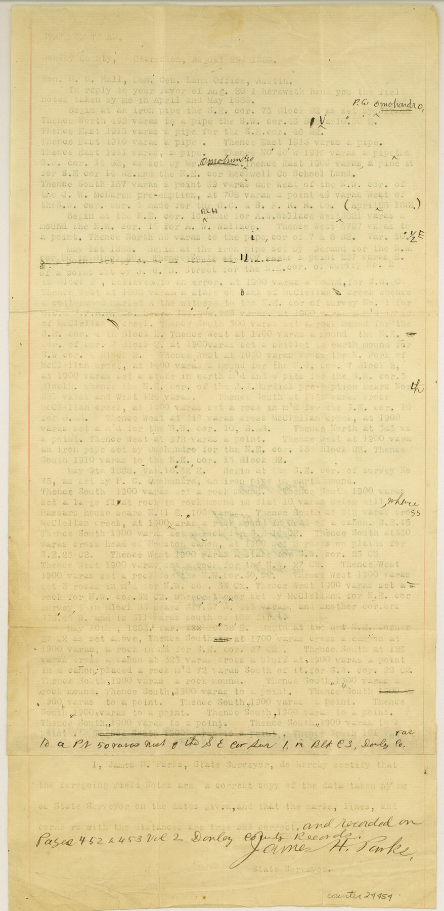
Gray County Sketch File 12
[Connections from southeast corner of survey 75, Block B2]
-
Map/Doc
24454
-
Collection
General Map Collection
-
Object Dates
1889/8/23 (Creation Date)
1889/8/26 (File Date)
-
People and Organizations
James H. Parks (Surveyor/Engineer)
-
Counties
Gray
-
Subjects
Surveying Sketch File
-
Height x Width
17.0 x 8.3 inches
43.2 x 21.1 cm
-
Medium
paper, print
-
Features
McClellan Creek
Part of: General Map Collection
Hudspeth County Working Sketch 65

Print $40.00
- Digital $50.00
Hudspeth County Working Sketch 65
2007
Size 32.9 x 61.6 inches
Map/Doc 88732
Travis County Sketch File 59

Print $28.00
- Digital $50.00
Travis County Sketch File 59
Size 14.4 x 9.0 inches
Map/Doc 38413

Upshur County Working Sketch Graphic Index

Print $20.00
- Digital $50.00
Upshur County Working Sketch Graphic Index
1945
Size 40.8 x 35.4 inches
Map/Doc 76720
Randall County Boundary File 3

Print $8.00
- Digital $50.00
Randall County Boundary File 3
Size 14.3 x 8.8 inches
Map/Doc 58125
Henderson County Working Sketch 19

Print $20.00
- Digital $50.00
Henderson County Working Sketch 19
1947
Size 18.6 x 20.3 inches
Map/Doc 66152
Crane County Sketch File 23

Print $20.00
- Digital $50.00
Crane County Sketch File 23
1931
Size 21.3 x 39.1 inches
Map/Doc 11211
Comanche County Sketch File 22a

Print $2.00
- Digital $50.00
Comanche County Sketch File 22a
Size 8.2 x 7.6 inches
Map/Doc 19108
Flight Mission No. CRC-2R, Frame 196, Chambers County

Print $20.00
- Digital $50.00
Flight Mission No. CRC-2R, Frame 196, Chambers County
1956
Size 18.7 x 22.4 inches
Map/Doc 84774
Reconnoissances of Routes from San Antonio de Bexar, El Paso del Norte &c &c

Print $20.00
- Digital $50.00
Reconnoissances of Routes from San Antonio de Bexar, El Paso del Norte &c &c
1849
Size 26.3 x 38.9 inches
Map/Doc 94853
El Paso County Boundary File 17

Print $8.00
- Digital $50.00
El Paso County Boundary File 17
Size 13.4 x 8.4 inches
Map/Doc 53192
Hydrographic Survey H-1288B Corpus Christi Pass
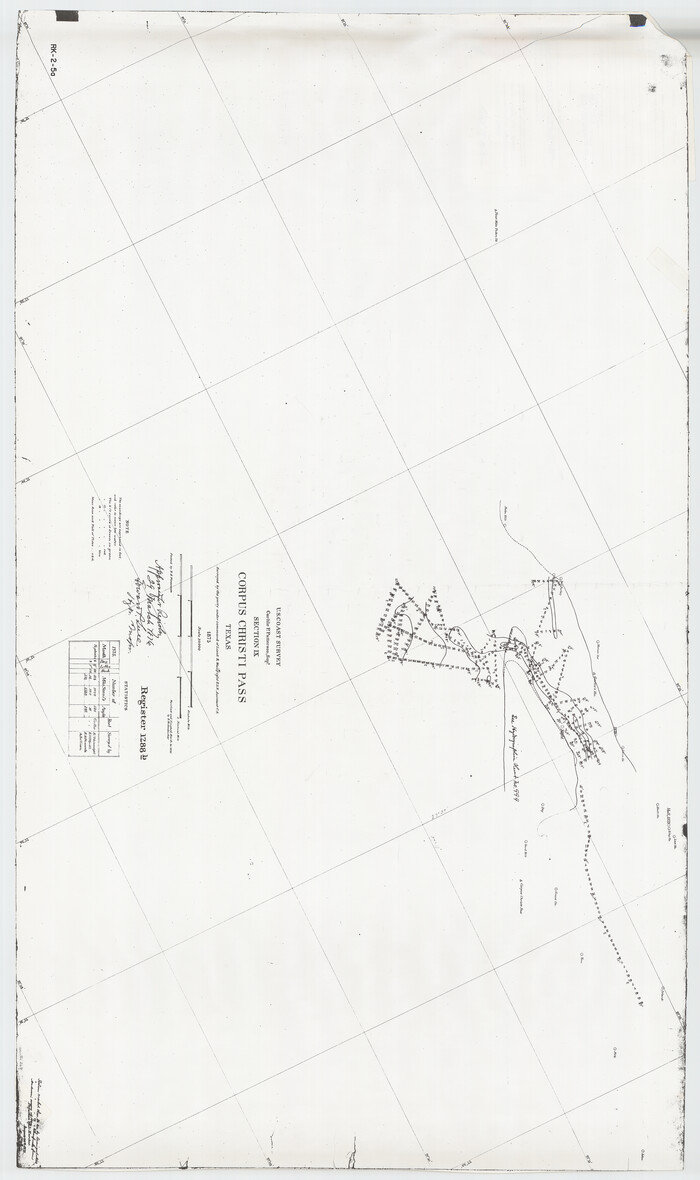
Print $40.00
- Digital $50.00
Hydrographic Survey H-1288B Corpus Christi Pass
1875
Size 52.9 x 31.4 inches
Map/Doc 2691
You may also like
Dallas/Fort Worth Street Map & Visitor Guide

Dallas/Fort Worth Street Map & Visitor Guide
2000
Size 35.5 x 23.1 inches
Map/Doc 94296
Freestone County Sketch File 15

Print $4.00
- Digital $50.00
Freestone County Sketch File 15
Size 6.3 x 8.2 inches
Map/Doc 23070
San Jacinto County Sketch File 8

Print $4.00
San Jacinto County Sketch File 8
Size 10.2 x 7.9 inches
Map/Doc 35710
Hartley County Working Sketch 2

Print $20.00
- Digital $50.00
Hartley County Working Sketch 2
1920
Size 41.8 x 30.7 inches
Map/Doc 66052
Part of a map showing resurvey of Capitol Leagues by R. S. Hunnicutt & Behn Cook State Surveyors

Print $20.00
- Digital $50.00
Part of a map showing resurvey of Capitol Leagues by R. S. Hunnicutt & Behn Cook State Surveyors
Size 21.6 x 17.3 inches
Map/Doc 90277
Zavala County Rolled Sketch 32

Print $20.00
- Digital $50.00
Zavala County Rolled Sketch 32
Size 22.5 x 38.2 inches
Map/Doc 8333
Orange County Working Sketch 20

Print $20.00
- Digital $50.00
Orange County Working Sketch 20
1933
Size 16.0 x 23.3 inches
Map/Doc 71352
Bosque County Working Sketch 4

Print $20.00
- Digital $50.00
Bosque County Working Sketch 4
1901
Size 14.2 x 18.6 inches
Map/Doc 67437
[Surveying Sketch of Part of] Maverick County
![515, [Surveying Sketch of Part of] Maverick County, Maddox Collection](https://historictexasmaps.com/wmedia_w700/maps/515.tif.jpg)
Print $3.00
- Digital $50.00
[Surveying Sketch of Part of] Maverick County
1878
Size 9.8 x 13.2 inches
Map/Doc 515
Flight Mission No. BRA-16M, Frame 166, Jefferson County

Print $20.00
- Digital $50.00
Flight Mission No. BRA-16M, Frame 166, Jefferson County
1953
Size 18.5 x 22.3 inches
Map/Doc 85764
Coke County Working Sketch 17

Print $20.00
- Digital $50.00
Coke County Working Sketch 17
1948
Size 18.2 x 19.4 inches
Map/Doc 68054
Kinney County Rolled Sketch 21

Print $40.00
- Digital $50.00
Kinney County Rolled Sketch 21
1992
Size 39.2 x 57.2 inches
Map/Doc 9358