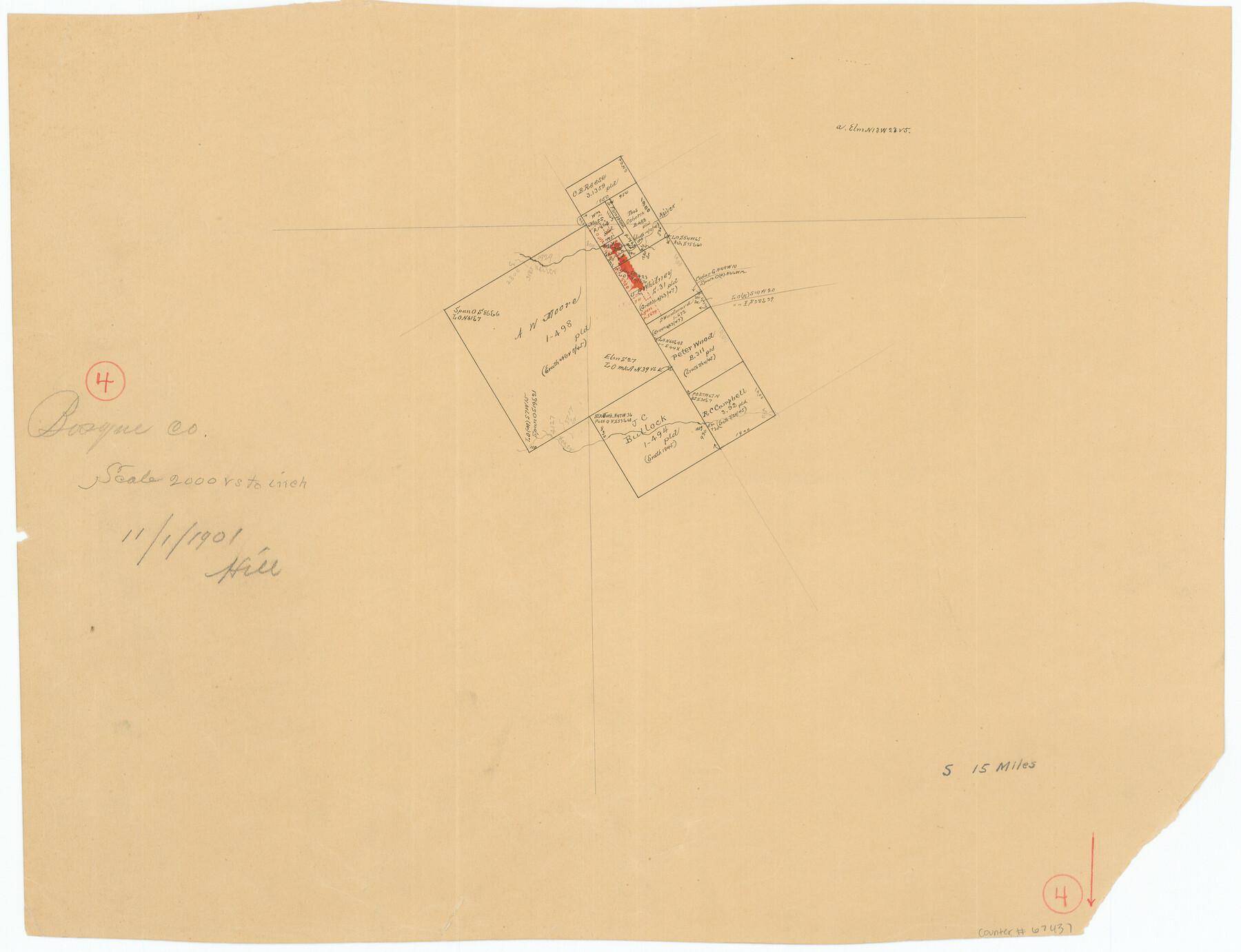
Bosque County Working Sketch 4
-
Map/Doc
67437
-
Collection
General Map Collection
-
Object Dates
11/1/1901 (Creation Date)
-
Counties
Bosque
-
Subjects
Surveying Working Sketch
-
Height x Width
14.2 x 18.6 inches
36.1 x 47.2 cm
-
Scale
1" = 2000 varas
-
Comments
Surveys located about 15 miles South of Meridian, Texas.
Part of: General Map Collection
Lynn County Rolled Sketch 13

Print $20.00
- Digital $50.00
Lynn County Rolled Sketch 13
Size 36.2 x 24.7 inches
Map/Doc 6649
Blanco County Sketch File 28

Print $40.00
- Digital $50.00
Blanco County Sketch File 28
1888
Size 13.8 x 13.2 inches
Map/Doc 14623
[Surveys in Polk and Tyler Counties, Liberty District]
![354, [Surveys in Polk and Tyler Counties, Liberty District], General Map Collection](https://historictexasmaps.com/wmedia_w700/maps/354.tif.jpg)
Print $2.00
- Digital $50.00
[Surveys in Polk and Tyler Counties, Liberty District]
1847
Size 10.8 x 8.1 inches
Map/Doc 354
Tom Green County Rolled Sketch 25

Print $20.00
- Digital $50.00
Tom Green County Rolled Sketch 25
1882
Size 14.0 x 18.5 inches
Map/Doc 8007

Geological Report on Robertson County

Print $20.00
- Digital $50.00
Geological Report on Robertson County
1918
Size 21.7 x 25.8 inches
Map/Doc 97084
Parker County Working Sketch 17

Print $20.00
- Digital $50.00
Parker County Working Sketch 17
1996
Map/Doc 71467
Presidio County Working Sketch 86

Print $20.00
- Digital $50.00
Presidio County Working Sketch 86
1971
Size 45.4 x 42.2 inches
Map/Doc 71763
Morris County Rolled Sketch 2

Print $40.00
- Digital $50.00
Morris County Rolled Sketch 2
1944
Size 59.4 x 43.5 inches
Map/Doc 9550
Coryell County Sketch File 3

Print $4.00
- Digital $50.00
Coryell County Sketch File 3
1852
Size 8.3 x 10.1 inches
Map/Doc 19340
Flight Mission No. DQO-3K, Frame 22, Galveston County

Print $20.00
- Digital $50.00
Flight Mission No. DQO-3K, Frame 22, Galveston County
1952
Size 18.8 x 22.5 inches
Map/Doc 85063
Flight Mission No. DQN-5K, Frame 60, Calhoun County

Print $20.00
- Digital $50.00
Flight Mission No. DQN-5K, Frame 60, Calhoun County
1953
Size 15.5 x 15.4 inches
Map/Doc 84403
You may also like
Presidio County Sketch File P2

Print $6.00
- Digital $50.00
Presidio County Sketch File P2
Size 14.3 x 8.9 inches
Map/Doc 34558
Flight Mission No. BRE-1P, Frame 5, Nueces County

Print $20.00
- Digital $50.00
Flight Mission No. BRE-1P, Frame 5, Nueces County
1956
Size 18.3 x 22.1 inches
Map/Doc 86613
Andrews County Working Sketch 15

Print $40.00
- Digital $50.00
Andrews County Working Sketch 15
1957
Size 50.5 x 36.1 inches
Map/Doc 67061

Edwards County Working Sketch 109

Print $40.00
- Digital $50.00
Edwards County Working Sketch 109
1972
Size 51.8 x 37.6 inches
Map/Doc 68985
Dimmit County Working Sketch 16

Print $20.00
- Digital $50.00
Dimmit County Working Sketch 16
1943
Size 25.6 x 24.8 inches
Map/Doc 68677
Presidio County Rolled Sketch 59

Print $20.00
- Digital $50.00
Presidio County Rolled Sketch 59
Size 27.6 x 18.2 inches
Map/Doc 7352
Harrison County Rolled Sketch 6

Print $20.00
- Digital $50.00
Harrison County Rolled Sketch 6
1952
Size 23.4 x 24.2 inches
Map/Doc 6152
Frio County Rolled Sketch 3

Print $20.00
- Digital $50.00
Frio County Rolled Sketch 3
Size 30.7 x 20.1 inches
Map/Doc 5916
Bowie County Sketch File 6

Print $10.00
- Digital $50.00
Bowie County Sketch File 6
1927
Size 8.5 x 4.0 inches
Map/Doc 14839
Kinney County Working Sketch 37

Print $20.00
- Digital $50.00
Kinney County Working Sketch 37
1971
Size 25.7 x 21.7 inches
Map/Doc 70219
Flight Mission No. DCL-6C, Frame 122, Kenedy County

Print $20.00
- Digital $50.00
Flight Mission No. DCL-6C, Frame 122, Kenedy County
1943
Size 18.5 x 22.4 inches
Map/Doc 85952