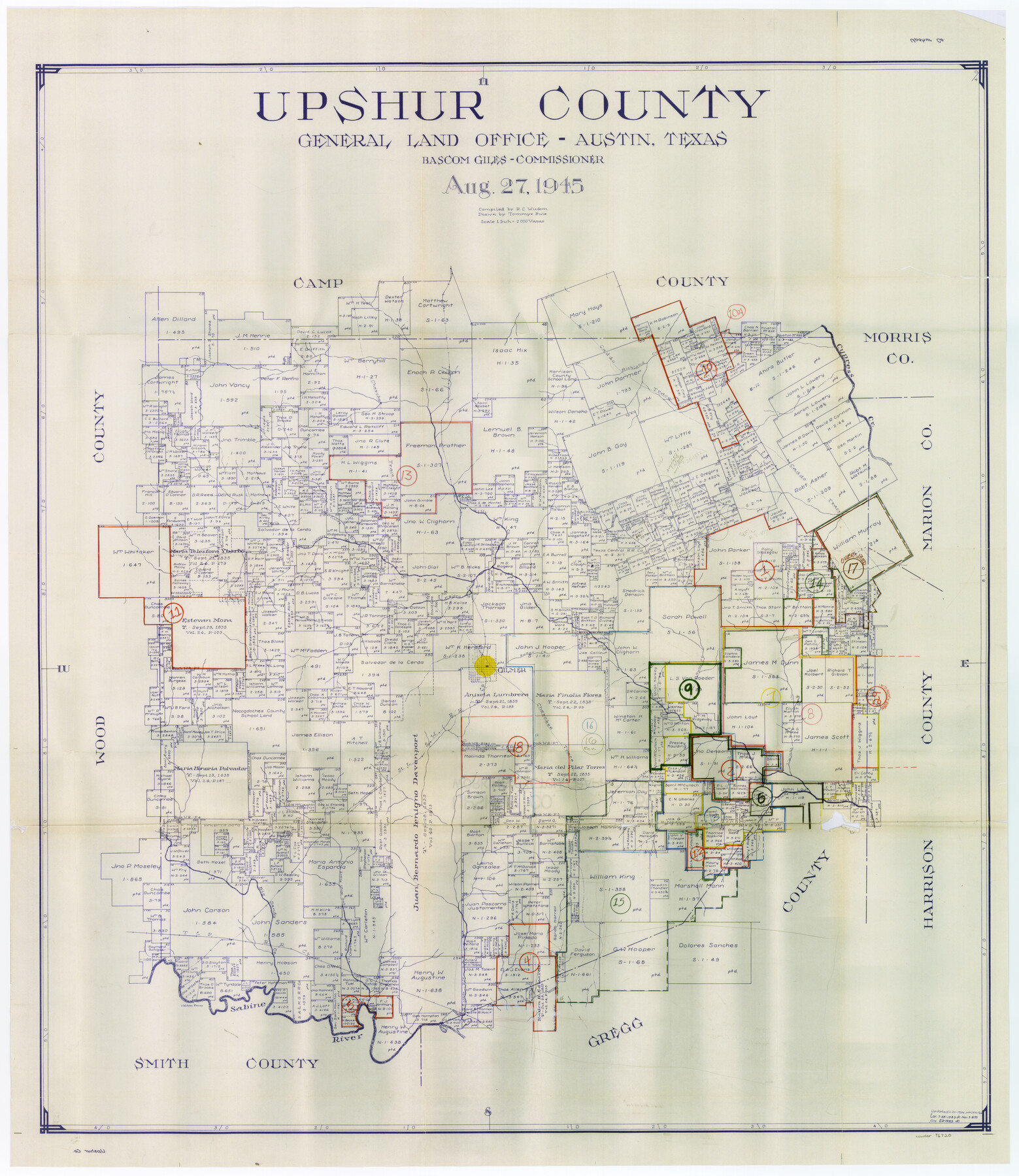
Upshur County Working Sketch Graphic Index
-
Map/Doc
76720
-
Collection
General Map Collection
-
Object Dates
8/27/1945 (Creation Date)
-
People and Organizations
R.C. Wisdom (Compiler)
Tommye Buie (Draftsman)
-
Counties
Upshur
-
Subjects
County Surveying Working Sketch
-
Height x Width
40.8 x 35.4 inches
103.6 x 89.9 cm
-
Scale
1" = 2000 varas
Part of: General Map Collection
Flight Mission No. DQO-3K, Frame 40, Galveston County

Print $20.00
- Digital $50.00
Flight Mission No. DQO-3K, Frame 40, Galveston County
1952
Size 18.8 x 22.4 inches
Map/Doc 85081
[Maps of surveys in Reeves & Culberson Cos]
![61130, [Maps of surveys in Reeves & Culberson Cos], General Map Collection](https://historictexasmaps.com/wmedia_w700/maps/61130.tif.jpg)
Print $20.00
- Digital $50.00
[Maps of surveys in Reeves & Culberson Cos]
1937
Size 30.7 x 24.9 inches
Map/Doc 61130
Calhoun County Working Sketch 3

Print $20.00
- Digital $50.00
Calhoun County Working Sketch 3
1923
Size 18.4 x 42.4 inches
Map/Doc 67819
Texas Intracoastal Waterway - Laguna Madre - Rincon de San Jose to Chubby Island

Print $20.00
- Digital $50.00
Texas Intracoastal Waterway - Laguna Madre - Rincon de San Jose to Chubby Island
1961
Size 38.0 x 26.7 inches
Map/Doc 73514
PSL Field Notes for Blocks 87 through 98 in Culberson County

PSL Field Notes for Blocks 87 through 98 in Culberson County
Map/Doc 81664
Galveston County Aerial Photograph Index Sheet 2

Print $20.00
- Digital $50.00
Galveston County Aerial Photograph Index Sheet 2
1953
Size 21.2 x 19.5 inches
Map/Doc 83693
Fayette County Working Sketch 5

Print $20.00
- Digital $50.00
Fayette County Working Sketch 5
1981
Size 16.2 x 14.6 inches
Map/Doc 69169
Red River County Working Sketch 59

Print $20.00
- Digital $50.00
Red River County Working Sketch 59
1972
Size 31.1 x 47.2 inches
Map/Doc 72042
Flight Mission No. DQN-2K, Frame 117, Calhoun County

Print $20.00
- Digital $50.00
Flight Mission No. DQN-2K, Frame 117, Calhoun County
1953
Size 18.3 x 22.1 inches
Map/Doc 84293
Montague County Sketch File 13

Print $4.00
- Digital $50.00
Montague County Sketch File 13
1879
Size 8.9 x 9.0 inches
Map/Doc 31738
Liberty County Sketch File 28

Print $6.00
- Digital $50.00
Liberty County Sketch File 28
Size 5.2 x 8.0 inches
Map/Doc 29952
Galveston County NRC Article 33.136 Sketch 4

Print $406.00
- Digital $50.00
Galveston County NRC Article 33.136 Sketch 4
2001
Size 22.7 x 34.1 inches
Map/Doc 61568
You may also like
Stephens County Working Sketch 17

Print $20.00
- Digital $50.00
Stephens County Working Sketch 17
1968
Size 22.7 x 29.1 inches
Map/Doc 63960

Map of Parmer County

Print $20.00
- Digital $50.00
Map of Parmer County
1900
Size 47.8 x 41.3 inches
Map/Doc 16786
Flight Mission No. CGI-3N, Frame 70, Cameron County

Print $20.00
- Digital $50.00
Flight Mission No. CGI-3N, Frame 70, Cameron County
1954
Size 18.7 x 22.3 inches
Map/Doc 84564
Map of Spearman Lands

Print $20.00
- Digital $50.00
Map of Spearman Lands
Size 20.1 x 15.3 inches
Map/Doc 90791
Gillespie County Sketch File 13

Print $4.00
- Digital $50.00
Gillespie County Sketch File 13
1878
Size 8.4 x 10.9 inches
Map/Doc 24153
Dallas County Boundary File 8 and 8a

Print $4.00
- Digital $50.00
Dallas County Boundary File 8 and 8a
Size 11.2 x 8.7 inches
Map/Doc 52311
Hardin County Sketch File 11

Print $8.00
- Digital $50.00
Hardin County Sketch File 11
Size 5.2 x 8.2 inches
Map/Doc 25112
Railroad and County Map of Texas

Print $20.00
Railroad and County Map of Texas
1893
Size 24.2 x 27.2 inches
Map/Doc 76255
Map of Portion of Laguna Madre in Nueces & Kleberg Counties showing subdivision thereof for mineral development

Print $20.00
- Digital $50.00
Map of Portion of Laguna Madre in Nueces & Kleberg Counties showing subdivision thereof for mineral development
1937
Size 38.6 x 30.8 inches
Map/Doc 2918
Somervell County Rolled Sketch D

Print $20.00
- Digital $50.00
Somervell County Rolled Sketch D
1939
Size 17.3 x 21.0 inches
Map/Doc 7794
![91463, [Block B7], Twichell Survey Records](https://historictexasmaps.com/wmedia_w700/maps/91463-1.tif.jpg)