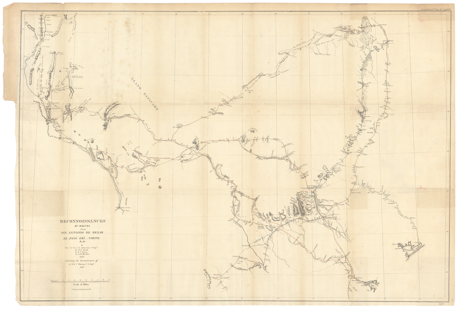
Reconnoissances of Routes from San Antonio de Bexar, El Paso del Norte &c &c
-
Map/Doc
94853
-
Collection
General Map Collection
-
Object Dates
1849 (Creation Date)
-
People and Organizations
P.S. Duval's Lith. Steam Press Plat (Printer)
J.E. Johnston (Surveyor/Engineer)
W.F. Smith (Surveyor/Engineer)
F.T. Bryan (Surveyor/Engineer)
N.H. Michler (Surveyor/Engineer)
W.H.C. Whiting (Surveyor/Engineer)
-
Subjects
Military State of Texas
-
Height x Width
26.3 x 38.9 inches
66.8 x 98.8 cm
-
Medium
paper, etching/engraving/lithograph
-
Comments
This map was published in Senate Ex. Doc. 64, 31st Congress, 1st Session. To view/download this report, please click the "Download PDF" link above.
-
Features
Fort Inge
Chicon Creek
La Mina Creek
Saladina Creek
Picoso Creek
Chaperoso Creek
Las Cuevas Creek
Leona River
Lower Presidio Road
Laredo Road
Table Hills
Upper Presidio Road
Rio Seco
Camp Lincoln
Ranchero Creek
Rio Sabinal
Parker's Creek
Rio Hondo
Vandenburg
Quihi
Quihi Creek
Castroville
Medina River
Wells Road
San Geronimo Creek
Rangers Camp
Sans Creek
Petranco Creek
Medio Creek
Leon Creek
San Antonio de Bexar
S[anta] Clara Creek
Calaveras Creek
San Antonio River
Eagle Creek
Marcelina Creek
S[an] Fernando Creek
Agua Dulce
Oso Creek
Corpus Christi
Corpus Christi Bay
Nueces Bay
Baranca Blanca
Lipantitlan
San Patricio
Casa Blanca Creek
La Sarca Creek
Radamenia Creek
Arteceoasa Creek
Cleto Creek
Guadalupe River
New Braunsfels
San Marco [sic] Creek
Manchac's [sic] Spring
Onion Creek
Austin
Colorado River
Walnut Creek
Brushy Creek
Fort Croghan
Old Cantonment Rangers
San Gabriel River
Rio Grande
Capt. Marcy's route
White Sand Hills
Hueco Tanks
El Paso del Norte
Sierra Hueca
Socorro
Sierra Blanca
Lieuts. Smith & Whiting's Trail
Sand Hills
Salt Creek
Llano Estacado
Guadalupe Springs
Head springs of Delaware Creek
Delaware Creek
Salinas Creek
Toyah Creek
Rain Water Creek
Running Water Creek
Fort Leaton
Rio Conchos
Leon Spring
Ojo Escondido
Comanche Trail to Mexico
Horsehead Crossing [of Pecos River]
Rio Pecos
Connelly's trail
Wild China Ponds
Flatrock Ponds
Live Oak Creek
Howards Spring
S[an] Juan
Fort Duncan
Las Moras Creek
Maverick's Creek
San Pedro Creek
San Felipe Creek
Rio San Pedro
Zoquete Creek
Indian Trail from Las Moras
Green Mounds
Good Spring Creek
South Concho River
North Concho River
Kioway Creek
Logan Camp Creek
Dove Creek
Emigrants Route
Antelope Creek
San Saba River
Lipan Creek
Potato Spring
Kickapoo Creek
Twin Mountains
San Saba Ford
Brady's Creek
Road to El Paso
Rio Nueces
Rio Frio
North Fork of San Gabriel River
South Fork of San Gabriel River
Berry's Fork [of San Gabriel River]
Salado Creek
Little River
Lampasos [sic] Creek
Cow House River
Noland's Creek
Cedar Creek
Elm Creek
Cow Bayou
Cow Creek
Mustang Ponds
Lavaca Bay
Comanche Creek
Puerto de Paisana
Reconnaissance Nov. 1849
Bandera Pass
Sabinal Creek
Wasp Creek
Fort Martin Scott
Fredericksburg
Rio Pierdenales [sic]
Blanco Creek
Grape Creek
Threadvill's Creek
Lipan Camp Creek
South Branch of Brady's Creek
Rock Creek
Double Mountain Fork of Brasos [sic] River
Branches of Clear Fork [Creek]
Nowland's River
Bois D'Arc Creek
Dallas
Big Wichita River
Beaver Grove
Warren's Trading Post
Extreme border settlement
Walnut Bayou
Caddo Creek
McCarty's Creek
Post on the Leona River
Sierra Guadalupe
South Fork of Cow Creek
North Fork of Cow Creek
Waco Village
Rio Leon
Fort Gates
Middle Bosque River
Hog Creek
North Bosque River
Brasos [sic] River
Childers Creek
Aguila Creek
Old Towash Village
Richland Creek
Ash Creek
Pecos Creek
North Fork of Richland Creek
Buffalo Creek
Mill Creek
Navarro
Chamber's Creek
Wakahachi [sic] Creek
Clear Fork of Trinity River
Fort Worth
West Fork of Trinity River
Trinity River
Pleasant Run Creek
White Rock Creek
Hickory Creek
Rowlett's Creek
Ten Mile Creek
Honey Creek
Lieut. Whiting's Route
Elm Fork of Trinity River
Extreme border settlement
Little Wichita River
Capt. Marcy's return route
Waggon [sic] Road
Fitzhue Station
Red River
Big Mineral Creek
Little Mineral Creek
Preston
False Washita River
Gilleland's Creek
Webber's Prairie
Wilbarger's Creek
Sandy Creek
Piney Creek
Bastrop
Gazley's Creek
Buckner's
Rocky Creek
Lagrange [sic]
Rabb's Creek
Rabb's Bluff
Williams Creek
Harvey Creek
Columbus
Scull [sic] Creek
Wharton
Jones Creek
Blue Creek
Jennings Creek
Matagorda Bay
Lavacca [sic]
Lavacca [sic] Point
Matagorda
Part of: General Map Collection
Brooks County Rolled Sketch 25

Print $20.00
- Digital $50.00
Brooks County Rolled Sketch 25
1945
Size 21.6 x 26.4 inches
Map/Doc 5345
Nueces County Rolled Sketch 42

Print $45.00
Nueces County Rolled Sketch 42
1970
Size 27.6 x 39.2 inches
Map/Doc 6880
Pecos County Sketch File 93

Print $46.00
- Digital $50.00
Pecos County Sketch File 93
1955
Size 9.6 x 8.3 inches
Map/Doc 33990
Upshur County Sketch File 2a

Print $4.00
- Digital $50.00
Upshur County Sketch File 2a
Size 12.9 x 8.2 inches
Map/Doc 38734
Childress County Rolled Sketch 9A

Print $20.00
- Digital $50.00
Childress County Rolled Sketch 9A
Size 17.0 x 17.1 inches
Map/Doc 5447
[Galveston, Harrisburg & San Antonio Railroad from Cuero to Stockdale]
![64201, [Galveston, Harrisburg & San Antonio Railroad from Cuero to Stockdale], General Map Collection](https://historictexasmaps.com/wmedia_w700/maps/64201.tif.jpg)
Print $20.00
- Digital $50.00
[Galveston, Harrisburg & San Antonio Railroad from Cuero to Stockdale]
1907
Size 14.3 x 34.3 inches
Map/Doc 64201
Bastrop County Sketch File 11

Print $52.00
- Digital $50.00
Bastrop County Sketch File 11
Size 11.2 x 8.7 inches
Map/Doc 14058
Flight Mission No. CUG-3P, Frame 141, Kleberg County

Print $20.00
- Digital $50.00
Flight Mission No. CUG-3P, Frame 141, Kleberg County
1956
Size 18.4 x 22.2 inches
Map/Doc 86276
Kent County Rolled Sketch A

Print $20.00
- Digital $50.00
Kent County Rolled Sketch A
1902
Size 23.9 x 36.8 inches
Map/Doc 6477
McLennan County Working Sketch 8

Print $20.00
- Digital $50.00
McLennan County Working Sketch 8
1974
Size 34.1 x 30.6 inches
Map/Doc 70701
Presidio County Sketch File 85

Print $6.00
- Digital $50.00
Presidio County Sketch File 85
1950
Size 14.3 x 8.9 inches
Map/Doc 34745
Coke County Sketch File 21

Print $20.00
- Digital $50.00
Coke County Sketch File 21
1911
Size 12.6 x 14.0 inches
Map/Doc 18614
You may also like
Part of Tom Green County, Texas (No. 2)

Print $20.00
- Digital $50.00
Part of Tom Green County, Texas (No. 2)
1870
Size 22.9 x 18.0 inches
Map/Doc 5046
Red River County Sketch File 5a

Print $2.00
- Digital $50.00
Red River County Sketch File 5a
Size 4.7 x 6.6 inches
Map/Doc 35104
Galveston County Rolled Sketch 46

Print $40.00
- Digital $50.00
Galveston County Rolled Sketch 46
2000
Size 32.0 x 48.3 inches
Map/Doc 5981
Current Miscellaneous File 104

Print $8.00
- Digital $50.00
Current Miscellaneous File 104
1845
Size 11.0 x 16.8 inches
Map/Doc 74677
Texas in 1840, or the Emigrant's Guide to the New Republic; being the result of observation, enquiry and travel in that beautiful country

Texas in 1840, or the Emigrant's Guide to the New Republic; being the result of observation, enquiry and travel in that beautiful country
1840
Map/Doc 97198
Fisher County Sketch File 23

Print $12.00
- Digital $50.00
Fisher County Sketch File 23
1875
Size 10.8 x 8.2 inches
Map/Doc 22660
Terry County Sketch File 1

Print $20.00
- Digital $50.00
Terry County Sketch File 1
1903
Size 25.7 x 23.4 inches
Map/Doc 12428
Crockett County Working Sketch 67

Print $20.00
- Digital $50.00
Crockett County Working Sketch 67
1959
Size 26.5 x 31.5 inches
Map/Doc 68400

Cherokee County Sketch File 6

Print $22.00
- Digital $50.00
Cherokee County Sketch File 6
1852
Size 12.4 x 16.4 inches
Map/Doc 18126
Runnels County Working Sketch 30a

Print $20.00
- Digital $50.00
Runnels County Working Sketch 30a
1959
Size 23.3 x 25.4 inches
Map/Doc 63626
Live Oak County Working Sketch 3

Print $20.00
- Digital $50.00
Live Oak County Working Sketch 3
1910
Size 21.5 x 19.0 inches
Map/Doc 70588