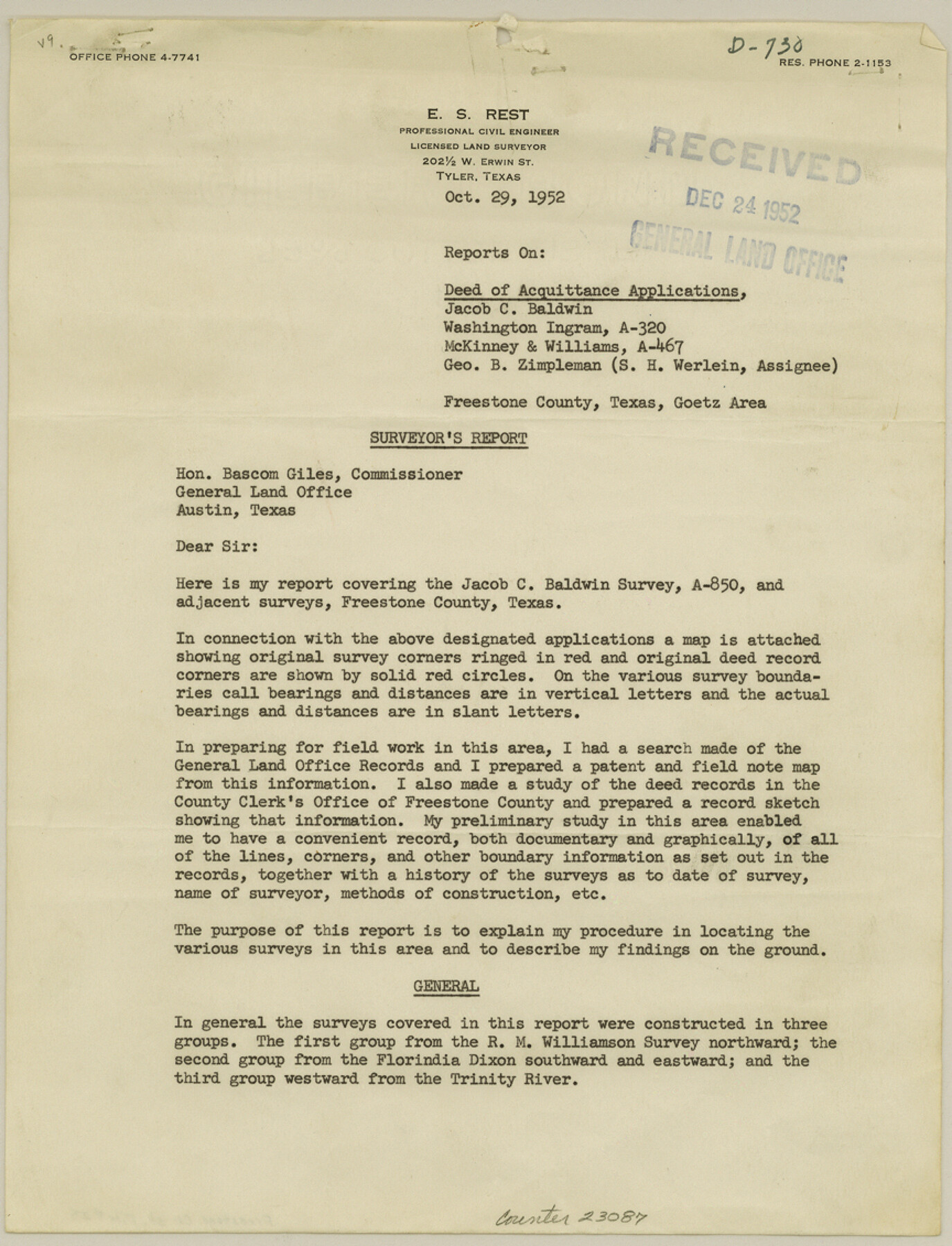
Freestone County Sketch File 25
Reports on Deed of Acquittance applications, James C. Baldwin, Washington Ingram, A-320, McKinney & Williams, A-467, Geo. B. Zimpleman (S.H. Werlein, assignee)
-
Map/Doc
23087
-
Collection
General Map Collection
-
Object Dates
1952/10/29 (Creation Date)
1952/12/24 (File Date)
-
People and Organizations
E.S. Rest (Surveyor/Engineer)
C.W. Love (Surveyor/Engineer)
B.B. Hammett (Surveyor/Engineer)
John Longbridge (Surveyor/Engineer)
-
Counties
Freestone
-
Subjects
Surveying Sketch File
-
Height x Width
11.3 x 8.6 inches
28.7 x 21.8 cm
-
Medium
paper, print
-
Comments
See Freestone County Rolled Sketch 2 (5910) for sketch.
-
Features
Trinity River
Lindsey Slough
Richland Creek
Related maps
Freestone County Rolled Sketch 2

Print $20.00
- Digital $50.00
Freestone County Rolled Sketch 2
1952
Size 27.1 x 30.2 inches
Map/Doc 5910
Part of: General Map Collection
Hardeman County Sketch File 33

Print $3.00
- Digital $50.00
Hardeman County Sketch File 33
1986
Size 17.7 x 11.7 inches
Map/Doc 25070
Motley County Sketch File 18 (N)

Print $4.00
- Digital $50.00
Motley County Sketch File 18 (N)
1913
Size 11.3 x 8.7 inches
Map/Doc 32062
Edwards County Sketch File 11

Print $26.00
- Digital $50.00
Edwards County Sketch File 11
1887
Size 13.7 x 8.8 inches
Map/Doc 21687
Sketch of surveys on Deer Creek, Milam District

Print $2.00
- Digital $50.00
Sketch of surveys on Deer Creek, Milam District
1846
Size 7.8 x 10.9 inches
Map/Doc 76046

Williamson County

Print $20.00
- Digital $50.00
Williamson County
1872
Size 18.4 x 28.2 inches
Map/Doc 4151
Sabine County Sketch File 6a

Print $4.00
Sabine County Sketch File 6a
1878
Size 8.1 x 12.5 inches
Map/Doc 35615
McMullen County Working Sketch 26

Print $20.00
- Digital $50.00
McMullen County Working Sketch 26
1953
Size 17.8 x 14.5 inches
Map/Doc 70727
Map of Martin County Texas

Print $20.00
- Digital $50.00
Map of Martin County Texas
1880
Size 22.6 x 19.0 inches
Map/Doc 4592
Galveston County Sketch File 51

Print $20.00
- Digital $50.00
Galveston County Sketch File 51
1895
Size 25.7 x 40.2 inches
Map/Doc 10457
Callahan County

Print $20.00
- Digital $50.00
Callahan County
1918
Size 44.6 x 40.2 inches
Map/Doc 4900
Fayette County Boundary File 8

Print $19.00
- Digital $50.00
Fayette County Boundary File 8
Size 14.4 x 9.0 inches
Map/Doc 53402
You may also like
Williamson County Sketch File 30

Print $20.00
- Digital $50.00
Williamson County Sketch File 30
Size 24.6 x 18.7 inches
Map/Doc 12696
North America corrected from the observations communicated to the Royal Society at London and the Royal Academy at Paris

Print $20.00
- Digital $50.00
North America corrected from the observations communicated to the Royal Society at London and the Royal Academy at Paris
1710
Size 38.9 x 26.9 inches
Map/Doc 93820
Railroad Track Map, T&PRRCo., Culberson County, Texas

Print $4.00
- Digital $50.00
Railroad Track Map, T&PRRCo., Culberson County, Texas
1910
Size 11.7 x 18.6 inches
Map/Doc 62829
Texas and Northern Mexico

Print $20.00
- Digital $50.00
Texas and Northern Mexico
1925
Size 21.0 x 28.3 inches
Map/Doc 95900
Deaf Smith County

Print $40.00
- Digital $50.00
Deaf Smith County
1926
Size 41.4 x 54.3 inches
Map/Doc 1816
Nacogdoches County Sketch File 15

Print $10.00
- Digital $50.00
Nacogdoches County Sketch File 15
1926
Size 11.2 x 8.7 inches
Map/Doc 32262
Flight Mission No. CUG-1P, Frame 20, Kleberg County

Print $20.00
- Digital $50.00
Flight Mission No. CUG-1P, Frame 20, Kleberg County
1956
Size 18.6 x 22.4 inches
Map/Doc 86110
Portion of States Submerged Area in Matagorda Bay

Print $20.00
- Digital $50.00
Portion of States Submerged Area in Matagorda Bay
1923
Size 12.7 x 13.5 inches
Map/Doc 2956
Map of the River Sabine from its mouth on the Gulf of Mexico in the Sea to Logan's Ferry in Latitude 31°58'24" North

Print $40.00
- Digital $50.00
Map of the River Sabine from its mouth on the Gulf of Mexico in the Sea to Logan's Ferry in Latitude 31°58'24" North
1842
Size 67.6 x 30.6 inches
Map/Doc 87152
General Highway Map. Detail of Cities and Towns in Bastrop County, Texas [Bastrop, Smithville, Elgin, etc.]
![79362, General Highway Map. Detail of Cities and Towns in Bastrop County, Texas [Bastrop, Smithville, Elgin, etc.], Texas State Library and Archives](https://historictexasmaps.com/wmedia_w700/maps/79362.tif.jpg)
Print $20.00
General Highway Map. Detail of Cities and Towns in Bastrop County, Texas [Bastrop, Smithville, Elgin, etc.]
1961
Size 18.3 x 25.0 inches
Map/Doc 79362
Brazos River Conservation and Reclamation District Official Boundary Line Survey

Print $20.00
- Digital $50.00
Brazos River Conservation and Reclamation District Official Boundary Line Survey
1931
Size 25.1 x 36.9 inches
Map/Doc 90125
Jefferson County NRC Article 33.136 Sketch 12

Print $22.00
- Digital $50.00
Jefferson County NRC Article 33.136 Sketch 12
2017
Size 24.0 x 36.0 inches
Map/Doc 95055