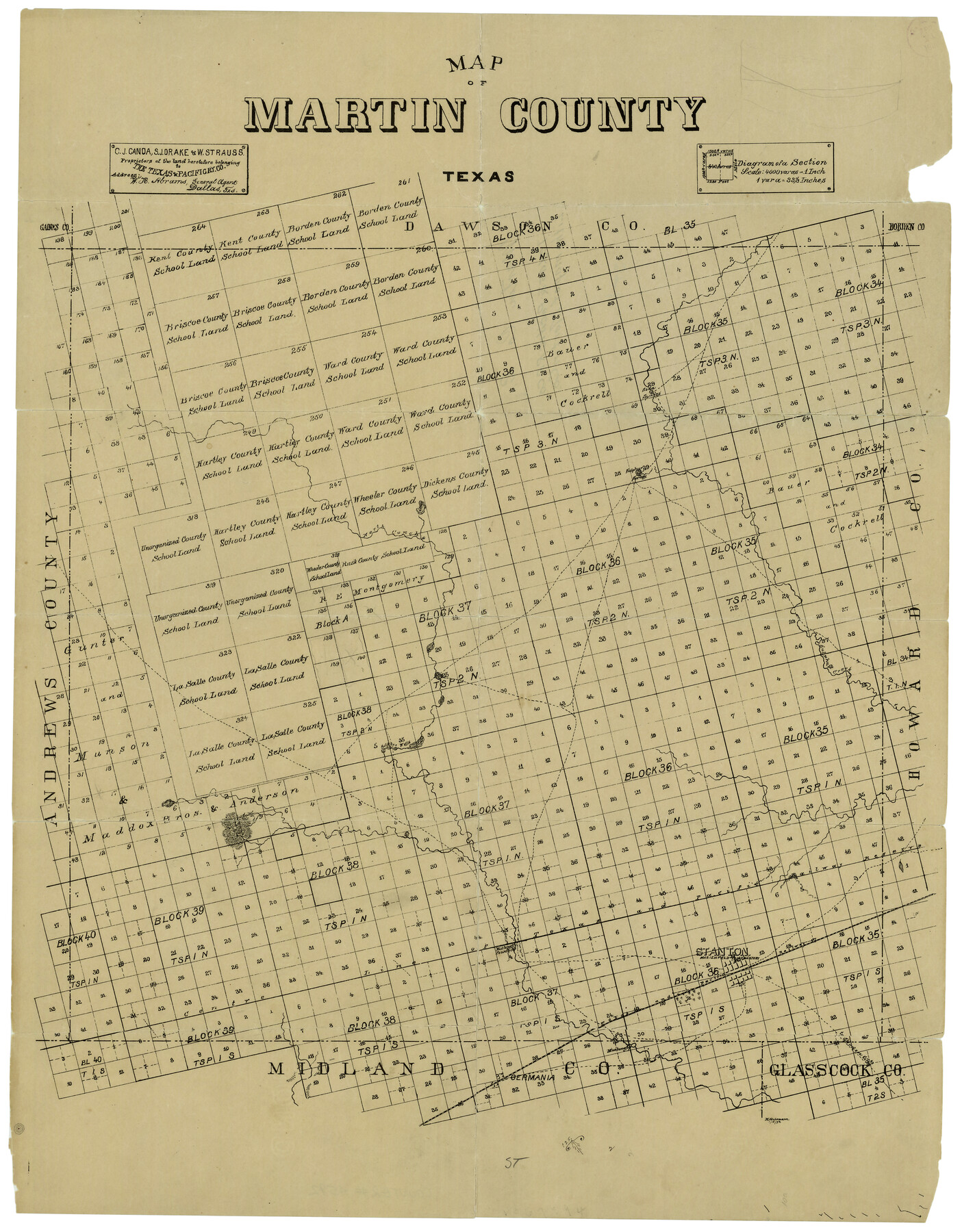
Map of Martin County Texas
Martin County Sketch File 2
-
Map/Doc
4592
-
Collection
General Map Collection
-
Object Dates
[1880 ca.] (Creation Date)
-
People and Organizations
C. J. Canda, S. J.Drake, and W. Strauss (Publisher)
-
Counties
Martin
-
Subjects
County
-
Height x Width
22.6 x 19.0 inches
57.4 x 48.3 cm
Part of: General Map Collection
Brazos Santiago, Texas

Print $20.00
- Digital $50.00
Brazos Santiago, Texas
1900
Size 18.2 x 27.1 inches
Map/Doc 73034
Bosque County Sketch File 7

Print $4.00
- Digital $50.00
Bosque County Sketch File 7
1852
Size 12.7 x 7.7 inches
Map/Doc 14750
Map of Comal County

Print $20.00
- Digital $50.00
Map of Comal County
1874
Size 18.4 x 22.3 inches
Map/Doc 3428
Val Verde County Rolled Sketch 36

Print $40.00
- Digital $50.00
Val Verde County Rolled Sketch 36
Size 49.6 x 43.7 inches
Map/Doc 10072
Castro County Sketch File 4d

Print $4.00
- Digital $50.00
Castro County Sketch File 4d
Size 13.6 x 8.8 inches
Map/Doc 17471
Crane County Sketch File 23

Print $20.00
- Digital $50.00
Crane County Sketch File 23
1931
Size 21.3 x 39.1 inches
Map/Doc 11211
Jeff Davis County Rolled Sketch 27

Print $20.00
- Digital $50.00
Jeff Davis County Rolled Sketch 27
1969
Size 29.3 x 36.8 inches
Map/Doc 6375
Bailey County Working Sketch 3

Print $20.00
- Digital $50.00
Bailey County Working Sketch 3
1922
Size 17.3 x 28.0 inches
Map/Doc 67590
Live Oak County Rolled Sketch 10

Print $20.00
- Digital $50.00
Live Oak County Rolled Sketch 10
1983
Size 38.4 x 43.9 inches
Map/Doc 9456
Red River County Sketch File 16

Print $4.00
- Digital $50.00
Red River County Sketch File 16
1866
Size 8.7 x 7.8 inches
Map/Doc 35139
Trinity County Sketch File 38

Print $8.00
- Digital $50.00
Trinity County Sketch File 38
1948
Size 14.5 x 8.9 inches
Map/Doc 38593
Stephens County Sketch File 4

Print $4.00
- Digital $50.00
Stephens County Sketch File 4
Size 7.9 x 12.1 inches
Map/Doc 37017
You may also like
Flight Mission No. CUG-3P, Frame 141, Kleberg County

Print $20.00
- Digital $50.00
Flight Mission No. CUG-3P, Frame 141, Kleberg County
1956
Size 18.4 x 22.2 inches
Map/Doc 86276
Flight Mission No. DAG-24K, Frame 38, Matagorda County

Print $20.00
- Digital $50.00
Flight Mission No. DAG-24K, Frame 38, Matagorda County
1953
Size 18.5 x 15.8 inches
Map/Doc 86525
Brewster County Rolled Sketch 101

Print $40.00
- Digital $50.00
Brewster County Rolled Sketch 101
1927
Size 55.0 x 40.0 inches
Map/Doc 8509
Howard County Boundary File 2b

Print $8.00
- Digital $50.00
Howard County Boundary File 2b
Size 11.4 x 8.8 inches
Map/Doc 55122
Navarro County Working Sketch 10

Print $20.00
- Digital $50.00
Navarro County Working Sketch 10
1960
Size 29.7 x 26.0 inches
Map/Doc 71240
Kent County Rolled Sketch 6

Print $20.00
- Digital $50.00
Kent County Rolled Sketch 6
Size 39.0 x 36.5 inches
Map/Doc 6476
Railroad Track Map, H&TCRRCo., Falls County, Texas

Print $4.00
- Digital $50.00
Railroad Track Map, H&TCRRCo., Falls County, Texas
1918
Size 11.7 x 18.5 inches
Map/Doc 62833
Texas Panhandle North Boundary Line

Print $40.00
- Digital $50.00
Texas Panhandle North Boundary Line
1898
Size 13.4 x 125.2 inches
Map/Doc 1738
Preliminary Sketch of Galveston Bay, Texas

Print $20.00
Preliminary Sketch of Galveston Bay, Texas
1852
Size 22.6 x 18.3 inches
Map/Doc 79317
DeWitt County Working Sketch 13

Print $20.00
- Digital $50.00
DeWitt County Working Sketch 13
1986
Size 37.6 x 40.9 inches
Map/Doc 68603
[Travis District]
![88739, [Travis District], General Map Collection](https://historictexasmaps.com/wmedia_w700/maps/88739.tif.jpg)
Print $40.00
- Digital $50.00
[Travis District]
1840
Size 54.7 x 42.0 inches
Map/Doc 88739
Newton County

Print $20.00
- Digital $50.00
Newton County
1946
Size 46.8 x 40.9 inches
Map/Doc 77383