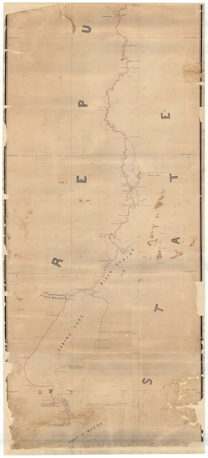
Map of the River Sabine from its mouth on the Gulf of Mexico in the Sea to Logan's Ferry in Latitude 31°58'24" North
K-3-55
-
Map/Doc
87152
-
Collection
General Map Collection
-
Object Dates
[1842 ca.] (Creation Date)
-
People and Organizations
Joint Boundary Commission (Author)
A.B. Gray (Draftsman)
P.J. Pillans (Surveyor/Engineer)
A.B. Gray (Surveyor/Engineer)
G.G. Meade (Surveyor/Engineer)
J.D. Graham (Surveyor/Engineer)
T.J. Lee (Surveyor/Engineer)
-
Subjects
River Surveys Texas Boundaries
-
Height x Width
67.6 x 30.6 inches
171.7 x 77.7 cm
-
Comments
Conservation funded in 2006 by Friends of the Texas General Land Office. Conserved in three pieces. See map 87150 for north part and 87151 for the center part. See map 1744 for the digitally combined image. Texas version of Joint (Boundary) Commission ma
-
URLs
https://medium.com/save-texas-history/map-of-the-river-sabine-e3da735c9925
Related maps
Map of the River Sabine from its mouth on the Gulf of Mexico in the Sea to Logan's Ferry in Latitude 31°58'24" North

Print $40.00
- Digital $50.00
Map of the River Sabine from its mouth on the Gulf of Mexico in the Sea to Logan's Ferry in Latitude 31°58'24" North
1842
Size 173.2 x 31.0 inches
Map/Doc 1744
Journal of the Joint Commission

Print $35.00
- Digital $50.00
Journal of the Joint Commission
1838
Size 9.3 x 6.1 inches
Map/Doc 65515
Map of the River Sabine from its mouth on the Gulf of Mexico in the Sea to Logan's Ferry in Latitude 31°58'24" North

Print $20.00
- Digital $50.00
Map of the River Sabine from its mouth on the Gulf of Mexico in the Sea to Logan's Ferry in Latitude 31°58'24" North
1842
Size 47.9 x 30.6 inches
Map/Doc 87150
Map of the River Sabine from its mouth on the Gulf of Mexico in the Sea to Logan's Ferry in Latitude 31°58'24" North

Print $40.00
- Digital $50.00
Map of the River Sabine from its mouth on the Gulf of Mexico in the Sea to Logan's Ferry in Latitude 31°58'24" North
1842
Size 60.5 x 30.6 inches
Map/Doc 87151
[Map of the River Sabine from its mouth on the Gulf of Mexico in the sea to Logan's Ferry in Latitude 31° 58' 24" North]
![94005, [Map of the River Sabine from its mouth on the Gulf of Mexico in the sea to Logan's Ferry in Latitude 31° 58' 24" North], General Map Collection](https://historictexasmaps.com/wmedia_w700/maps/94005.tif.jpg)
Print $20.00
- Digital $50.00
[Map of the River Sabine from its mouth on the Gulf of Mexico in the sea to Logan's Ferry in Latitude 31° 58' 24" North]
Size 31.5 x 31.3 inches
Map/Doc 94005
[Map of the River Sabine from its mouth on the Gulf of Mexico in the sea to Logan's Ferry in Latitude 31° 58' 24" North]
![94006, [Map of the River Sabine from its mouth on the Gulf of Mexico in the sea to Logan's Ferry in Latitude 31° 58' 24" North], General Map Collection](https://historictexasmaps.com/wmedia_w700/maps/94006.tif.jpg)
Print $20.00
- Digital $50.00
[Map of the River Sabine from its mouth on the Gulf of Mexico in the sea to Logan's Ferry in Latitude 31° 58' 24" North]
Size 37.7 x 31.6 inches
Map/Doc 94006
Part of: General Map Collection
Map of San Patricio County

Print $20.00
- Digital $50.00
Map of San Patricio County
1883
Size 17.2 x 26.8 inches
Map/Doc 4017
Comanche County Working Sketch 18

Print $20.00
- Digital $50.00
Comanche County Working Sketch 18
1973
Size 18.3 x 25.2 inches
Map/Doc 68152
Kinney County Rolled Sketch 19

Print $20.00
- Digital $50.00
Kinney County Rolled Sketch 19
1978
Size 20.7 x 16.8 inches
Map/Doc 6546
Atascosa County Sketch File 2b

Print $6.00
- Digital $50.00
Atascosa County Sketch File 2b
1855
Size 8.8 x 13.2 inches
Map/Doc 13728
Boundary Between the United States & Mexico Agreed Upon by the Joint Commission under the Treaty of Guadalupe Hidalgo

Print $20.00
- Digital $50.00
Boundary Between the United States & Mexico Agreed Upon by the Joint Commission under the Treaty of Guadalupe Hidalgo
1853
Size 24.2 x 18.4 inches
Map/Doc 65397
West Part of Liberty Co.

Print $20.00
- Digital $50.00
West Part of Liberty Co.
1977
Size 43.5 x 32.9 inches
Map/Doc 77353
Andrews County

Print $20.00
- Digital $50.00
Andrews County
1895
Size 24.9 x 26.4 inches
Map/Doc 3231
Kerr County Working Sketch 10

Print $20.00
- Digital $50.00
Kerr County Working Sketch 10
1951
Size 22.3 x 16.0 inches
Map/Doc 70041
Zavala County Working Sketch 28

Print $20.00
- Digital $50.00
Zavala County Working Sketch 28
1994
Size 34.0 x 43.5 inches
Map/Doc 62103
Real County Working Sketch 72

Print $20.00
- Digital $50.00
Real County Working Sketch 72
1976
Size 47.3 x 43.3 inches
Map/Doc 71964
Concho, San Saba & Llano Valley Railway, Sterling City Branch, Texas. Right of Way and Track Map

Print $40.00
- Digital $50.00
Concho, San Saba & Llano Valley Railway, Sterling City Branch, Texas. Right of Way and Track Map
1910
Size 17.9 x 120.8 inches
Map/Doc 64436
Edwards County Working Sketch 30

Print $20.00
- Digital $50.00
Edwards County Working Sketch 30
1947
Size 27.7 x 38.2 inches
Map/Doc 68906
You may also like
Freestone County Sketch File 15

Print $4.00
- Digital $50.00
Freestone County Sketch File 15
Size 6.3 x 8.2 inches
Map/Doc 23070
Aransas County Sketch File 38

Print $244.00
- Digital $50.00
Aransas County Sketch File 38
1996
Size 11.1 x 8.7 inches
Map/Doc 13465
[Worksheets related to the Wilson Strickland survey and vicinity]
![91391, [Worksheets related to the Wilson Strickland survey and vicinity], Twichell Survey Records](https://historictexasmaps.com/wmedia_w700/maps/91391-1.tif.jpg)
Print $20.00
- Digital $50.00
[Worksheets related to the Wilson Strickland survey and vicinity]
Size 42.8 x 19.6 inches
Map/Doc 91391
Pecos County Working Sketch Graphic index - northwest part - sheet A

Print $20.00
- Digital $50.00
Pecos County Working Sketch Graphic index - northwest part - sheet A
1975
Size 42.2 x 42.6 inches
Map/Doc 76663
Cochran County

Print $20.00
- Digital $50.00
Cochran County
1899
Size 41.1 x 34.1 inches
Map/Doc 66755
Presidio County Working Sketch 46

Print $40.00
- Digital $50.00
Presidio County Working Sketch 46
1947
Size 36.8 x 59.0 inches
Map/Doc 71723
Photostat of section of hydrographic surveys H-5399, H-4822, H-470

Print $20.00
- Digital $50.00
Photostat of section of hydrographic surveys H-5399, H-4822, H-470
1933
Size 18.4 x 25.8 inches
Map/Doc 61160
Lampasas County Boundary File 4

Print $44.00
- Digital $50.00
Lampasas County Boundary File 4
Size 14.0 x 8.5 inches
Map/Doc 56110
Hardin County Sketch File 32a

Print $11.00
- Digital $50.00
Hardin County Sketch File 32a
Size 8.4 x 9.8 inches
Map/Doc 25167
Presidio County Sketch File 49

Print $6.00
- Digital $50.00
Presidio County Sketch File 49
1919
Size 14.6 x 11.9 inches
Map/Doc 34584

Reagan County Boundary File 1b

Print $38.00
- Digital $50.00
Reagan County Boundary File 1b
Size 9.3 x 8.3 inches
Map/Doc 58161