Fort Bend County Sketch File 32
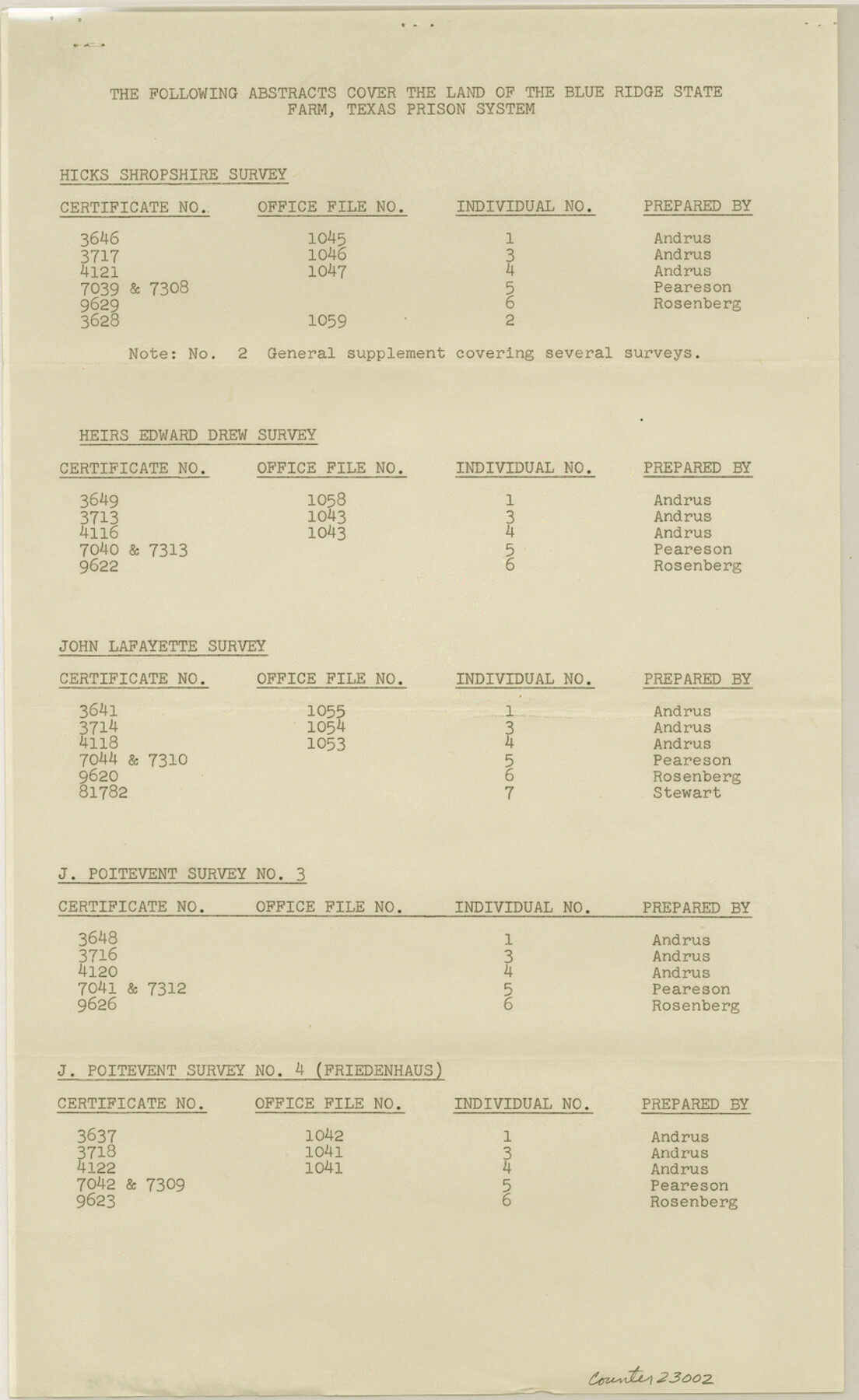
[List of abstracts covering the land of the Blue Ridge State Farm, Texas Prison system]
-
Map/Doc
23002
-
Collection
General Map Collection
-
Object Dates
1957/1/16 (Creation Date)
1957/1/16 (File Date)
-
Counties
Fort Bend
-
Subjects
Surveying Sketch File
-
Height x Width
14.2 x 8.7 inches
36.1 x 22.1 cm
-
Medium
paper, print
-
Features
Blue Ridge State Farm Prison
Part of: General Map Collection
Red River County Sketch File 7

Print $6.00
- Digital $50.00
Red River County Sketch File 7
1855
Size 12.7 x 8.0 inches
Map/Doc 35109
San Patricio County

Print $40.00
- Digital $50.00
San Patricio County
1939
Size 39.3 x 48.3 inches
Map/Doc 73283
Webb County Rolled Sketch 58

Print $40.00
- Digital $50.00
Webb County Rolled Sketch 58
1946
Size 36.7 x 53.4 inches
Map/Doc 10127
Panola County Sketch File 25

Print $20.00
- Digital $50.00
Panola County Sketch File 25
1946
Size 24.1 x 21.4 inches
Map/Doc 12140
Matagorda Bay Including Lavaca and Tres Palacios Bays

Print $40.00
- Digital $50.00
Matagorda Bay Including Lavaca and Tres Palacios Bays
1973
Size 37.0 x 48.4 inches
Map/Doc 73363
Wichita County Sketch File 13a

Print $6.00
- Digital $50.00
Wichita County Sketch File 13a
1881
Size 9.4 x 6.0 inches
Map/Doc 40084
Map of the United States engraved to illustrate Mitchell's new intermediate geography

Print $20.00
- Digital $50.00
Map of the United States engraved to illustrate Mitchell's new intermediate geography
1885
Size 12.2 x 18.5 inches
Map/Doc 93514
Hamilton County Sketch File 24

Print $20.00
- Digital $50.00
Hamilton County Sketch File 24
1953
Size 23.2 x 22.8 inches
Map/Doc 11619

Bandera County Rolled Sketch 5

Print $20.00
- Digital $50.00
Bandera County Rolled Sketch 5
1973
Size 19.8 x 31.0 inches
Map/Doc 5117
Presidio County Sketch File 52

Print $10.00
- Digital $50.00
Presidio County Sketch File 52
1921
Size 11.5 x 8.8 inches
Map/Doc 34605
Hood County Sketch File 7

Print $6.00
- Digital $50.00
Hood County Sketch File 7
Size 12.9 x 7.9 inches
Map/Doc 26581
You may also like
Orange County Rolled Sketch 20

Print $40.00
- Digital $50.00
Orange County Rolled Sketch 20
1947
Size 35.2 x 64.3 inches
Map/Doc 9645
Presidio County Working Sketch 144

Print $20.00
- Digital $50.00
Presidio County Working Sketch 144
1990
Size 20.4 x 26.6 inches
Map/Doc 71822
Bexar County Working Sketch 8

Print $20.00
- Digital $50.00
Bexar County Working Sketch 8
1954
Size 26.8 x 25.2 inches
Map/Doc 67324
Map of Throckmorton County Young Land District

Print $20.00
- Digital $50.00
Map of Throckmorton County Young Land District
1859
Size 25.2 x 20.3 inches
Map/Doc 4078
Donley County Boundary File 9

Print $50.00
- Digital $50.00
Donley County Boundary File 9
1903
Size 13.0 x 8.1 inches
Map/Doc 62233
Pecos County Rolled Sketch 190

Print $20.00
- Digital $50.00
Pecos County Rolled Sketch 190
2005
Size 20.3 x 26.1 inches
Map/Doc 83284
Haskell County Boundary File 7

Print $40.00
- Digital $50.00
Haskell County Boundary File 7
Size 3.6 x 38.5 inches
Map/Doc 54584
Bird's Eye View of the City of Gainesville Cooke County, Texas

Print $20.00
Bird's Eye View of the City of Gainesville Cooke County, Texas
1883
Size 19.2 x 25.6 inches
Map/Doc 89084
Val Verde County Rolled Sketch 52

Print $20.00
- Digital $50.00
Val Verde County Rolled Sketch 52
1937
Size 31.8 x 23.0 inches
Map/Doc 8121
Flight Mission No. BRA-17M, Frame 7, Jefferson County

Print $20.00
- Digital $50.00
Flight Mission No. BRA-17M, Frame 7, Jefferson County
1953
Size 18.7 x 22.3 inches
Map/Doc 85788
Eastland County Working Sketch 45

Print $20.00
- Digital $50.00
Eastland County Working Sketch 45
1979
Size 31.3 x 43.7 inches
Map/Doc 68826
Cooke County Rolled Sketch 4

Print $20.00
- Digital $50.00
Cooke County Rolled Sketch 4
Size 18.1 x 23.1 inches
Map/Doc 5562