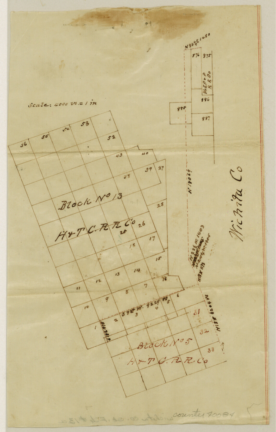
Wichita County Sketch File 13a
[Plat and field notes of connecting line from the east boundary line of survey 33, Block 5, H. & T. C. R.R. Co. in Wichita County to the northwest corner of survey 875 on the Red River in Wilbarger County]
-
Map/Doc
40084
-
Collection
General Map Collection
-
Object Dates
12/15/1881 (Creation Date)
1/20/1882 (File Date)
-
People and Organizations
George Raines (Chainman/Field Personnel)
David Campbell (Chainman/Field Personnel)
C.B. Patterson (Surveyor/Engineer)
-
Counties
Wichita Wilbarger
-
Subjects
Surveying Sketch File
-
Height x Width
9.4 x 6.0 inches
23.9 x 15.2 cm
-
Medium
paper, manuscript
Part of: General Map Collection
Bastrop County Working Sketch 3

Print $20.00
- Digital $50.00
Bastrop County Working Sketch 3
1921
Size 22.9 x 15.4 inches
Map/Doc 67303
Map of Runnels County

Print $20.00
- Digital $50.00
Map of Runnels County
1858
Size 24.7 x 25.6 inches
Map/Doc 4004
Starr County Sketch File 30A

Print $20.00
- Digital $50.00
Starr County Sketch File 30A
1935
Size 21.2 x 23.6 inches
Map/Doc 12334
Texas Gulf Coast, from the Sabine River to the Rio Grande as Subdivided for Mineral Development; Galveston, Brazoria and Matagorda Counties

Print $40.00
- Digital $50.00
Texas Gulf Coast, from the Sabine River to the Rio Grande as Subdivided for Mineral Development; Galveston, Brazoria and Matagorda Counties
1976
Size 43.8 x 69.3 inches
Map/Doc 1938
San Augustine County Sketch File 1

Print $4.00
San Augustine County Sketch File 1
1849
Size 9.3 x 8.2 inches
Map/Doc 35631
Brewster County Rolled Sketch 110

Print $20.00
- Digital $50.00
Brewster County Rolled Sketch 110
1961
Size 19.7 x 37.7 inches
Map/Doc 5262
Webb County Rolled Sketch 42

Print $20.00
- Digital $50.00
Webb County Rolled Sketch 42
1941
Size 25.2 x 37.1 inches
Map/Doc 8197
Concho County Sketch File 10

Print $20.00
- Digital $50.00
Concho County Sketch File 10
1887
Size 23.1 x 33.8 inches
Map/Doc 11150
Travis County Sketch File 60

Print $20.00
- Digital $50.00
Travis County Sketch File 60
1945
Size 23.0 x 15.9 inches
Map/Doc 12472
Map of the country adjacent to the left bank of the Rio Grande below Matamoros

Print $20.00
- Digital $50.00
Map of the country adjacent to the left bank of the Rio Grande below Matamoros
1847
Size 18.4 x 27.4 inches
Map/Doc 72869
Ochiltree County

Print $20.00
- Digital $50.00
Ochiltree County
1889
Size 23.1 x 19.5 inches
Map/Doc 3923
Flight Mission No. DCL-4C, Frame 69, Kenedy County

Print $20.00
- Digital $50.00
Flight Mission No. DCL-4C, Frame 69, Kenedy County
1943
Size 18.7 x 22.3 inches
Map/Doc 85814
You may also like
[T. & P. Surveys in Crane, Upton, Coke Counties]
![90464, [T. & P. Surveys in Crane, Upton, Coke Counties], Twichell Survey Records](https://historictexasmaps.com/wmedia_w700/maps/90464-1.tif.jpg)
Print $20.00
- Digital $50.00
[T. & P. Surveys in Crane, Upton, Coke Counties]
Size 19.2 x 21.2 inches
Map/Doc 90464

General Highway Map, Medina County, Texas

Print $20.00
General Highway Map, Medina County, Texas
1961
Size 18.2 x 25.0 inches
Map/Doc 79594
Dickens County Working Sketch 11

Print $40.00
- Digital $50.00
Dickens County Working Sketch 11
1969
Size 52.6 x 37.8 inches
Map/Doc 68659
Andrews County Working Sketch 2

Print $20.00
- Digital $50.00
Andrews County Working Sketch 2
1949
Size 23.2 x 23.7 inches
Map/Doc 67048
Flight Mission No. BRE-1P, Frame 81, Nueces County

Print $20.00
- Digital $50.00
Flight Mission No. BRE-1P, Frame 81, Nueces County
1956
Size 18.3 x 22.1 inches
Map/Doc 86663
Potter County

Print $20.00
- Digital $50.00
Potter County
1909
Size 47.5 x 40.8 inches
Map/Doc 66984
Atascosa County Rolled Sketch 22

Print $40.00
- Digital $50.00
Atascosa County Rolled Sketch 22
1917
Size 26.3 x 57.2 inches
Map/Doc 8434
The Republic County of Robertson. January 30, 1841

Print $20.00
The Republic County of Robertson. January 30, 1841
2020
Size 16.9 x 21.7 inches
Map/Doc 96261
Yoakum County Sketch File 9

Print $20.00
- Digital $50.00
Yoakum County Sketch File 9
Size 14.1 x 8.9 inches
Map/Doc 40753
Martin County Working Sketch 6

Print $20.00
- Digital $50.00
Martin County Working Sketch 6
1971
Size 41.8 x 36.9 inches
Map/Doc 70824
Val Verde County Working Sketch 90

Print $40.00
- Digital $50.00
Val Verde County Working Sketch 90
1974
Size 49.1 x 32.9 inches
Map/Doc 72225