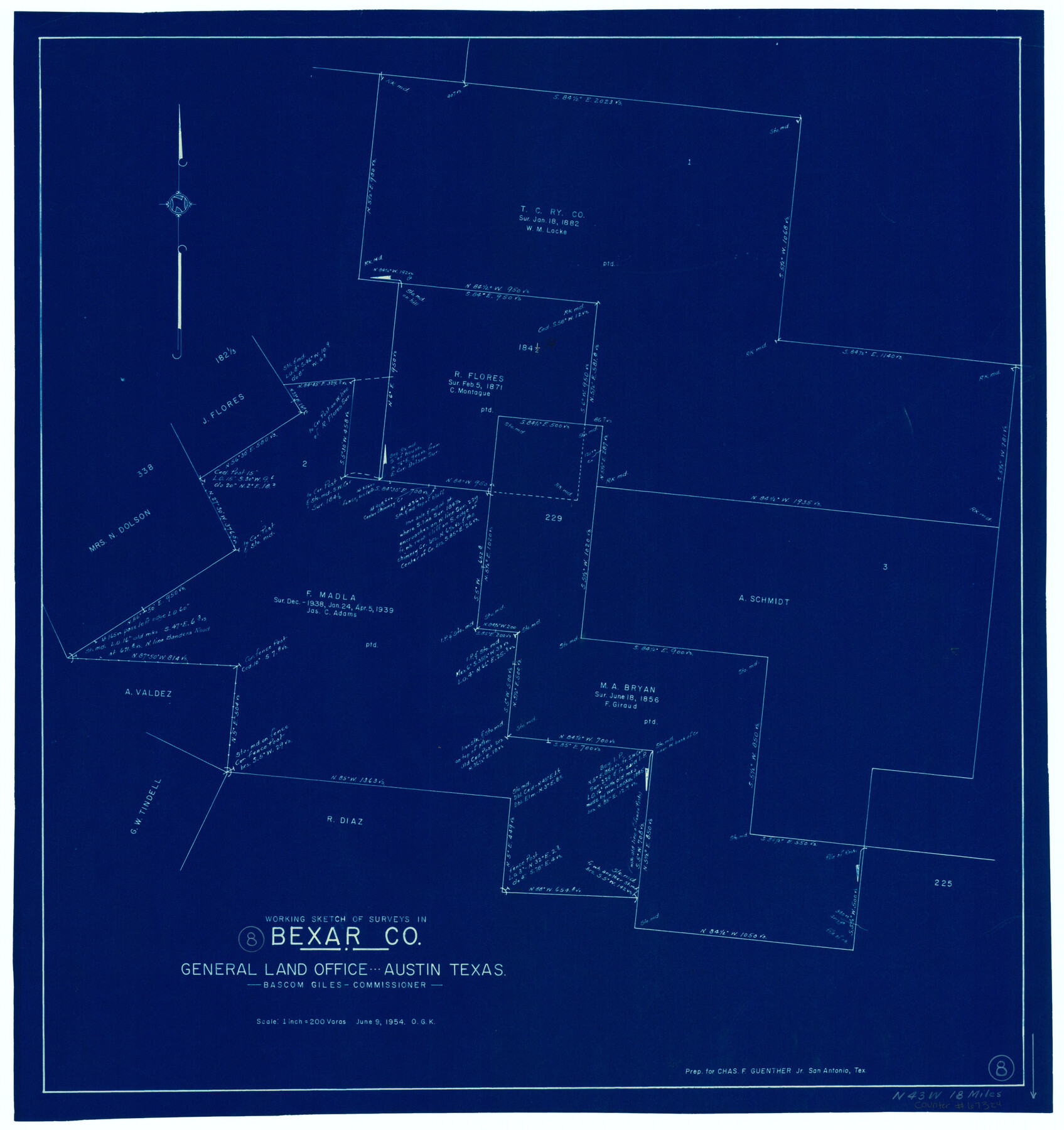
Bexar County Working Sketch 8
-
Map/Doc
67324
-
Collection
General Map Collection
-
Object Dates
6/9/1954 (Creation Date)
-
People and Organizations
Bascom Giles (GLO Commissioner)
Otto G. Kurio (Draftsman)
-
Counties
Bexar
-
Subjects
Surveying Working Sketch
-
Height x Width
26.8 x 25.2 inches
68.1 x 64.0 cm
-
Scale
1" = 200 varas
-
Comments
Surveys located about 18 miles North 43 degrees West of San Antonio, Texas.
Part of: General Map Collection
Navarro County Working Sketch 2

Print $20.00
- Digital $50.00
Navarro County Working Sketch 2
1922
Size 21.9 x 22.2 inches
Map/Doc 71232
Crockett County Sketch File D

Print $40.00
- Digital $50.00
Crockett County Sketch File D
1903
Size 24.6 x 48.0 inches
Map/Doc 10347
Edwards County Sketch File 35a

Print $20.00
- Digital $50.00
Edwards County Sketch File 35a
1928
Size 33.0 x 23.5 inches
Map/Doc 11435
Ector County Rolled Sketch 9

Print $20.00
- Digital $50.00
Ector County Rolled Sketch 9
1940
Size 39.1 x 43.0 inches
Map/Doc 8837
Map of Brassos [sic] & Bosque Surveys
![146, Map of Brassos [sic] & Bosque Surveys, General Map Collection](https://historictexasmaps.com/wmedia_w700/maps/146.tif.jpg)
Print $20.00
- Digital $50.00
Map of Brassos [sic] & Bosque Surveys
1841
Size 27.7 x 18.9 inches
Map/Doc 146
A New Map of Texas with the contiguous American and Mexican States

Print $20.00
- Digital $50.00
A New Map of Texas with the contiguous American and Mexican States
1839
Size 13.0 x 15.4 inches
Map/Doc 96513
Flight Mission No. CGI-4N, Frame 182, Cameron County

Print $20.00
- Digital $50.00
Flight Mission No. CGI-4N, Frame 182, Cameron County
1955
Size 18.4 x 22.2 inches
Map/Doc 84685
Jasper County

Print $20.00
- Digital $50.00
Jasper County
1946
Size 46.8 x 41.0 inches
Map/Doc 77325
Tarrant County

Print $40.00
- Digital $50.00
Tarrant County
1942
Size 48.6 x 37.8 inches
Map/Doc 73298
Callahan County Working Sketch 4

Print $20.00
- Digital $50.00
Callahan County Working Sketch 4
1953
Size 17.1 x 27.0 inches
Map/Doc 67886
Maps of Gulf Intracoastal Waterway, Texas - Sabine River to the Rio Grande and connecting waterways including ship channels

Print $20.00
- Digital $50.00
Maps of Gulf Intracoastal Waterway, Texas - Sabine River to the Rio Grande and connecting waterways including ship channels
1966
Size 14.6 x 22.3 inches
Map/Doc 61954
Jeff Davis County Sketch File 7

Print $30.00
- Digital $50.00
Jeff Davis County Sketch File 7
1879
Size 12.8 x 8.1 inches
Map/Doc 27905
You may also like
[Fractional Township No. 7 South Range No. 17 East of the Indian Meridian, Indian Territory]
![75231, [Fractional Township No. 7 South Range No. 17 East of the Indian Meridian, Indian Territory], General Map Collection](https://historictexasmaps.com/wmedia_w700/maps/75231.tif.jpg)
Print $20.00
- Digital $50.00
[Fractional Township No. 7 South Range No. 17 East of the Indian Meridian, Indian Territory]
Size 19.2 x 24.3 inches
Map/Doc 75231
Flight Mission No. DIX-8P, Frame 73, Aransas County

Print $20.00
- Digital $50.00
Flight Mission No. DIX-8P, Frame 73, Aransas County
1956
Size 18.7 x 22.3 inches
Map/Doc 83904
Flight Mission No. DIX-7P, Frame 14, Aransas County

Print $20.00
- Digital $50.00
Flight Mission No. DIX-7P, Frame 14, Aransas County
1956
Size 18.8 x 22.6 inches
Map/Doc 83866
Matagorda County Working Sketch 26

Print $20.00
- Digital $50.00
Matagorda County Working Sketch 26
1979
Size 14.1 x 19.5 inches
Map/Doc 70884
Railroad Track Map, H&TCRRCo., Falls County, Texas

Print $4.00
- Digital $50.00
Railroad Track Map, H&TCRRCo., Falls County, Texas
1918
Size 11.8 x 18.4 inches
Map/Doc 62838
Panola County Sketch File 11

Print $6.00
- Digital $50.00
Panola County Sketch File 11
1872
Size 10.3 x 13.2 inches
Map/Doc 33467
[Sketch for Mineral Application 27670 - Strip between Simon Sanchez leagues and Trinity River]
![2862, [Sketch for Mineral Application 27670 - Strip between Simon Sanchez leagues and Trinity River], General Map Collection](https://historictexasmaps.com/wmedia_w700/maps/2862-1.tif.jpg)
Print $20.00
- Digital $50.00
[Sketch for Mineral Application 27670 - Strip between Simon Sanchez leagues and Trinity River]
1934
Size 25.7 x 39.9 inches
Map/Doc 2862
McLennan County Sketch File 2

Print $6.00
- Digital $50.00
McLennan County Sketch File 2
1856
Size 11.5 x 7.7 inches
Map/Doc 31230
[Sketch for Mineral Application 27670 - Strip between Simon Sanchez leagues and Trinity River]
![2865, [Sketch for Mineral Application 27670 - Strip between Simon Sanchez leagues and Trinity River], General Map Collection](https://historictexasmaps.com/wmedia_w700/maps/2865-1.tif.jpg)
Print $40.00
- Digital $50.00
[Sketch for Mineral Application 27670 - Strip between Simon Sanchez leagues and Trinity River]
1934
Size 17.3 x 50.5 inches
Map/Doc 2865
PSL Field Notes for Blocks A19, A20, A22, A23, A26, A28, A29, A30, A31, A32, A33, A34, A35, A36, A37, A38, A39, A40, A41 in Andrews County

PSL Field Notes for Blocks A19, A20, A22, A23, A26, A28, A29, A30, A31, A32, A33, A34, A35, A36, A37, A38, A39, A40, A41 in Andrews County
Map/Doc 81642
[H. & G. N. RR. Company, Block 1 and Vicinity]
![91232, [H. & G. N. RR. Company, Block 1 and Vicinity], Twichell Survey Records](https://historictexasmaps.com/wmedia_w700/maps/91232-1.tif.jpg)
Print $20.00
- Digital $50.00
[H. & G. N. RR. Company, Block 1 and Vicinity]
Size 14.1 x 17.7 inches
Map/Doc 91232
Navigation Maps of Gulf Intracoastal Waterway, Port Arthur to Brownsville, Texas

Print $4.00
- Digital $50.00
Navigation Maps of Gulf Intracoastal Waterway, Port Arthur to Brownsville, Texas
1951
Size 16.6 x 21.5 inches
Map/Doc 65427