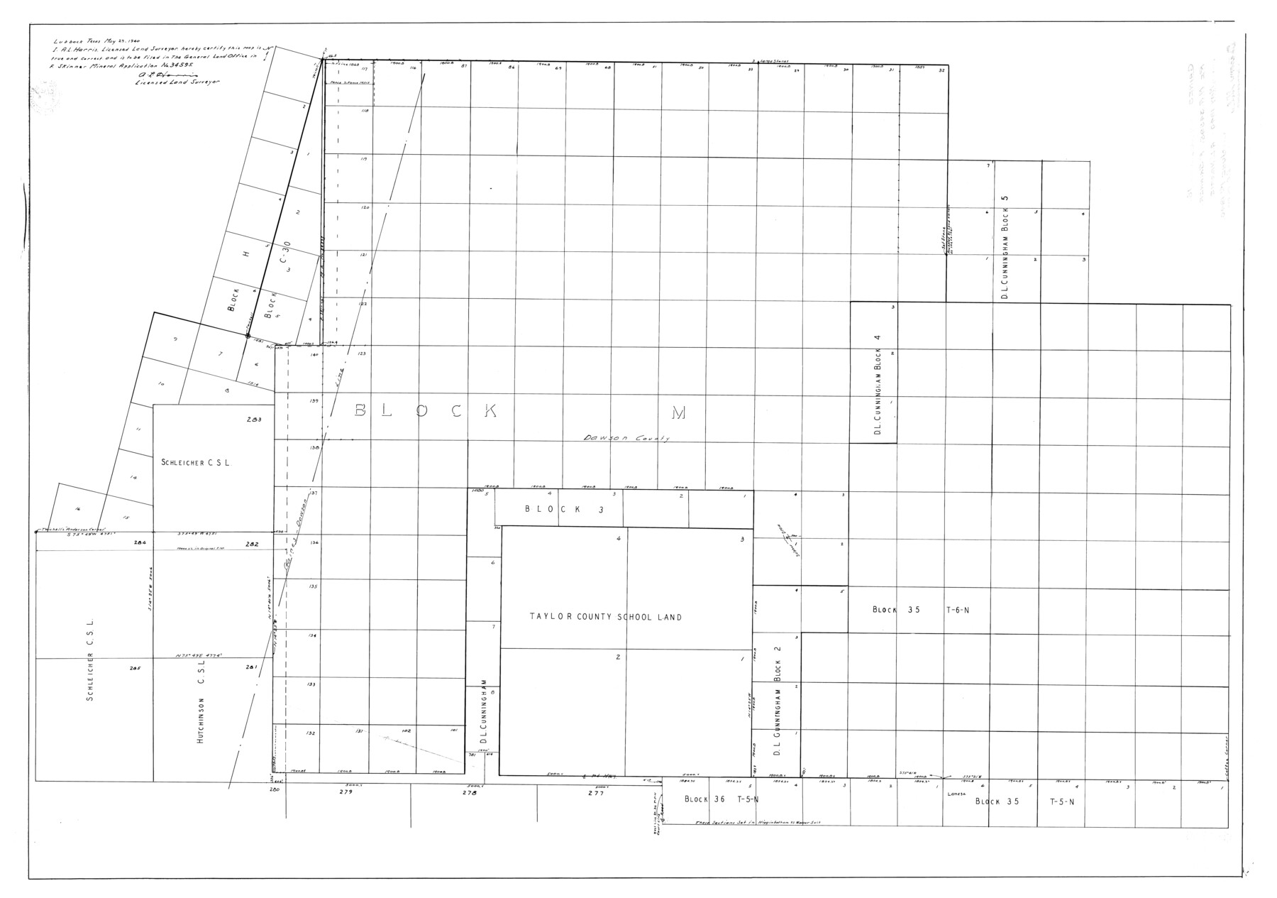
Gaines County Rolled Sketch 16
[Sketch on Gaines-Dawson county line re: MA 34595 F. Skinner]
-
Map/Doc
9039
-
Collection
General Map Collection
-
Object Dates
1940 (Creation Date)
1940/6/1 (File Date)
-
People and Organizations
A.L. Harris (Surveyor/Engineer)
-
Counties
Gaines Dawson
-
Subjects
Surveying Rolled Sketch
-
Height x Width
51.2 x 36.0 inches
130.0 x 91.4 cm
Part of: General Map Collection

Johnson County Sketch File 10a

Print $4.00
- Digital $50.00
Johnson County Sketch File 10a
1877
Size 6.7 x 10.6 inches
Map/Doc 28445
Reagan County Working Sketch 35

Print $40.00
- Digital $50.00
Reagan County Working Sketch 35
1966
Size 29.7 x 51.4 inches
Map/Doc 71877
Kimble County Rolled Sketch 17 1/2

Print $59.00
- Digital $50.00
Kimble County Rolled Sketch 17 1/2
1889
Size 27.0 x 38.3 inches
Map/Doc 6510
Duval County Sketch File 20 1/2

Print $4.00
- Digital $50.00
Duval County Sketch File 20 1/2
1880
Size 10.3 x 8.4 inches
Map/Doc 21324
Notes for map of Montgomery County

Print $20.00
- Digital $50.00
Notes for map of Montgomery County
1844
Size 17.6 x 21.9 inches
Map/Doc 78370
Henderson County Working Sketch 22

Print $20.00
- Digital $50.00
Henderson County Working Sketch 22
1951
Size 26.5 x 31.2 inches
Map/Doc 66155

Chambers County NRC Article 33.136 Sketch 14

Print $42.00
- Digital $50.00
Chambers County NRC Article 33.136 Sketch 14
Size 34.5 x 22.6 inches
Map/Doc 97016
Brazoria County Sketch File 49

Print $20.00
- Digital $50.00
Brazoria County Sketch File 49
Size 14.2 x 8.7 inches
Map/Doc 15112
Presidio County Rolled Sketch 36

Print $20.00
- Digital $50.00
Presidio County Rolled Sketch 36
Size 20.7 x 21.8 inches
Map/Doc 7334
Coke County Sketch File 12

Print $8.00
- Digital $50.00
Coke County Sketch File 12
Size 9.4 x 8.0 inches
Map/Doc 18592
You may also like
Amistad International Reservoir on Rio Grande 68a

Print $20.00
- Digital $50.00
Amistad International Reservoir on Rio Grande 68a
1949
Size 28.4 x 39.6 inches
Map/Doc 73354
Mapa de toda la Frontera de los dominios del Rey en la America septentrional

Print $40.00
Mapa de toda la Frontera de los dominios del Rey en la America septentrional
1771
Size 26.4 x 50.0 inches
Map/Doc 95311
Kinney County Rolled Sketch 14

Print $20.00
- Digital $50.00
Kinney County Rolled Sketch 14
1956
Size 19.5 x 25.8 inches
Map/Doc 6543
[E. T. Ry. Blk. 1]
![89797, [E. T. Ry. Blk. 1], Twichell Survey Records](https://historictexasmaps.com/wmedia_w700/maps/89797-1.tif.jpg)
Print $40.00
- Digital $50.00
[E. T. Ry. Blk. 1]
Size 41.8 x 49.9 inches
Map/Doc 89797
La Salle County Sketch File 45

Print $40.00
- Digital $50.00
La Salle County Sketch File 45
1939
Size 16.9 x 14.2 inches
Map/Doc 29601
Outer Continental Shelf Leasing Maps (Texas Offshore Operations)

Print $20.00
- Digital $50.00
Outer Continental Shelf Leasing Maps (Texas Offshore Operations)
Size 12.7 x 15.2 inches
Map/Doc 76169
Brown County Rolled Sketch 1

Print $20.00
- Digital $50.00
Brown County Rolled Sketch 1
1969
Size 15.4 x 22.1 inches
Map/Doc 5348
San Patricio County Sketch File 13

Print $4.00
San Patricio County Sketch File 13
Size 5.9 x 8.5 inches
Map/Doc 36049
Kendall County Working Sketch 16

Print $20.00
- Digital $50.00
Kendall County Working Sketch 16
1967
Size 28.0 x 29.1 inches
Map/Doc 66688
Upton County Working Sketch 39

Print $20.00
- Digital $50.00
Upton County Working Sketch 39
1958
Size 25.4 x 30.1 inches
Map/Doc 69535
Flight Mission No. CLL-1N, Frame 17, Willacy County

Print $20.00
- Digital $50.00
Flight Mission No. CLL-1N, Frame 17, Willacy County
1954
Size 18.5 x 22.1 inches
Map/Doc 87004
Right of Way & Track Map Houston & Brazos Valley Ry. operated by Houston & Brazos Valley Ry. Co., Hoskins Mound Branch

Print $40.00
- Digital $50.00
Right of Way & Track Map Houston & Brazos Valley Ry. operated by Houston & Brazos Valley Ry. Co., Hoskins Mound Branch
1924
Size 25.0 x 56.7 inches
Map/Doc 66713