Falls County Sketch File 13
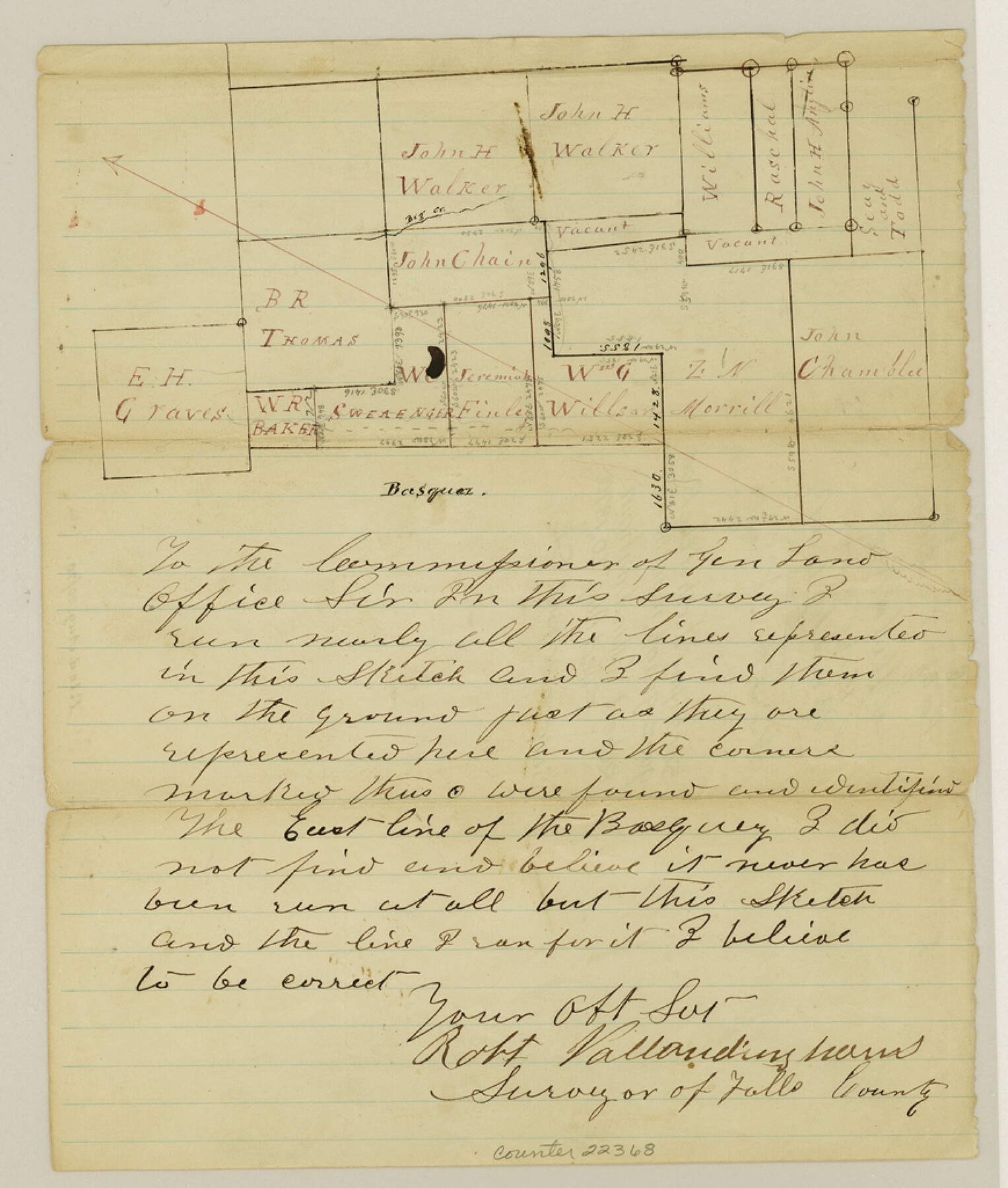
[Sketch of surveys lying north of the Basquez grant, near the northeast corner of county]
-
Map/Doc
22368
-
Collection
General Map Collection
-
Object Dates
1870/8/20 (Creation Date)
1870/8/20 (File Date)
-
People and Organizations
Robert Vallandingham (Surveyor/Engineer)
-
Counties
Falls
-
Subjects
Surveying Sketch File
-
Height x Width
10.3 x 8.7 inches
26.2 x 22.1 cm
-
Medium
paper, manuscript
-
Features
Big Creek
[Brushy Creek]
Part of: General Map Collection
Cottle County Rolled Sketch 14

Print $741.00
- Digital $50.00
Cottle County Rolled Sketch 14
1882
Size 10.8 x 16.0 inches
Map/Doc 42369
Dallam County Sketch File 12

Print $40.00
- Digital $50.00
Dallam County Sketch File 12
Size 50.0 x 9.1 inches
Map/Doc 10360
Montgomery County Working Sketch 45

Print $20.00
- Digital $50.00
Montgomery County Working Sketch 45
1956
Size 14.8 x 29.5 inches
Map/Doc 71152
Flight Mission No. DIX-5P, Frame 110, Aransas County

Print $20.00
- Digital $50.00
Flight Mission No. DIX-5P, Frame 110, Aransas County
1956
Size 17.7 x 18.3 inches
Map/Doc 83789
Webb County Sketch File 50

Print $20.00
- Digital $50.00
Webb County Sketch File 50
1939
Size 27.4 x 18.6 inches
Map/Doc 12648
Flight Mission No. BRA-6M, Frame 80, Jefferson County

Print $20.00
- Digital $50.00
Flight Mission No. BRA-6M, Frame 80, Jefferson County
1953
Size 18.6 x 22.3 inches
Map/Doc 85424
Flight Mission No. DCL-7C, Frame 39, Kenedy County

Print $20.00
- Digital $50.00
Flight Mission No. DCL-7C, Frame 39, Kenedy County
1943
Size 15.3 x 15.3 inches
Map/Doc 86027
Montague County Working Sketch 27

Print $20.00
- Digital $50.00
Montague County Working Sketch 27
1956
Size 35.8 x 24.9 inches
Map/Doc 71093
Harrison County Working Sketch 11

Print $20.00
- Digital $50.00
Harrison County Working Sketch 11
1961
Size 27.8 x 28.0 inches
Map/Doc 66031
Flight Mission No. BQR-14K, Frame 38, Brazoria County

Print $20.00
- Digital $50.00
Flight Mission No. BQR-14K, Frame 38, Brazoria County
1952
Size 18.8 x 22.3 inches
Map/Doc 84095
Flight Mission No. CLL-3N, Frame 18, Willacy County

Print $20.00
- Digital $50.00
Flight Mission No. CLL-3N, Frame 18, Willacy County
1954
Size 18.4 x 22.1 inches
Map/Doc 87084
Tom Green County Sketch File 50

Print $20.00
- Digital $50.00
Tom Green County Sketch File 50
1884
Size 25.4 x 34.5 inches
Map/Doc 12442
You may also like
[Sketch of Survey 9, Block Z3]
![93091, [Sketch of Survey 9, Block Z3], Twichell Survey Records](https://historictexasmaps.com/wmedia_w700/maps/93091-1.tif.jpg)
Print $2.00
- Digital $50.00
[Sketch of Survey 9, Block Z3]
Size 7.0 x 6.9 inches
Map/Doc 93091
Cochran County Rolled Sketch 2

Print $20.00
- Digital $50.00
Cochran County Rolled Sketch 2
1940
Size 27.7 x 33.9 inches
Map/Doc 5500

Presidio County Working Sketch 33

Print $40.00
- Digital $50.00
Presidio County Working Sketch 33
1947
Size 41.6 x 50.6 inches
Map/Doc 71710
Flight Mission No. DQO-2K, Frame 161, Galveston County

Print $20.00
- Digital $50.00
Flight Mission No. DQO-2K, Frame 161, Galveston County
1952
Size 18.7 x 22.4 inches
Map/Doc 85050
Montgomery County

Print $20.00
- Digital $50.00
Montgomery County
1871
Size 21.0 x 24.6 inches
Map/Doc 3891
Flight Mission No. DAH-9M, Frame 197, Orange County

Print $20.00
- Digital $50.00
Flight Mission No. DAH-9M, Frame 197, Orange County
1953
Size 18.5 x 22.4 inches
Map/Doc 86865
Dawson County Working Sketch 2

Print $20.00
- Digital $50.00
Dawson County Working Sketch 2
1937
Size 8.8 x 20.3 inches
Map/Doc 68546
Brewster County Working Sketch 53

Print $20.00
- Digital $50.00
Brewster County Working Sketch 53
1951
Size 32.1 x 16.5 inches
Map/Doc 67587
Shackelford County

Print $20.00
- Digital $50.00
Shackelford County
1920
Size 44.6 x 37.1 inches
Map/Doc 16813

Harris County Sketch File 1b

Print $3.00
- Digital $50.00
Harris County Sketch File 1b
Size 15.3 x 10.4 inches
Map/Doc 25330