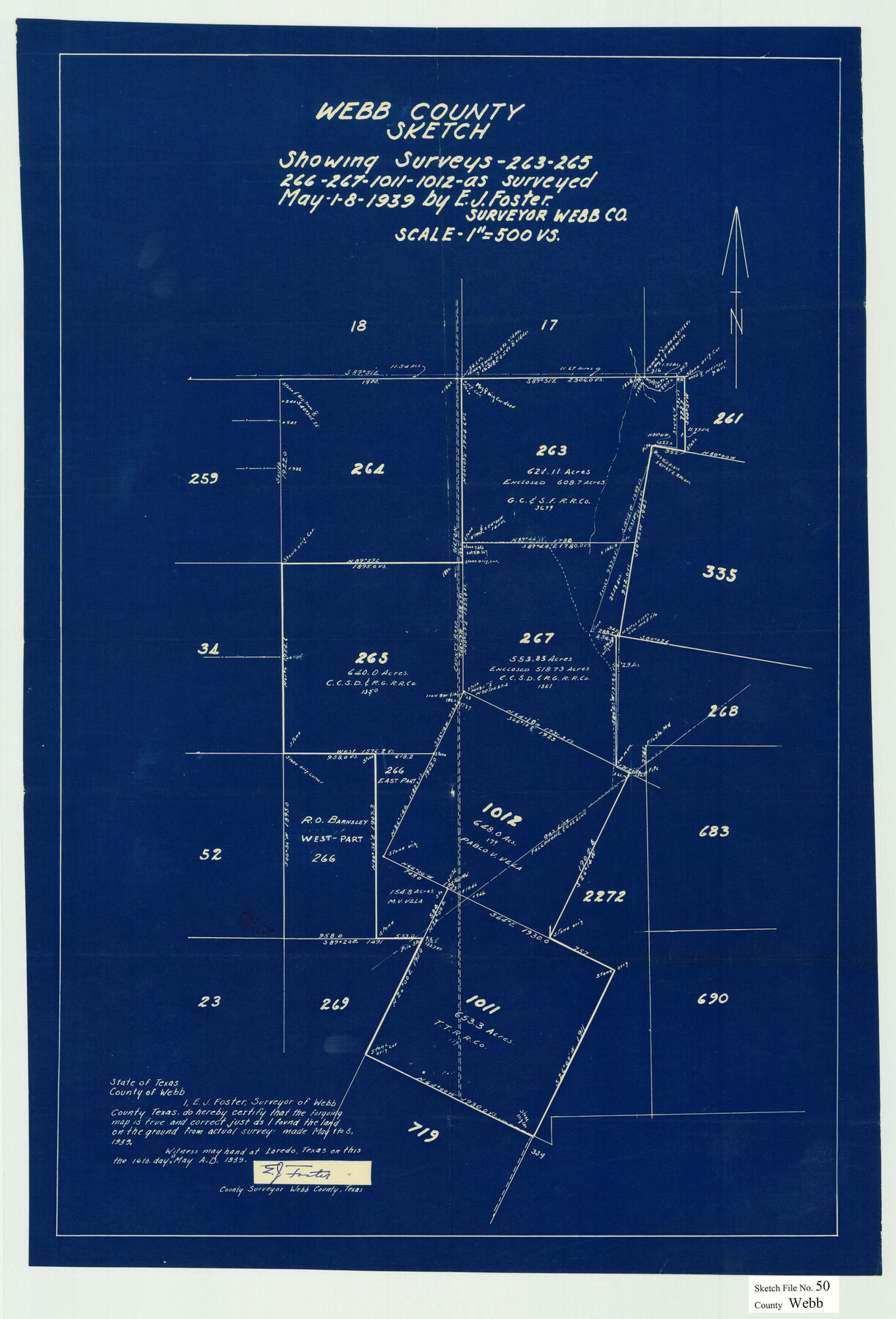
Webb County Sketch File 50
Webb County sketch showing surveys 263, 265, 266, 267, 1011, 1012 northeast from Laredo
-
Map/Doc
12648
-
Collection
General Map Collection
-
Object Dates
5/16/1939 (Creation Date)
5/26/1939 (File Date)
5/1-8/1939 (Survey Date)
-
People and Organizations
E.J. Foster (Surveyor/Engineer)
-
Counties
Webb
-
Subjects
Surveying Sketch File
-
Height x Width
27.4 x 18.6 inches
69.6 x 47.2 cm
-
Medium
blueprint/diazo
-
Scale
1" = 500 varas
Part of: General Map Collection
Packery Channel

Print $3.00
- Digital $50.00
Packery Channel
1974
Size 10.2 x 10.3 inches
Map/Doc 3000
Colorado County Working Sketch 23

Print $20.00
- Digital $50.00
Colorado County Working Sketch 23
1967
Size 38.0 x 32.9 inches
Map/Doc 68123
Flight Mission No. CGI-3N, Frame 97, Cameron County

Print $20.00
- Digital $50.00
Flight Mission No. CGI-3N, Frame 97, Cameron County
1954
Size 18.6 x 22.1 inches
Map/Doc 84577
Hidalgo County Sketch File 19

Print $42.00
- Digital $50.00
Hidalgo County Sketch File 19
1983
Size 11.3 x 8.9 inches
Map/Doc 26448
Val Verde County Sketch File 51b

Print $6.00
- Digital $50.00
Val Verde County Sketch File 51b
Size 10.1 x 8.8 inches
Map/Doc 39329
Navarro County Working Sketch 18

Print $20.00
- Digital $50.00
Navarro County Working Sketch 18
2009
Size 31.9 x 38.0 inches
Map/Doc 89044
Baylor County Sketch File 26

Print $22.00
- Digital $50.00
Baylor County Sketch File 26
Size 14.6 x 9.0 inches
Map/Doc 14215
Montague County Working Sketch 24

Print $20.00
- Digital $50.00
Montague County Working Sketch 24
1953
Size 21.9 x 27.6 inches
Map/Doc 71090
Hudspeth County Sketch File 29

Print $20.00
- Digital $50.00
Hudspeth County Sketch File 29
1918
Size 22.3 x 21.4 inches
Map/Doc 11804
Kaufman County

Print $40.00
- Digital $50.00
Kaufman County
1942
Size 50.0 x 41.0 inches
Map/Doc 95552
Gregg County Rolled Sketch 12

Print $40.00
- Digital $50.00
Gregg County Rolled Sketch 12
1939
Size 49.5 x 55.5 inches
Map/Doc 9065
New Map of the State of Texas Compiled from J. De Cordova's large Map
Print $20.00
- Digital $50.00
New Map of the State of Texas Compiled from J. De Cordova's large Map
Size 17.8 x 27.4 inches
Map/Doc 89253
You may also like
Somervell County Sketch File 1

Print $4.00
- Digital $50.00
Somervell County Sketch File 1
1859
Size 12.8 x 8.1 inches
Map/Doc 36795
Brazoria County NRC Article 33.136 Sketch 4

Print $22.00
- Digital $50.00
Brazoria County NRC Article 33.136 Sketch 4
2003
Size 24.3 x 35.8 inches
Map/Doc 80120
Flight Mission No. DAG-24K, Frame 36, Matagorda County

Print $20.00
- Digital $50.00
Flight Mission No. DAG-24K, Frame 36, Matagorda County
1953
Size 18.5 x 22.2 inches
Map/Doc 86523
Hays County Sketch File C

Print $40.00
- Digital $50.00
Hays County Sketch File C
Size 17.9 x 14.6 inches
Map/Doc 26197
Midland County Rolled Sketch 12

Print $40.00
- Digital $50.00
Midland County Rolled Sketch 12
Size 97.0 x 42.6 inches
Map/Doc 9520
Flight Mission No. CGN-3P, Frame 22, San Patricio County

Print $20.00
- Digital $50.00
Flight Mission No. CGN-3P, Frame 22, San Patricio County
1956
Size 18.6 x 22.3 inches
Map/Doc 86980
Archer County Sketch File 24

Print $40.00
- Digital $50.00
Archer County Sketch File 24
1924
Size 31.7 x 25.0 inches
Map/Doc 10832
Flight Mission No. BRA-7M, Frame 196, Jefferson County

Print $20.00
- Digital $50.00
Flight Mission No. BRA-7M, Frame 196, Jefferson County
1953
Size 18.5 x 22.3 inches
Map/Doc 85564
Galveston County NRC Article 33.136 Sketch 93

Digital $50.00
Galveston County NRC Article 33.136 Sketch 93
2020
Map/Doc 97257
Jack County Working Sketch 6

Print $20.00
- Digital $50.00
Jack County Working Sketch 6
1952
Size 29.1 x 24.3 inches
Map/Doc 66432
Bastrop County

Print $40.00
- Digital $50.00
Bastrop County
1917
Size 48.0 x 40.5 inches
Map/Doc 4881
Ochiltree County Rolled Sketch 2

Print $20.00
- Digital $50.00
Ochiltree County Rolled Sketch 2
Size 23.0 x 17.7 inches
Map/Doc 7172