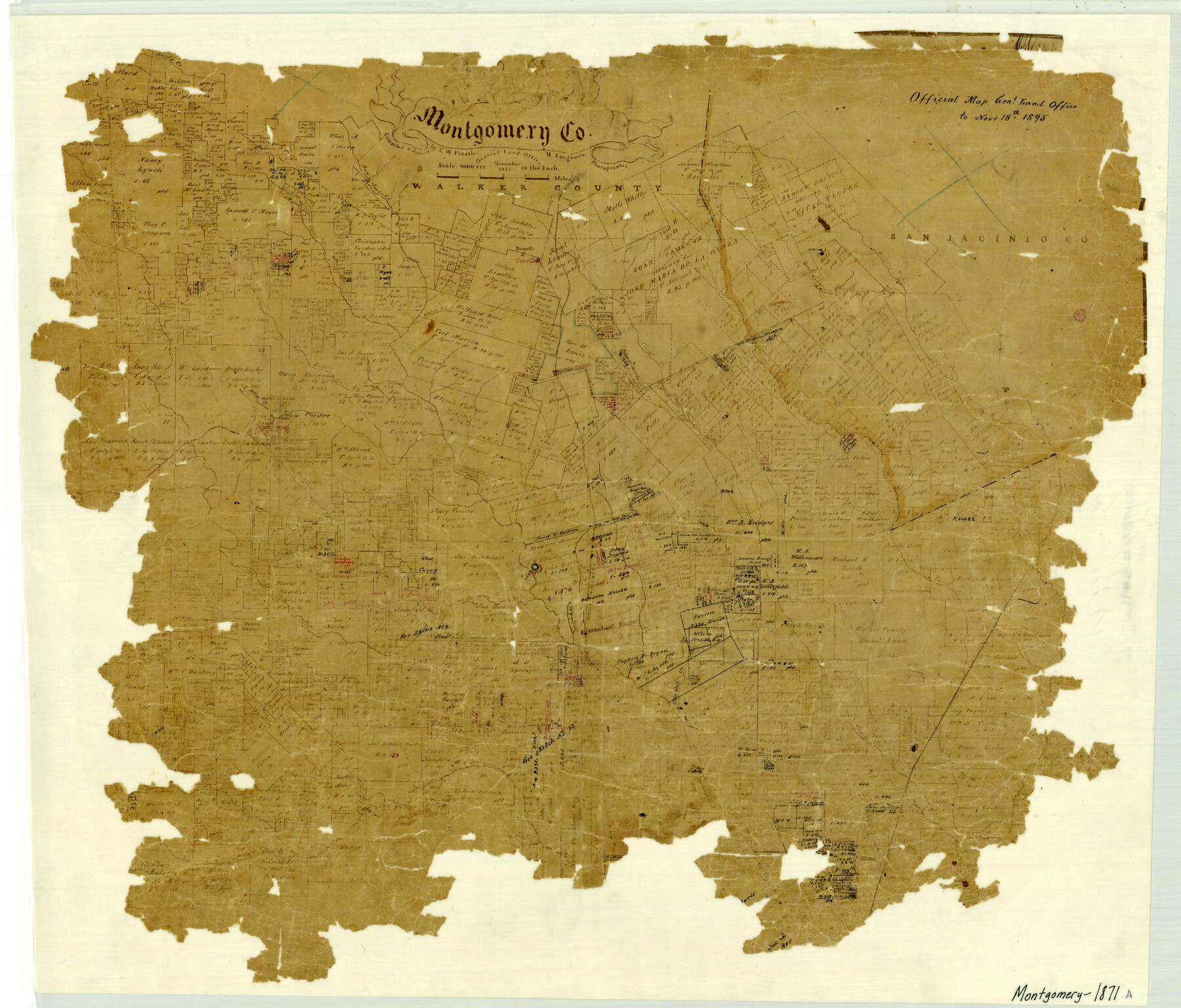
Montgomery County
-
Map/Doc
3891
-
Collection
General Map Collection
-
Object Dates
1871 (Creation Date)
-
People and Organizations
Texas General Land Office (Publisher)
Chas. W. Pressler (Draftsman)
Herman Lungkwitz (Draftsman)
Chas. W. Pressler (Compiler)
-
Counties
Montgomery
-
Subjects
County
-
Height x Width
21.0 x 24.6 inches
53.3 x 62.5 cm
-
Comments
Note on map: "Official Map General Land Office to November 18th 1895".
See counter number 4598 for a more complete copy. -
Features
Little Lake Creek
Christal Creek
Peach Creek
Spring Creek
Gurthouse
Newhart Station
Conroe
Mound Creek
Iron Mound
Clear Creek
Indian Camp Creek
Willis Station
Sandy Creek
Montgomery
Atkins Creek
Lake Creek
Cany Creek
Weirs Creek
Lindley's Creek
Danville
H&GN
Niblett's Creek
Winter's Creek
San Jacinto River
Part of: General Map Collection
Pecos County Working Sketch 54

Print $20.00
- Digital $50.00
Pecos County Working Sketch 54
1948
Size 26.0 x 24.1 inches
Map/Doc 71526
Somervell County Working Sketch 6

Print $20.00
- Digital $50.00
Somervell County Working Sketch 6
1992
Size 23.2 x 21.5 inches
Map/Doc 63910
McMullen County

Print $40.00
- Digital $50.00
McMullen County
1967
Size 50.8 x 35.8 inches
Map/Doc 95586
Aransas County Boundary File 7

Print $2.00
- Digital $50.00
Aransas County Boundary File 7
Size 8.8 x 14.2 inches
Map/Doc 50042
Bastrop County

Print $20.00
- Digital $50.00
Bastrop County
1917
Size 45.5 x 40.8 inches
Map/Doc 66711
Glasscock County Rolled Sketch 18

Print $20.00
- Digital $50.00
Glasscock County Rolled Sketch 18
Size 24.2 x 24.0 inches
Map/Doc 96576
Map of Liberty County

Print $40.00
- Digital $50.00
Map of Liberty County
1903
Size 54.9 x 53.6 inches
Map/Doc 16878
Brewster County Working Sketch 116

Print $20.00
- Digital $50.00
Brewster County Working Sketch 116
1979
Size 25.3 x 38.6 inches
Map/Doc 67716
Brewster County Sketch File 24

Print $40.00
- Digital $50.00
Brewster County Sketch File 24
1957
Size 14.3 x 15.5 inches
Map/Doc 15831
Red River County Sketch File 17b

Print $4.00
- Digital $50.00
Red River County Sketch File 17b
1875
Size 12.9 x 8.1 inches
Map/Doc 35147
Flight Mission No. DQN-2K, Frame 187, Calhoun County

Print $20.00
- Digital $50.00
Flight Mission No. DQN-2K, Frame 187, Calhoun County
1953
Size 18.4 x 22.2 inches
Map/Doc 84328

You may also like
Denton County, Texas

Print $20.00
- Digital $50.00
Denton County, Texas
1870
Size 18.6 x 22.7 inches
Map/Doc 723
Map of Galveston Bay from Lawrence Cove to Stevenson's Station

Print $20.00
- Digital $50.00
Map of Galveston Bay from Lawrence Cove to Stevenson's Station
1851
Size 35.2 x 29.7 inches
Map/Doc 69921
Sketch from Reeves and Pecos Co's.

Print $20.00
- Digital $50.00
Sketch from Reeves and Pecos Co's.
Size 35.1 x 26.1 inches
Map/Doc 91779
University Place - Addition

Print $20.00
- Digital $50.00
University Place - Addition
Size 20.2 x 12.0 inches
Map/Doc 92411
Flight Mission No. BRA-16M, Frame 126, Jefferson County

Print $20.00
- Digital $50.00
Flight Mission No. BRA-16M, Frame 126, Jefferson County
1953
Size 18.5 x 22.5 inches
Map/Doc 85736
Map of Trespalacios River & Bay in Matagorda County showing subdivision thereof for mineral development

Print $20.00
- Digital $50.00
Map of Trespalacios River & Bay in Matagorda County showing subdivision thereof for mineral development
1937
Size 30.5 x 38.9 inches
Map/Doc 3022
Palo Pinto County Rolled Sketch 12

Print $20.00
- Digital $50.00
Palo Pinto County Rolled Sketch 12
1984
Size 32.2 x 28.9 inches
Map/Doc 7192
![91463, [Block B7], Twichell Survey Records](https://historictexasmaps.com/wmedia_w700/maps/91463-1.tif.jpg)
Presidio County Rolled Sketch 57

Print $20.00
- Digital $50.00
Presidio County Rolled Sketch 57
1915
Size 22.8 x 17.3 inches
Map/Doc 7350
Flight Mission No. CRC-3R, Frame 12, Chambers County

Print $20.00
- Digital $50.00
Flight Mission No. CRC-3R, Frame 12, Chambers County
1956
Size 18.4 x 22.2 inches
Map/Doc 84786
Real County Working Sketch 41

Print $20.00
- Digital $50.00
Real County Working Sketch 41
1952
Size 34.1 x 23.6 inches
Map/Doc 71933
[Atchison, Topeka & Santa Fe from Paisano to south of Plata]
![64709, [Atchison, Topeka & Santa Fe from Paisano to south of Plata], General Map Collection](https://historictexasmaps.com/wmedia_w700/maps/64709.tif.jpg)
Print $40.00
- Digital $50.00
[Atchison, Topeka & Santa Fe from Paisano to south of Plata]
Size 32.3 x 120.8 inches
Map/Doc 64709