Edwards County Sketch File ABC
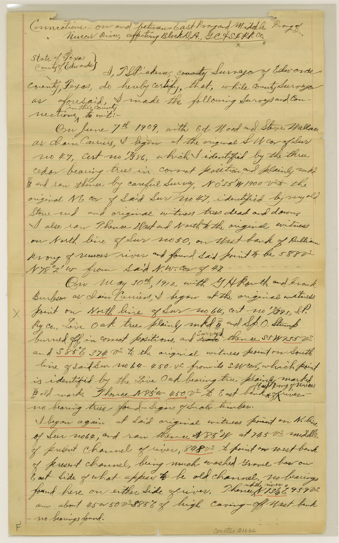
[Connections on and between East Prong and Middle Prong of Nueces River, affecting Block DA, G. C. & S. F. RR. Co.]
-
Map/Doc
21662
-
Collection
General Map Collection
-
Object Dates
1913/1/13 (Creation Date)
1913/1/28 (File Date)
1909/6/7 (Survey Date)
1912/5/30 (Survey Date)
1912/12/2 (Survey Date)
1912/7/25 (Survey Date)
1912/11/9 (Survey Date)
1912/11/20 (Survey Date)
1912/11/23 (Survey Date)
-
People and Organizations
Tom Nowlin (Chainman)
T.S. Pickens (Surveyor/Engineer)
Ed Wood (Chainman)
Steve Wallace (Chainman)
G.H. Routh (Chainman)
Frank Burleson (Chainman)
Will Vernon (Chainman)
Russel Vernon (Chainman)
G.M. Williams (Surveyor/Engineer)
A.P. Allison (Chainman)
Wren Caruthers (Chainman)
R.J. Verner (Chainman)
T.J. Renvis (Chainman)
T.F. Hamrick (Chainman)
A. Pallison (Chainman)
John Saunders (Chainman)
Ben Hamrick (Chainman)
-
Counties
Edwards
-
Subjects
Surveying Sketch File
-
Height x Width
14.5 x 9.1 inches
36.8 x 23.1 cm
-
Medium
paper, manuscript
-
Features
East Prong of Nueces River
Middle Prong of Nueces River
Pulliam Prong of Nuces River
Bull Head Creek
Vance
Nueces River
Part of: General Map Collection
Harrison County

Print $20.00
- Digital $50.00
Harrison County
1857
Size 20.3 x 21.0 inches
Map/Doc 1116
Frio County Working Sketch 24

Print $20.00
- Digital $50.00
Frio County Working Sketch 24
1992
Size 47.0 x 35.2 inches
Map/Doc 69298
Brewster County Working Sketch 115

Print $40.00
- Digital $50.00
Brewster County Working Sketch 115
1985
Size 49.6 x 43.4 inches
Map/Doc 67715
Matagorda County Working Sketch 16

Print $20.00
- Digital $50.00
Matagorda County Working Sketch 16
1960
Size 34.6 x 31.8 inches
Map/Doc 70874
[Map of Matagorda County Showing Abandoned Surveys]
![2066, [Map of Matagorda County Showing Abandoned Surveys], General Map Collection](https://historictexasmaps.com/wmedia_w700/maps/2066.tif.jpg)
Print $40.00
- Digital $50.00
[Map of Matagorda County Showing Abandoned Surveys]
1920
Size 50.3 x 40.2 inches
Map/Doc 2066
Freestone County Sketch File 26

Print $22.00
- Digital $50.00
Freestone County Sketch File 26
1880
Size 8.2 x 13.2 inches
Map/Doc 23096
Duval County Working Sketch 17

Print $20.00
- Digital $50.00
Duval County Working Sketch 17
1939
Size 14.6 x 25.1 inches
Map/Doc 68730
Fisher County Working Sketch Graphic Index

Print $20.00
- Digital $50.00
Fisher County Working Sketch Graphic Index
1944
Size 46.9 x 41.4 inches
Map/Doc 76542
[Beaumont, Sour Lake and Western Ry. Right of Way and Alignment - Frisco]
![64119, [Beaumont, Sour Lake and Western Ry. Right of Way and Alignment - Frisco], General Map Collection](https://historictexasmaps.com/wmedia_w700/maps/64119.tif.jpg)
Print $20.00
- Digital $50.00
[Beaumont, Sour Lake and Western Ry. Right of Way and Alignment - Frisco]
1910
Size 20.0 x 45.8 inches
Map/Doc 64119
Erath County Boundary File 1

Print $8.00
- Digital $50.00
Erath County Boundary File 1
Size 13.1 x 8.8 inches
Map/Doc 53237
Boundary Between the United States & Mexico Agreed Upon by the Joint Commission under the Treaty of Guadalupe Hidalgo

Print $20.00
- Digital $50.00
Boundary Between the United States & Mexico Agreed Upon by the Joint Commission under the Treaty of Guadalupe Hidalgo
1853
Size 24.0 x 18.3 inches
Map/Doc 65396
Edwards County Working Sketch 21

Print $20.00
- Digital $50.00
Edwards County Working Sketch 21
1935
Size 26.7 x 32.0 inches
Map/Doc 68897
You may also like
Section D Tech Memorial Park, Inc.

Print $20.00
- Digital $50.00
Section D Tech Memorial Park, Inc.
Size 19.0 x 20.5 inches
Map/Doc 92300
Crockett County Sketch File 77

Print $8.00
- Digital $50.00
Crockett County Sketch File 77
1932
Size 11.2 x 8.7 inches
Map/Doc 19877

Dawson County Sketch File 15

Print $40.00
- Digital $50.00
Dawson County Sketch File 15
Size 17.8 x 7.9 inches
Map/Doc 20549
Mills County Boundary File 3a

Print $48.00
- Digital $50.00
Mills County Boundary File 3a
Size 14.2 x 8.8 inches
Map/Doc 57287
Webb County Sketch File 50-1

Print $8.00
- Digital $50.00
Webb County Sketch File 50-1
1943
Size 14.5 x 8.9 inches
Map/Doc 39833
Panola County Working Sketch 37

Print $20.00
- Digital $50.00
Panola County Working Sketch 37
1984
Map/Doc 71446
Kinney County

Print $40.00
- Digital $50.00
Kinney County
1955
Size 51.9 x 48.2 inches
Map/Doc 95559
[A. McMillan and vicinity]
![91023, [A. McMillan and vicinity], Twichell Survey Records](https://historictexasmaps.com/wmedia_w700/maps/91023-1.tif.jpg)
Print $20.00
- Digital $50.00
[A. McMillan and vicinity]
Size 22.6 x 18.7 inches
Map/Doc 91023
[West half of county, south of John H. Stephens Block S2]
![90976, [West half of county, south of John H. Stephens Block S2], Twichell Survey Records](https://historictexasmaps.com/wmedia_w700/maps/90976-1.tif.jpg)
Print $2.00
- Digital $50.00
[West half of county, south of John H. Stephens Block S2]
Size 11.8 x 8.7 inches
Map/Doc 90976
[Surveys in the Nacogdoches District, from the Sabine River to Cowleach Fork]
![282, [Surveys in the Nacogdoches District, from the Sabine River to Cowleach Fork], General Map Collection](https://historictexasmaps.com/wmedia_w700/maps/282.tif.jpg)
Print $3.00
- Digital $50.00
[Surveys in the Nacogdoches District, from the Sabine River to Cowleach Fork]
Size 15.6 x 11.5 inches
Map/Doc 282
Webb County Sketch File 15-1

Print $20.00
- Digital $50.00
Webb County Sketch File 15-1
1935
Size 35.0 x 25.2 inches
Map/Doc 12634