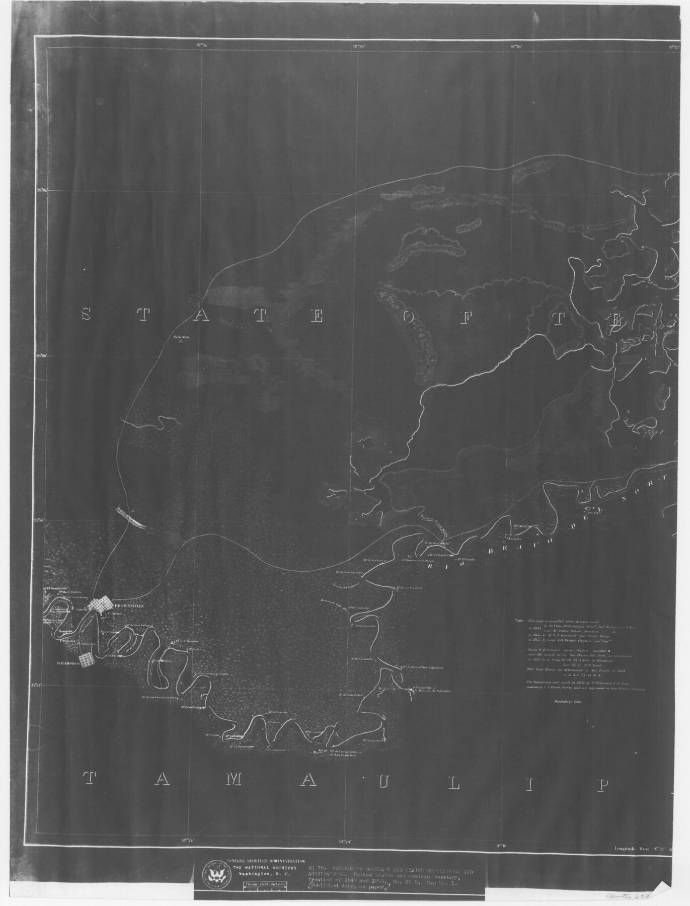
Boundary Between the United States & Mexico Agreed Upon by the Joint Commission under the Treaty of Guadalupe Hidalgo
K-7-67e; K.7.67f
-
Map/Doc
65396
-
Collection
General Map Collection
-
Object Dates
1853 (Creation Date)
-
People and Organizations
F. Herbst (Draftsman)
Arthur Schott (Surveyor/Engineer)
Chas. Radziminski (Surveyor/Engineer)
W.H. Emory (Surveyor/Engineer)
-
Counties
Cameron
-
Subjects
Texas Boundaries
-
Height x Width
24.0 x 18.3 inches
61.0 x 46.5 cm
-
Comments
A composite map of the mouth of the Rio Grande.
From the National Archives, Washington D. C.
Part of: General Map Collection
Fort Bend County Sketch File 12

Print $20.00
- Digital $50.00
Fort Bend County Sketch File 12
Size 24.6 x 18.2 inches
Map/Doc 11503

Flight Mission No. CGI-4N, Frame 22, Cameron County

Print $20.00
- Digital $50.00
Flight Mission No. CGI-4N, Frame 22, Cameron County
1954
Size 18.5 x 22.3 inches
Map/Doc 84655
Flight Mission No. DIX-3P, Frame 139, Aransas County

Print $20.00
- Digital $50.00
Flight Mission No. DIX-3P, Frame 139, Aransas County
1956
Size 17.8 x 18.6 inches
Map/Doc 83769
Dickens County Sketch File D2

Print $44.00
- Digital $50.00
Dickens County Sketch File D2
Size 27.2 x 19.1 inches
Map/Doc 20839
Flight Mission No. DIX-8P, Frame 57, Aransas County

Print $20.00
- Digital $50.00
Flight Mission No. DIX-8P, Frame 57, Aransas County
1956
Size 18.7 x 22.4 inches
Map/Doc 83888
Flight Mission No. CUG-2P, Frame 60, Kleberg County

Print $20.00
- Digital $50.00
Flight Mission No. CUG-2P, Frame 60, Kleberg County
1956
Size 18.4 x 22.3 inches
Map/Doc 86197
Fannin County Boundary File 7

Print $42.00
- Digital $50.00
Fannin County Boundary File 7
Size 5.3 x 31.1 inches
Map/Doc 53313
Flight Mission No. DIX-5P, Frame 141, Aransas County

Print $20.00
- Digital $50.00
Flight Mission No. DIX-5P, Frame 141, Aransas County
1956
Size 17.8 x 18.4 inches
Map/Doc 83802
Flight Mission No. DQO-2K, Frame 96, Galveston County

Print $20.00
- Digital $50.00
Flight Mission No. DQO-2K, Frame 96, Galveston County
1952
Size 18.8 x 22.4 inches
Map/Doc 85023
Edwards County Working Sketch 97

Print $20.00
- Digital $50.00
Edwards County Working Sketch 97
1969
Size 25.5 x 27.6 inches
Map/Doc 68973
Cherokee County Sketch File 8

Print $4.00
- Digital $50.00
Cherokee County Sketch File 8
1854
Size 10.3 x 8.1 inches
Map/Doc 18130
You may also like
Briscoe County Sketch File H

Print $40.00
- Digital $50.00
Briscoe County Sketch File H
1917
Size 17.2 x 13.2 inches
Map/Doc 11005
Plano del Distrilo de Rio Grande Estado de Coahuila

Print $20.00
- Digital $50.00
Plano del Distrilo de Rio Grande Estado de Coahuila
1906
Size 30.3 x 31.5 inches
Map/Doc 1941
Bailey County Sketch File 21

Print $14.00
- Digital $50.00
Bailey County Sketch File 21
Size 11.3 x 8.8 inches
Map/Doc 13990
Robertson Co.

Print $40.00
- Digital $50.00
Robertson Co.
1945
Size 49.5 x 40.3 inches
Map/Doc 95627
Map of Texas compiled from surveys included in the General Land Office

Print $20.00
- Digital $50.00
Map of Texas compiled from surveys included in the General Land Office
1851
Size 31.4 x 25.3 inches
Map/Doc 94417
Culberson County Working Sketch 19

Print $20.00
- Digital $50.00
Culberson County Working Sketch 19
1933
Size 30.0 x 43.6 inches
Map/Doc 68471
Reagan County

Print $20.00
- Digital $50.00
Reagan County
1940
Size 41.6 x 31.4 inches
Map/Doc 77403
Sketch of Menard Co.

Print $20.00
- Digital $50.00
Sketch of Menard Co.
1883
Size 15.1 x 14.2 inches
Map/Doc 536
El Paso County Sketch File 18

Print $20.00
- Digital $50.00
El Paso County Sketch File 18
Size 19.0 x 23.8 inches
Map/Doc 11454
Texas Coordinate File 6

Print $40.00
- Digital $50.00
Texas Coordinate File 6
1946
Size 23.7 x 49.0 inches
Map/Doc 75314
Waller County Working Sketch Graphic Index

Print $20.00
- Digital $50.00
Waller County Working Sketch Graphic Index
1945
Size 46.7 x 27.2 inches
Map/Doc 76730
Upton County Rolled Sketch 24

Print $20.00
- Digital $50.00
Upton County Rolled Sketch 24
1886
Size 17.3 x 43.5 inches
Map/Doc 10043