Deaf Smith County Sketch File 5
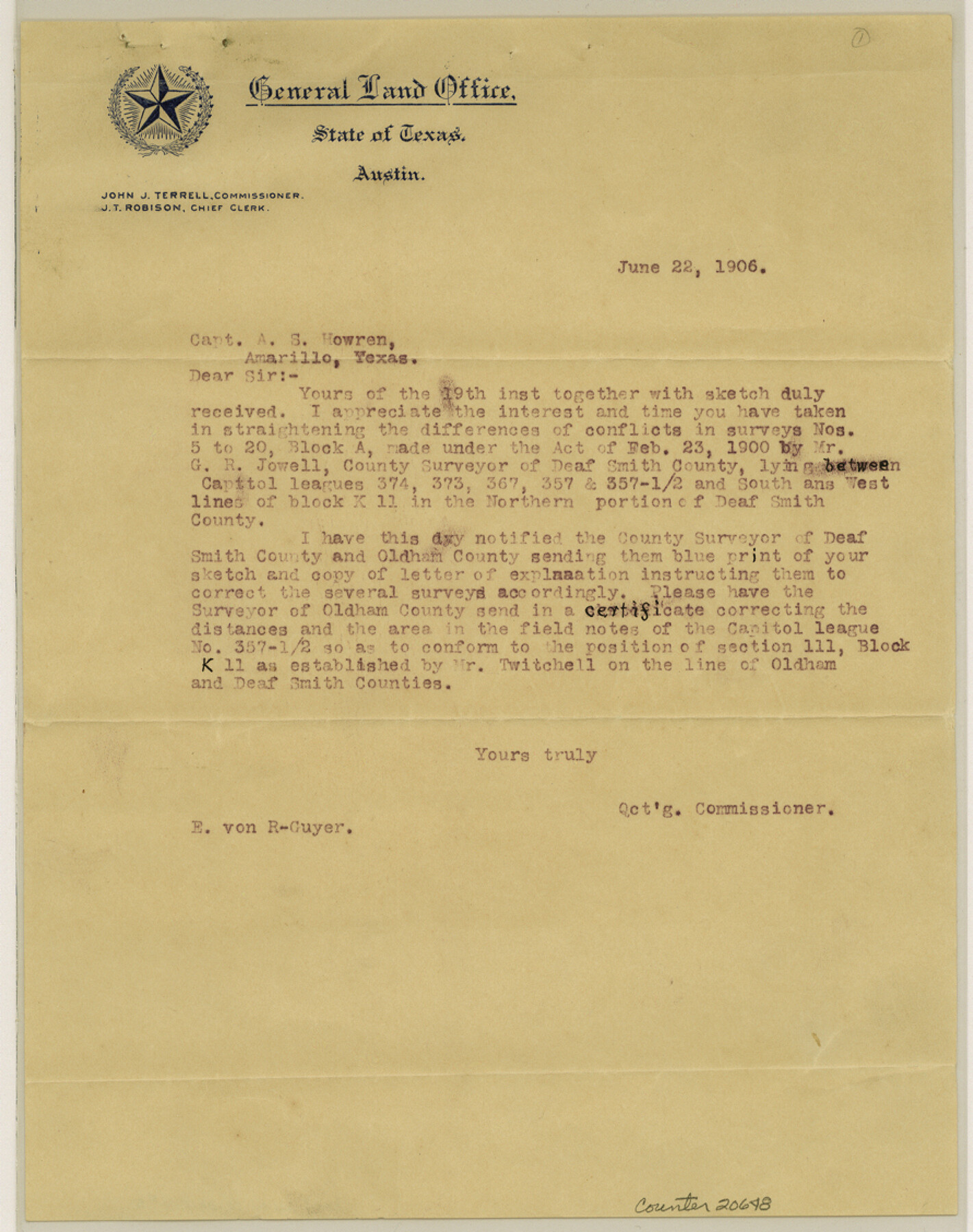
[Explanation suggesting how to correct surveys number 5 to 20, Block A out of conflict with Capitol League 357 1/2, 367, 373 and 374]
-
Map/Doc
20648
-
Collection
General Map Collection
-
Object Dates
1905 (Creation Date)
1906/6/6 (File Date)
1903 (Survey Date)
1903 (Survey Date)
1902 (Survey Date)
1905 (Survey Date)
-
People and Organizations
A.S. Howren (Surveyor/Engineer)
G.R. Jowell (Surveyor/Engineer)
W.D. Twichell (Surveyor/Engineer)
-
Counties
Deaf Smith Oldham
-
Subjects
Surveying Sketch File
-
Height x Width
11.3 x 8.9 inches
28.7 x 22.6 cm
-
Medium
paper, print
Part of: General Map Collection
Val Verde County Working Sketch 63

Print $20.00
- Digital $50.00
Val Verde County Working Sketch 63
1959
Size 23.2 x 32.1 inches
Map/Doc 72198
Map of Val Verde County

Print $40.00
- Digital $50.00
Map of Val Verde County
1898
Size 80.7 x 42.7 inches
Map/Doc 16913
Shackelford County Working Sketch 1

Print $20.00
- Digital $50.00
Shackelford County Working Sketch 1
Size 15.1 x 18.4 inches
Map/Doc 63841
Eastland County Boundary File 26

Print $24.00
- Digital $50.00
Eastland County Boundary File 26
Size 7.8 x 3.5 inches
Map/Doc 52801
Chambers County NRC Article 33.136 Sketch 7

Print $28.00
- Digital $50.00
Chambers County NRC Article 33.136 Sketch 7
2011
Size 18.0 x 24.0 inches
Map/Doc 94753
Nueces River, Corpus Christi Sheet No. 5

Print $6.00
- Digital $50.00
Nueces River, Corpus Christi Sheet No. 5
1938
Size 28.4 x 33.7 inches
Map/Doc 65094
San Jacinto County Rolled Sketch 4

Print $20.00
- Digital $50.00
San Jacinto County Rolled Sketch 4
Size 24.3 x 32.6 inches
Map/Doc 7557
Limestone County Sketch File 10a

Print $22.00
- Digital $50.00
Limestone County Sketch File 10a
Size 12.5 x 15.8 inches
Map/Doc 30173
Sectional Map No. 2 of the lands and the line of the Texas & Pacific Ry. Co. in Howard, Martin, Andrews, Midland and Tom Green Counties

Print $20.00
- Digital $50.00
Sectional Map No. 2 of the lands and the line of the Texas & Pacific Ry. Co. in Howard, Martin, Andrews, Midland and Tom Green Counties
1885
Size 18.9 x 23.2 inches
Map/Doc 4861
Eastland County Working Sketch 27

Print $20.00
- Digital $50.00
Eastland County Working Sketch 27
1952
Size 25.2 x 21.4 inches
Map/Doc 68808
Webb County Rolled Sketch 23

Print $40.00
- Digital $50.00
Webb County Rolled Sketch 23
Size 138.8 x 38.2 inches
Map/Doc 10121
Terrell County Working Sketch 84b

Print $20.00
- Digital $50.00
Terrell County Working Sketch 84b
1992
Size 25.2 x 42.7 inches
Map/Doc 69606
You may also like
Navigation Maps of Gulf Intracoastal Waterway, Port Arthur to Brownsville, Texas

Print $4.00
- Digital $50.00
Navigation Maps of Gulf Intracoastal Waterway, Port Arthur to Brownsville, Texas
1951
Size 16.8 x 21.5 inches
Map/Doc 65437
Map of the upper surveys in Robertson's Colony Sold by the State of Coahuila and Texas

Print $20.00
- Digital $50.00
Map of the upper surveys in Robertson's Colony Sold by the State of Coahuila and Texas
Size 26.8 x 22.0 inches
Map/Doc 82
Map of Cameron County

Print $20.00
- Digital $50.00
Map of Cameron County
1873
Size 42.2 x 22.5 inches
Map/Doc 3364
Zavala County Sketch File 48

Print $6.00
- Digital $50.00
Zavala County Sketch File 48
1942
Size 11.4 x 9.0 inches
Map/Doc 41438
Colorado County Sketch File 4

Print $40.00
- Digital $50.00
Colorado County Sketch File 4
1858
Size 12.8 x 15.7 inches
Map/Doc 18917
Angelina County Sketch File 25

Print $8.00
- Digital $50.00
Angelina County Sketch File 25
1894
Size 7.0 x 10.2 inches
Map/Doc 13069
Throckmorton County Working Sketch 6

Print $20.00
- Digital $50.00
Throckmorton County Working Sketch 6
1952
Size 24.7 x 21.7 inches
Map/Doc 62115
El Paso County State Real Property Sketch 1

Print $20.00
- Digital $50.00
El Paso County State Real Property Sketch 1
2007
Size 24.1 x 36.2 inches
Map/Doc 88670
Montgomery County Sketch File 9

Print $6.00
- Digital $50.00
Montgomery County Sketch File 9
Size 9.0 x 7.6 inches
Map/Doc 31795

Cameron County NRC Article 33.136 Sketch 4

Print $94.00
- Digital $50.00
Cameron County NRC Article 33.136 Sketch 4
2007
Size 22.3 x 34.0 inches
Map/Doc 88721
S. M. S. Flat Top Ranch

Print $6.00
- Digital $50.00
S. M. S. Flat Top Ranch
1955
Size 23.2 x 32.8 inches
Map/Doc 2102