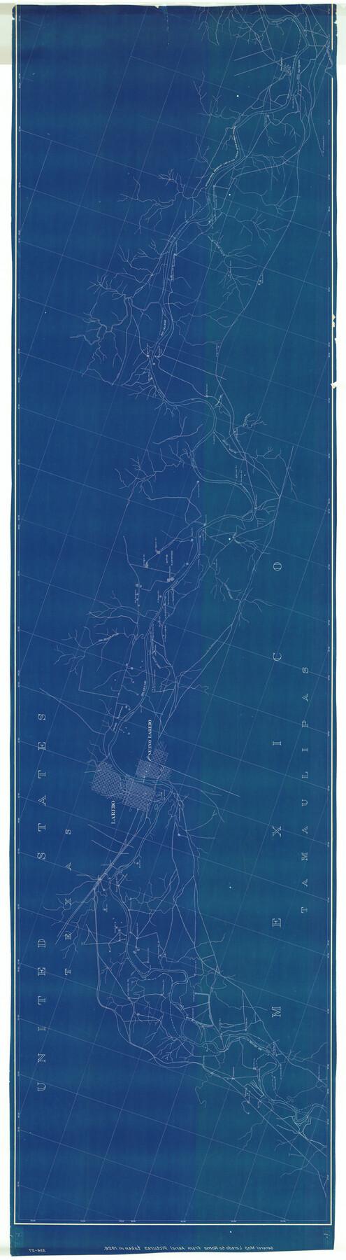
Webb County Rolled Sketch 23
[Map of Rio Grande from Laredo to Roma from aerial pictures taken in 1928]
-
Map/Doc
10121
-
Collection
General Map Collection
-
Counties
Webb
-
Subjects
Surveying Rolled Sketch
-
Height x Width
138.8 x 38.2 inches
352.6 x 97.0 cm
-
Medium
blueprint/diazo
Part of: General Map Collection
Taylor County Rolled Sketch 29

Print $20.00
- Digital $50.00
Taylor County Rolled Sketch 29
Size 20.2 x 24.2 inches
Map/Doc 7922
Val Verde County Rolled Sketch 65

Print $20.00
- Digital $50.00
Val Verde County Rolled Sketch 65
1956
Size 43.0 x 45.0 inches
Map/Doc 10083
Llano County Working Sketch 10

Print $20.00
- Digital $50.00
Llano County Working Sketch 10
1980
Size 21.2 x 15.1 inches
Map/Doc 70628
Rio Grande, Brownsville Sheet No. 1

Print $6.00
- Digital $50.00
Rio Grande, Brownsville Sheet No. 1
1924
Size 28.3 x 35.4 inches
Map/Doc 65130
Runnels County Sketch File H

Print $4.00
Runnels County Sketch File H
1890
Size 14.3 x 8.8 inches
Map/Doc 35450

Chambers County Sketch File 4a

Print $19.00
- Digital $50.00
Chambers County Sketch File 4a
1839
Size 11.4 x 17.8 inches
Map/Doc 17523
Reports of Committees, 23d Congress, 1st Session

Reports of Committees, 23d Congress, 1st Session
Size 9.2 x 6.0 inches
Map/Doc 95690
Knox County Working Sketch 2

Print $20.00
- Digital $50.00
Knox County Working Sketch 2
1913
Size 22.7 x 14.2 inches
Map/Doc 70244
El Paso County

Print $40.00
- Digital $50.00
El Paso County
1881
Size 53.7 x 88.3 inches
Map/Doc 16826
Flight Mission No. DAG-24K, Frame 36, Matagorda County

Print $20.00
- Digital $50.00
Flight Mission No. DAG-24K, Frame 36, Matagorda County
1953
Size 18.5 x 22.2 inches
Map/Doc 86523
Middle Sulphur and South Sulphur Rivers, Horton Sheet

Print $20.00
- Digital $50.00
Middle Sulphur and South Sulphur Rivers, Horton Sheet
1925
Size 42.2 x 40.3 inches
Map/Doc 65171
You may also like
Morris County Working Sketch Graphic Index

Print $20.00
- Digital $50.00
Morris County Working Sketch Graphic Index
1948
Size 42.8 x 20.1 inches
Map/Doc 76649
Crockett County Sketch File 91

Print $76.00
- Digital $50.00
Crockett County Sketch File 91
1968
Size 11.3 x 8.8 inches
Map/Doc 19918
Liberty County Rolled Sketch A

Print $20.00
- Digital $50.00
Liberty County Rolled Sketch A
1919
Size 31.8 x 35.9 inches
Map/Doc 9569
South Part Brewster Co.

Print $40.00
- Digital $50.00
South Part Brewster Co.
1915
Size 36.0 x 51.2 inches
Map/Doc 66733
[Bastrop County, El Paso County, and Gillespie County School Land Leagues and surveys to the East]
![90868, [Bastrop County, El Paso County, and Gillespie County School Land Leagues and surveys to the East], Twichell Survey Records](https://historictexasmaps.com/wmedia_w700/maps/90868-2.tif.jpg)
Print $20.00
- Digital $50.00
[Bastrop County, El Paso County, and Gillespie County School Land Leagues and surveys to the East]
1886
Size 15.9 x 20.1 inches
Map/Doc 90868
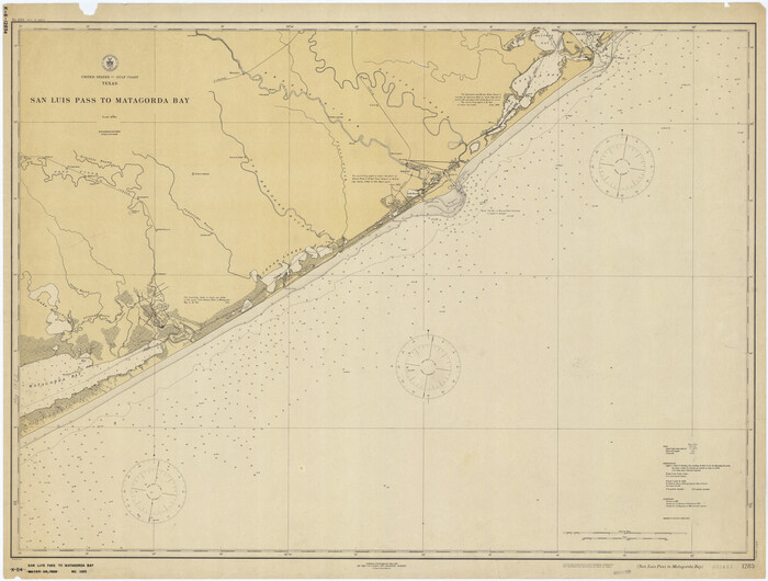
San Luis Pass to Matagorda Bay
Print $20.00
- Digital $50.00
San Luis Pass to Matagorda Bay
1924
Size 34.5 x 45.6 inches
Map/Doc 69959
Kimble County Working Sketch 11

Print $20.00
- Digital $50.00
Kimble County Working Sketch 11
1921
Size 19.0 x 25.1 inches
Map/Doc 70079
Flight Mission No. BRA-6M, Frame 144, Jefferson County

Print $20.00
- Digital $50.00
Flight Mission No. BRA-6M, Frame 144, Jefferson County
1953
Size 18.5 x 22.3 inches
Map/Doc 85445
Hays County Rolled Sketch 33

Print $20.00
- Digital $50.00
Hays County Rolled Sketch 33
Size 15.4 x 19.1 inches
Map/Doc 89012
Hardin County Working Sketch 34

Print $20.00
- Digital $50.00
Hardin County Working Sketch 34
1980
Size 15.7 x 12.1 inches
Map/Doc 63432
Fractional Township No. 8 South Range No. 12 East of the Indian Meridian, Indian Territory

Print $20.00
- Digital $50.00
Fractional Township No. 8 South Range No. 12 East of the Indian Meridian, Indian Territory
1896
Size 19.2 x 24.4 inches
Map/Doc 75223
Fort Bend County Sketch File 10

Print $20.00
- Digital $50.00
Fort Bend County Sketch File 10
Size 16.9 x 24.9 inches
Map/Doc 11501