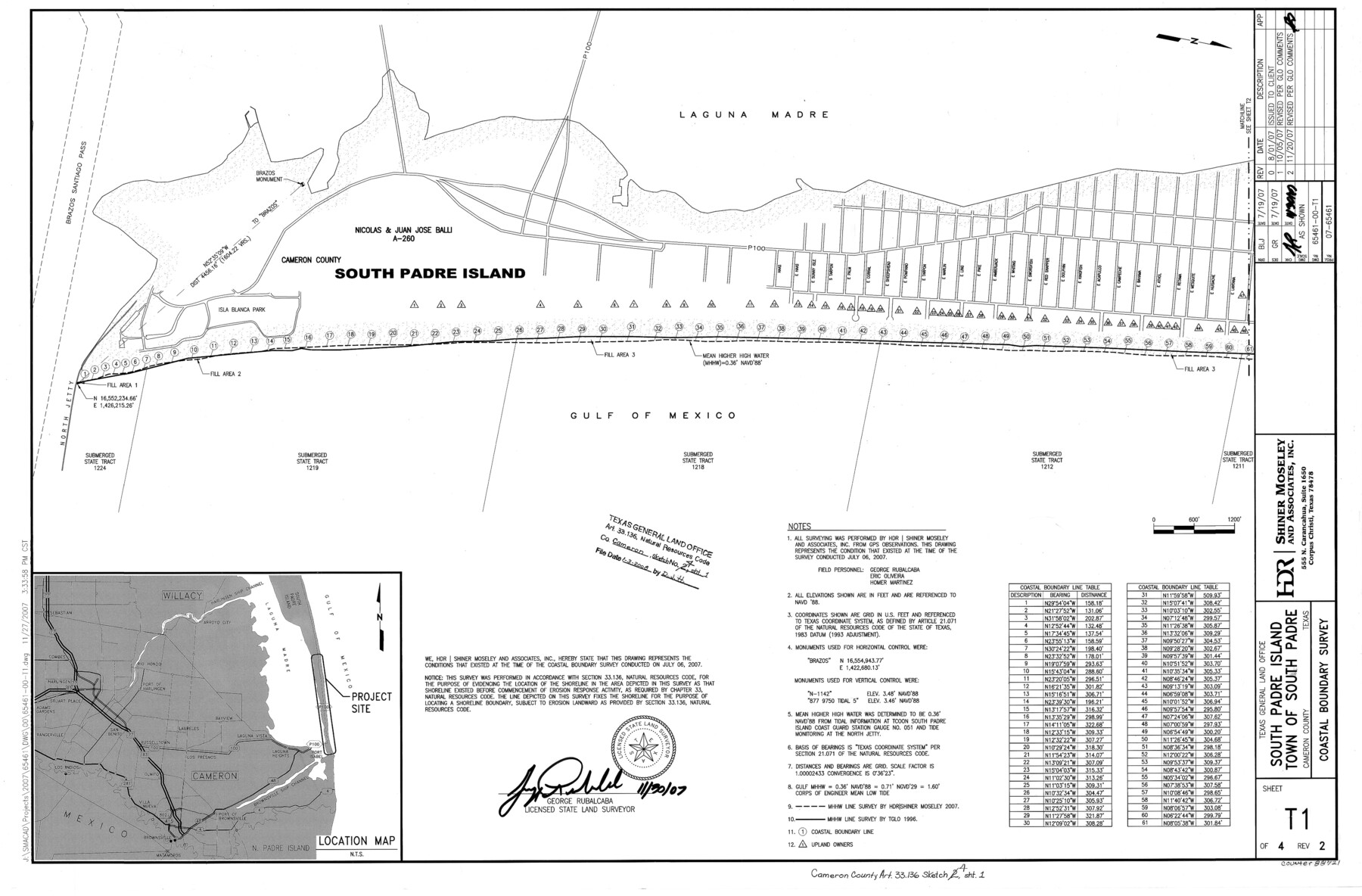
Cameron County NRC Article 33.136 Sketch 4
Mean Higher High Water Line as it existed July 6, 2007 between Juan Jose Balli Survey, A - 260 and State Tracts 1219, 1218, 1212, 1211, 1204, 1203 and parts of 1196 and 1224
-
Map/Doc
88721
-
Collection
General Map Collection
-
Object Dates
2007/8/1 (Creation Date)
2008/1/3 (File Date)
-
People and Organizations
Shiner Moseley and Associates, Inc. (Publisher)
Shiner Moseley and Associates, Inc. (Printer)
GR (Compiler)
BLJ (Draftsman)
George Rubalcaba (Surveyor/Engineer)
-
Counties
Cameron
-
Subjects
Surveying CBS
-
Height x Width
22.3 x 34.0 inches
56.5 x 86.4 cm
-
Medium
multi-page, multi-format
-
Comments
Survey runs northward for approximately six miles from north jetty of Brazos Santiago Pass.
Survey located about 24 miles North 55 degrees East of Brownsville, Texas.
Part of: General Map Collection
Goliad County Sketch File 18

Print $100.00
- Digital $50.00
Goliad County Sketch File 18
1854
Size 12.8 x 15.5 inches
Map/Doc 24255

Sulphur River, Dunbar Creek Sheet

Print $4.00
- Digital $50.00
Sulphur River, Dunbar Creek Sheet
1941
Size 17.2 x 20.9 inches
Map/Doc 65174
Map showing the environs of Brazos Island, Texas

Print $20.00
- Digital $50.00
Map showing the environs of Brazos Island, Texas
Size 18.1 x 25.0 inches
Map/Doc 72926
Orange County Sketch File 4a

Print $22.00
- Digital $50.00
Orange County Sketch File 4a
1874
Size 16.0 x 13.0 inches
Map/Doc 33309

Hardin County Working Sketch 34

Print $20.00
- Digital $50.00
Hardin County Working Sketch 34
1980
Size 15.7 x 12.1 inches
Map/Doc 63432
Flight Mission No. DQO-3K, Frame 27, Galveston County

Print $20.00
- Digital $50.00
Flight Mission No. DQO-3K, Frame 27, Galveston County
1952
Size 18.7 x 22.5 inches
Map/Doc 85068
Map of Hamilton County

Print $20.00
- Digital $50.00
Map of Hamilton County
1872
Size 15.1 x 22.1 inches
Map/Doc 4555
Edwards County Working Sketch 103

Print $20.00
- Digital $50.00
Edwards County Working Sketch 103
1972
Size 25.6 x 44.3 inches
Map/Doc 68979
Mustang Island

Print $20.00
- Digital $50.00
Mustang Island
1908
Size 34.8 x 26.2 inches
Map/Doc 78670
Matagorda County Working Sketch 18

Print $20.00
- Digital $50.00
Matagorda County Working Sketch 18
1961
Size 31.2 x 41.8 inches
Map/Doc 70876
You may also like
Upshur County Working Sketch 15, revised

Print $20.00
- Digital $50.00
Upshur County Working Sketch 15, revised
1996
Size 43.3 x 37.4 inches
Map/Doc 78217
Webb County Sketch File 10-1

Print $20.00
- Digital $50.00
Webb County Sketch File 10-1
1850
Size 14.8 x 15.5 inches
Map/Doc 12625
Hutchinson County Rolled Sketch 44-19

Print $20.00
- Digital $50.00
Hutchinson County Rolled Sketch 44-19
2002
Size 24.0 x 36.0 inches
Map/Doc 77555
Cottle County Sketch File H

Print $12.00
- Digital $50.00
Cottle County Sketch File H
1976
Size 11.2 x 8.7 inches
Map/Doc 19451
Wichita County Working Sketch 2

Print $20.00
- Digital $50.00
Wichita County Working Sketch 2
1913
Size 20.0 x 18.7 inches
Map/Doc 72511
America's Fun-Tier: Texas 1967 Official State Highway Map

Digital $50.00
America's Fun-Tier: Texas 1967 Official State Highway Map
Size 28.2 x 36.4 inches
Map/Doc 94321
Hunt County Sketch File 35

Print $4.00
- Digital $50.00
Hunt County Sketch File 35
Size 5.3 x 8.3 inches
Map/Doc 27148
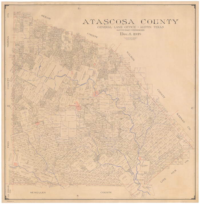
Atascosa County
Print $20.00
- Digital $50.00
Atascosa County
1948
Size 46.6 x 45.4 inches
Map/Doc 73072
Supplemental Plat of a portion of T. 5S., R. 13W., Indian Mer., Oklahoma

Print $4.00
- Digital $50.00
Supplemental Plat of a portion of T. 5S., R. 13W., Indian Mer., Oklahoma
1922
Size 18.3 x 24.4 inches
Map/Doc 75154
Uvalde County Sketch File 27

Print $20.00
- Digital $50.00
Uvalde County Sketch File 27
1972
Size 18.7 x 14.0 inches
Map/Doc 75972
[Sections 67-76, Block 47]
![91789, [Sections 67-76, Block 47], Twichell Survey Records](https://historictexasmaps.com/wmedia_w700/maps/91789-1.tif.jpg)
Print $2.00
- Digital $50.00
[Sections 67-76, Block 47]
Size 11.4 x 8.9 inches
Map/Doc 91789
Henderson County

Print $40.00
- Digital $50.00
Henderson County
1922
Size 33.0 x 62.7 inches
Map/Doc 66861