Gregg County Sketch File 3
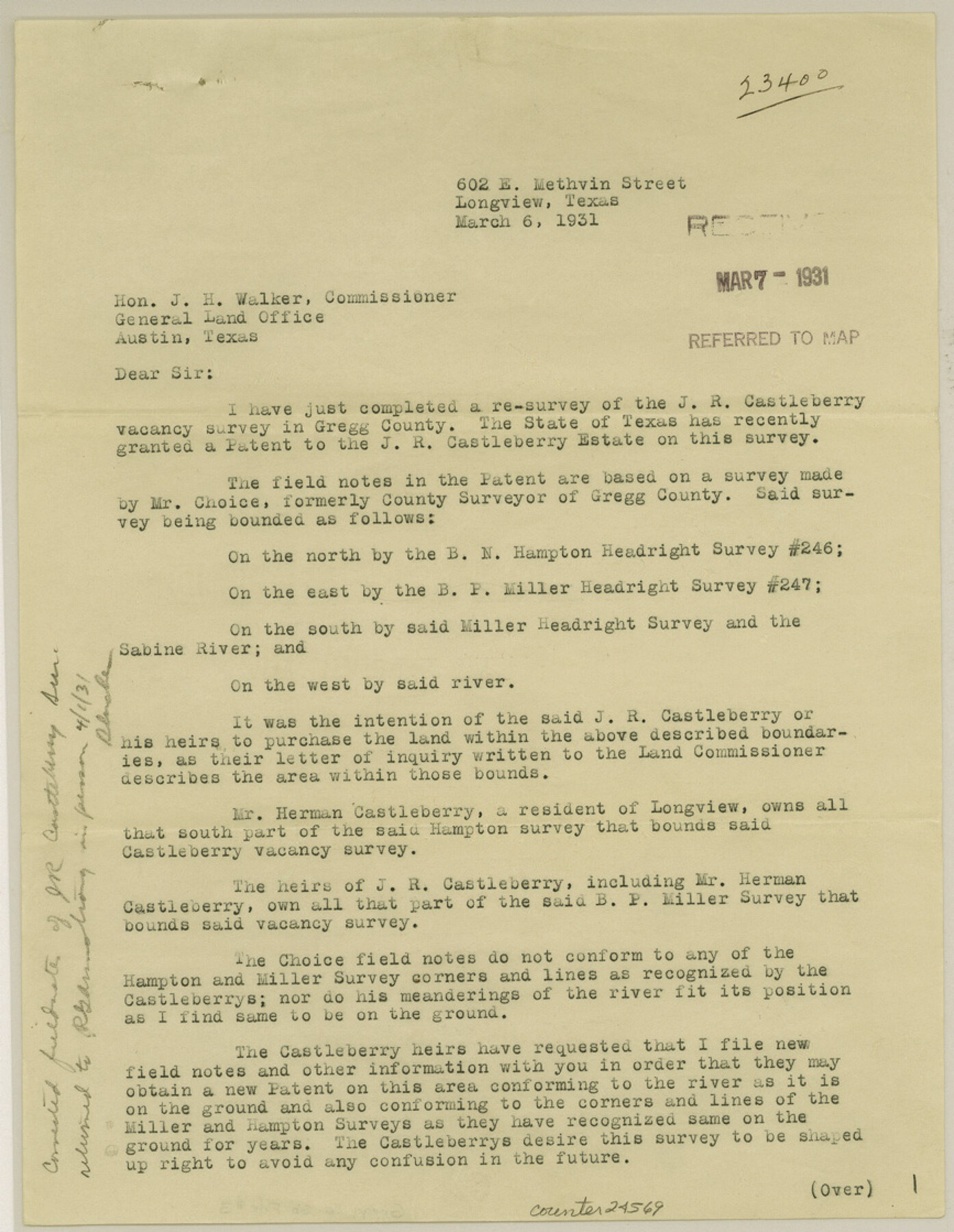
[Surveyor statement regarding resurvey of the J. R. Castleberry vacancy survey]
-
Map/Doc
24569
-
Collection
General Map Collection
-
Object Dates
1931/3/6 (Creation Date)
1931/3/7 (File Date)
-
People and Organizations
R.G. Armstrong (Surveyor/Engineer)
Mr. Choice (Surveyor/Engineer)
Mr. Simmons (Surveyor/Engineer)
-
Counties
Gregg
-
Subjects
Surveying Sketch File
-
Height x Width
11.2 x 8.7 inches
28.4 x 22.1 cm
-
Medium
paper, print
-
Features
Sabine River
Part of: General Map Collection
Presidio County Working Sketch 145

Print $20.00
- Digital $50.00
Presidio County Working Sketch 145
1990
Size 29.5 x 42.7 inches
Map/Doc 71823
Real County Working Sketch 29

Print $40.00
- Digital $50.00
Real County Working Sketch 29
1947
Size 58.2 x 40.5 inches
Map/Doc 71921
Galveston County Working Sketch 11

Print $20.00
- Digital $50.00
Galveston County Working Sketch 11
1967
Size 17.6 x 16.4 inches
Map/Doc 69348
Liberty County Working Sketch 43

Print $20.00
- Digital $50.00
Liberty County Working Sketch 43
1953
Size 30.6 x 43.7 inches
Map/Doc 70502
Milam County Boundary File 2

Print $30.00
- Digital $50.00
Milam County Boundary File 2
Size 12.7 x 8.2 inches
Map/Doc 57202
Flight Mission No. BRA-16M, Frame 122, Jefferson County

Print $20.00
- Digital $50.00
Flight Mission No. BRA-16M, Frame 122, Jefferson County
1953
Size 18.5 x 22.5 inches
Map/Doc 85732
Flight Mission No. CUG-3P, Frame 43, Kleberg County

Print $20.00
- Digital $50.00
Flight Mission No. CUG-3P, Frame 43, Kleberg County
1956
Size 18.6 x 22.3 inches
Map/Doc 86248
Township 11 North Range 15 West, Western District, Louisiana

Print $20.00
- Digital $50.00
Township 11 North Range 15 West, Western District, Louisiana
1834
Size 19.7 x 24.6 inches
Map/Doc 65870
Coke County Working Sketch 13

Print $20.00
- Digital $50.00
Coke County Working Sketch 13
1947
Size 47.0 x 44.5 inches
Map/Doc 68050
Eastern Hemisphere

Print $20.00
- Digital $50.00
Eastern Hemisphere
1885
Size 12.2 x 9.0 inches
Map/Doc 93511
Harris County Historic Topographic 11

Print $20.00
- Digital $50.00
Harris County Historic Topographic 11
1915
Size 29.2 x 22.6 inches
Map/Doc 65821
Maps of Gulf Intracoastal Waterway, Texas - Sabine River to the Rio Grande and connecting waterways including ship channels

Print $20.00
- Digital $50.00
Maps of Gulf Intracoastal Waterway, Texas - Sabine River to the Rio Grande and connecting waterways including ship channels
1966
Size 14.5 x 22.3 inches
Map/Doc 61978
You may also like
Harris County Sketch File 71

Print $5.00
- Digital $50.00
Harris County Sketch File 71
1941
Size 14.4 x 9.0 inches
Map/Doc 25523
Calhoun County NRC Article 33.136 Sketch 11

Digital $50.00
Calhoun County NRC Article 33.136 Sketch 11
2023
Map/Doc 97255
Flight Mission No. BQY-4M, Frame 36, Harris County

Print $20.00
- Digital $50.00
Flight Mission No. BQY-4M, Frame 36, Harris County
1953
Size 18.6 x 22.3 inches
Map/Doc 85251
Sketch Showing Original Corners Affecting Block I and Adjacent Surveys from Actual Connections by W. D. Twichell

Print $20.00
- Digital $50.00
Sketch Showing Original Corners Affecting Block I and Adjacent Surveys from Actual Connections by W. D. Twichell
Size 23.4 x 24.4 inches
Map/Doc 90162
Leon County Working Sketch 21

Print $20.00
- Digital $50.00
Leon County Working Sketch 21
1964
Size 20.9 x 22.9 inches
Map/Doc 70420

Map of Land in State Mineral Land Permit No. 2838 held by E. W. Fry and E. A. Giraud

Print $20.00
- Digital $50.00
Map of Land in State Mineral Land Permit No. 2838 held by E. W. Fry and E. A. Giraud
1919
Size 18.4 x 37.3 inches
Map/Doc 91837
[J. B. Sneed, S. Robinson, and vicinity]
![91041, [J. B. Sneed, S. Robinson, and vicinity], Twichell Survey Records](https://historictexasmaps.com/wmedia_w700/maps/91041-1.tif.jpg)
Print $20.00
- Digital $50.00
[J. B. Sneed, S. Robinson, and vicinity]
Size 32.4 x 12.8 inches
Map/Doc 91041
Galveston County NRC Article 33.136 Sketch 30

Print $20.00
- Digital $50.00
Galveston County NRC Article 33.136 Sketch 30
2005
Size 12.1 x 15.5 inches
Map/Doc 82997
Jack County Working Sketch 7

Print $20.00
- Digital $50.00
Jack County Working Sketch 7
1953
Size 37.2 x 31.9 inches
Map/Doc 66433
Anderson County Boundary File 10

Print $13.00
- Digital $50.00
Anderson County Boundary File 10
Size 16.0 x 10.2 inches
Map/Doc 49759
Crockett County Working Sketch 59

Print $20.00
- Digital $50.00
Crockett County Working Sketch 59
1955
Size 46.1 x 29.3 inches
Map/Doc 68392