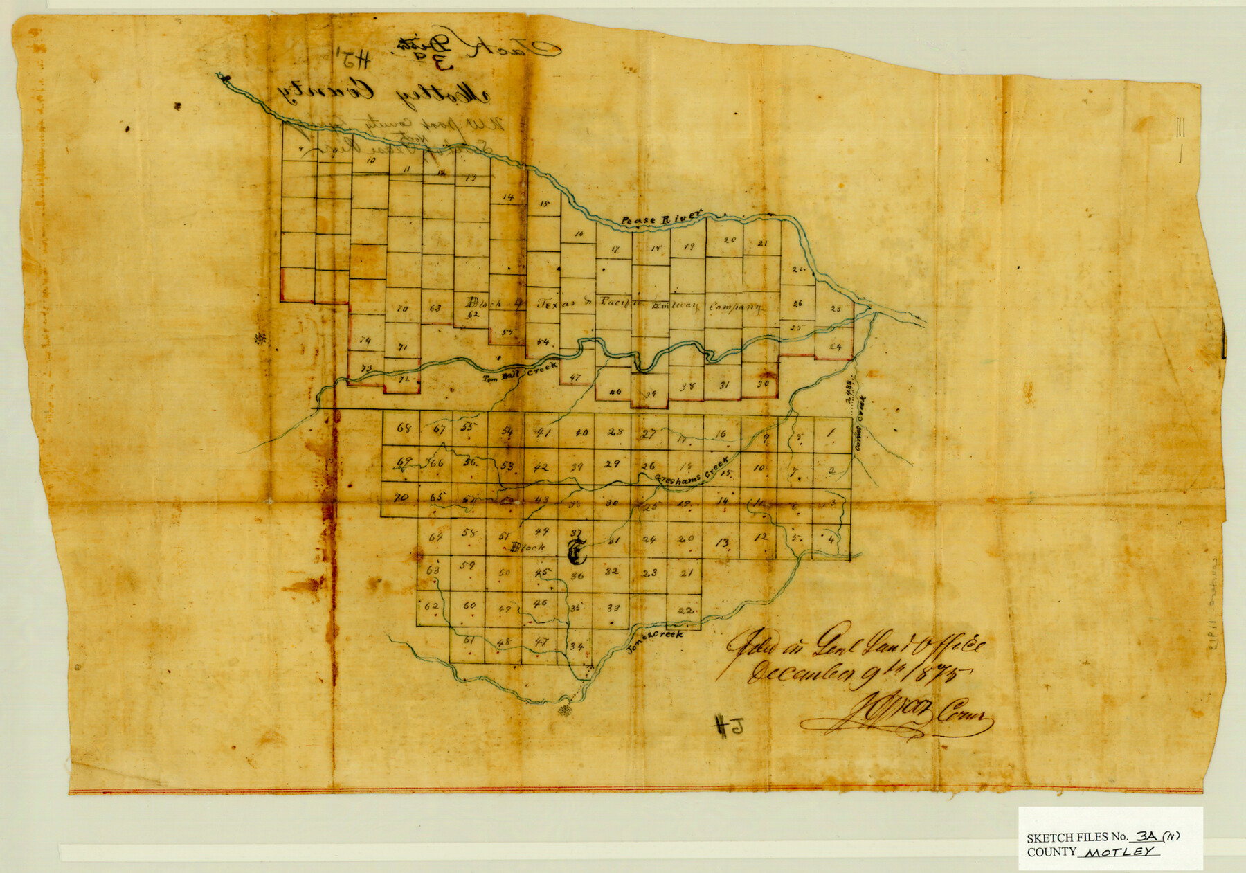
Motley County Sketch File 3A (N)
[Northern part of Motley County]
-
Map/Doc
42136
-
Collection
General Map Collection
-
Object Dates
12/9/1875 (File Date)
-
Counties
Motley
-
Subjects
Surveying Sketch File
-
Height x Width
12.3 x 17.5 inches
31.2 x 44.5 cm
-
Medium
paper, manuscript
-
Features
Pease River
Tom Ball Creek
Gresham's Creek
Carrie's Creek
Jones Creek
Part of: General Map Collection
Map of Wichita County

Print $20.00
- Digital $50.00
Map of Wichita County
1874
Size 22.8 x 21.0 inches
Map/Doc 4142
Kleberg County Rolled Sketch 10-29

Print $20.00
- Digital $50.00
Kleberg County Rolled Sketch 10-29
1952
Size 37.6 x 33.8 inches
Map/Doc 9373

Shelby County Working Sketch 2

Print $20.00
- Digital $50.00
Shelby County Working Sketch 2
Size 32.9 x 37.3 inches
Map/Doc 63855
Randall County

Print $20.00
- Digital $50.00
Randall County
1958
Size 43.0 x 35.1 inches
Map/Doc 73269
Controlled Mosaic by Jack Amman Photogrammetric Engineers, Inc - Sheet 40

Print $20.00
- Digital $50.00
Controlled Mosaic by Jack Amman Photogrammetric Engineers, Inc - Sheet 40
1954
Size 20.0 x 24.0 inches
Map/Doc 83495
Map of section no. 11 of a survey of Padre Island made for the Office of the Attorney General of the State of Texas

Print $40.00
- Digital $50.00
Map of section no. 11 of a survey of Padre Island made for the Office of the Attorney General of the State of Texas
1941
Size 60.1 x 40.4 inches
Map/Doc 2267
Walker County Working Sketch 11

Print $20.00
- Digital $50.00
Walker County Working Sketch 11
1935
Size 28.2 x 38.8 inches
Map/Doc 72291
Falls County Working Sketch 4

Print $20.00
- Digital $50.00
Falls County Working Sketch 4
1943
Size 24.3 x 22.0 inches
Map/Doc 69179
Preliminary Chart of Entrance to Brazos River, Texas

Print $20.00
- Digital $50.00
Preliminary Chart of Entrance to Brazos River, Texas
Size 17.6 x 19.8 inches
Map/Doc 81986
Floyd County Sketch File 32a

Print $20.00
- Digital $50.00
Floyd County Sketch File 32a
1952
Size 36.5 x 33.1 inches
Map/Doc 10451
Flight Mission No. BRE-2P, Frame 25, Nueces County

Print $20.00
- Digital $50.00
Flight Mission No. BRE-2P, Frame 25, Nueces County
1956
Size 18.4 x 22.2 inches
Map/Doc 86734
You may also like
Brown County Working Sketch 9

Print $40.00
- Digital $50.00
Brown County Working Sketch 9
1977
Size 63.7 x 36.4 inches
Map/Doc 67774
From Citizens of Colorado and Matagorda Counties for the Creation of a New County (Unnamed), August 6, 1840

Print $20.00
From Citizens of Colorado and Matagorda Counties for the Creation of a New County (Unnamed), August 6, 1840
2020
Size 18.5 x 21.7 inches
Map/Doc 96389
Milam County Boundary File 1

Print $8.00
- Digital $50.00
Milam County Boundary File 1
Size 12.7 x 8.2 inches
Map/Doc 57198
Texas, Matagorda Bay, Matagorda

Print $20.00
- Digital $50.00
Texas, Matagorda Bay, Matagorda
1933
Size 34.2 x 45.2 inches
Map/Doc 69990
[Blocks 3, Q, and vicinity]
![91274, [Blocks 3, Q, and vicinity], Twichell Survey Records](https://historictexasmaps.com/wmedia_w700/maps/91274-1.tif.jpg)
Print $20.00
- Digital $50.00
[Blocks 3, Q, and vicinity]
Size 19.4 x 8.9 inches
Map/Doc 91274
Map of DeWitt County

Print $20.00
- Digital $50.00
Map of DeWitt County
1881
Size 21.7 x 24.3 inches
Map/Doc 3478
Colorado River, Willow Creek Valley Sheet[/Near Kirtley, Texas Mapped in Cooperation with Commissioner's Court of Fayette Co.]
![65322, Colorado River, Willow Creek Valley Sheet[/Near Kirtley, Texas Mapped in Cooperation with Commissioner's Court of Fayette Co.], General Map Collection](https://historictexasmaps.com/wmedia_w700/maps/65322.tif.jpg)
Print $20.00
- Digital $50.00
Colorado River, Willow Creek Valley Sheet[/Near Kirtley, Texas Mapped in Cooperation with Commissioner's Court of Fayette Co.]
1938
Size 38.2 x 40.8 inches
Map/Doc 65322
Aransas County Sketch File 20

Print $4.00
- Digital $50.00
Aransas County Sketch File 20
1896
Size 8.2 x 10.2 inches
Map/Doc 13155
Llano County Working Sketch 14

Print $20.00
- Digital $50.00
Llano County Working Sketch 14
1989
Size 14.6 x 34.7 inches
Map/Doc 70632
Brewster County Rolled Sketch 101

Print $40.00
- Digital $50.00
Brewster County Rolled Sketch 101
1927
Size 74.2 x 42.3 inches
Map/Doc 9192
Fannin County Working Sketch 10

Print $20.00
- Digital $50.00
Fannin County Working Sketch 10
1989
Size 26.5 x 38.0 inches
Map/Doc 69164
Map Showing Location of Dallas & Greenville Railroad through Rockwall County, Texas

Print $3.00
- Digital $50.00
Map Showing Location of Dallas & Greenville Railroad through Rockwall County, Texas
Size 7.9 x 17.5 inches
Map/Doc 64485