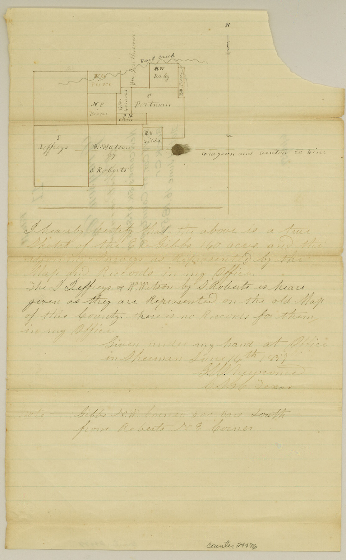
Grayson County Sketch File 11
[Sketch of surveys in southwest corner of county on Buck Creek]
-
Map/Doc
24476
-
Collection
General Map Collection
-
Object Dates
1857/6/16 (Creation Date)
-
People and Organizations
G.W. Newcome (Surveyor/Engineer)
S. Roberts (Surveyor/Engineer)
-
Counties
Grayson Denton Cooke
-
Subjects
Surveying Sketch File
-
Height x Width
13.0 x 8.0 inches
33.0 x 20.3 cm
-
Medium
paper, manuscript
-
Features
Buck Creek
Part of: General Map Collection
Travis County Sketch File 6

Print $8.00
- Digital $50.00
Travis County Sketch File 6
1841
Size 13.8 x 10.9 inches
Map/Doc 38283
Sutton County Sketch File JAC

Print $20.00
- Digital $50.00
Sutton County Sketch File JAC
Size 24.5 x 23.4 inches
Map/Doc 12398
Brewster County Rolled Sketch 68

Print $20.00
- Digital $50.00
Brewster County Rolled Sketch 68
1940
Size 20.2 x 29.9 inches
Map/Doc 5234
Dimmit County Sketch File 11b

Print $20.00
- Digital $50.00
Dimmit County Sketch File 11b
1909
Size 30.3 x 26.7 inches
Map/Doc 11340
Liberty County Working Sketch 67

Print $20.00
- Digital $50.00
Liberty County Working Sketch 67
1971
Size 35.3 x 44.5 inches
Map/Doc 70527
Comanche County Sketch File 17

Print $14.00
- Digital $50.00
Comanche County Sketch File 17
Size 8.5 x 8.2 inches
Map/Doc 19086
Crockett County Working Sketch 41

Print $20.00
- Digital $50.00
Crockett County Working Sketch 41
1928
Size 20.4 x 23.2 inches
Map/Doc 68374
Oldham County Working Sketch 6

Print $40.00
- Digital $50.00
Oldham County Working Sketch 6
1981
Size 32.4 x 50.4 inches
Map/Doc 71328
Dallas County Working Sketch 1

Print $20.00
- Digital $50.00
Dallas County Working Sketch 1
Size 41.4 x 28.3 inches
Map/Doc 68567
Dickens County Sketch File G

Print $8.00
- Digital $50.00
Dickens County Sketch File G
Size 12.0 x 8.7 inches
Map/Doc 20854
Rains County Boundary File 2

Print $4.00
- Digital $50.00
Rains County Boundary File 2
Size 8.2 x 5.8 inches
Map/Doc 58092
San Jacinto County Sketch File 1

Print $22.00
San Jacinto County Sketch File 1
1852
Size 7.9 x 12.4 inches
Map/Doc 35694
You may also like
Dimmit County Sketch File 13

Print $46.00
- Digital $50.00
Dimmit County Sketch File 13
1884
Size 22.6 x 36.5 inches
Map/Doc 11341
Medina County

Print $40.00
- Digital $50.00
Medina County
1915
Size 50.1 x 42.1 inches
Map/Doc 66924
Panola County Working Sketch 16

Print $20.00
- Digital $50.00
Panola County Working Sketch 16
1945
Map/Doc 71425
Atascosa County Sketch File 11

Print $4.00
- Digital $50.00
Atascosa County Sketch File 11
1856
Size 10.8 x 8.6 inches
Map/Doc 13767
[G. B. & C. Blocks K3 and K4]
![90512, [G. B. & C. Blocks K3 and K4], Twichell Survey Records](https://historictexasmaps.com/wmedia_w700/maps/90512-1.tif.jpg)
Print $20.00
- Digital $50.00
[G. B. & C. Blocks K3 and K4]
Size 14.0 x 14.5 inches
Map/Doc 90512
Collingsworth County Rolled Sketch 2A

Print $20.00
- Digital $50.00
Collingsworth County Rolled Sketch 2A
1888
Size 15.3 x 45.8 inches
Map/Doc 8638
University Land Field Notes for Blocks 12, 13, and 14 in Andrews County, and Block 11 in Andrews and Winkler Counties

University Land Field Notes for Blocks 12, 13, and 14 in Andrews County, and Block 11 in Andrews and Winkler Counties
Map/Doc 81711
General Highway Map, Gillespie County, Texas

Print $20.00
General Highway Map, Gillespie County, Texas
1940
Size 18.2 x 24.9 inches
Map/Doc 79099
Eastland County Rolled Sketch 18

Print $20.00
- Digital $50.00
Eastland County Rolled Sketch 18
Size 27.3 x 25.9 inches
Map/Doc 5776
General Highway Map, Kendall County, Texas

Print $20.00
General Highway Map, Kendall County, Texas
1961
Size 18.3 x 24.6 inches
Map/Doc 79549
Kent County Sketch File 8

Print $20.00
- Digital $50.00
Kent County Sketch File 8
Size 19.0 x 40.8 inches
Map/Doc 10515
Culberson County Working Sketch 85
Print $20.00
- Digital $50.00
Culberson County Working Sketch 85
1981
Size 37.0 x 36.9 inches
Map/Doc 68539